Digital registration of 3D laser radar data based on manually selected fiducials

a technology of laser radar and data, applied in the direction of distance measurement, height/levelling measurement, instruments, etc., can solve the problems of difficult acquisition of precise and absolute positioning information, inability to meet the requirements of precise positioning, so as to improve the target identification capability, and improve the target identification of an obscured target

Inactive Publication Date: 2012-01-05
UNITED STATES OF AMERICA THE AS REPRESENTED BY THE SEC OF THE ARMY
View PDF3 Cites 9 Cited by
  • Summary
  • Abstract
  • Description
  • Claims
  • Application Information

AI Technical Summary

Benefits of technology

[0006]The disclosure relates to registering 3D data sets to map obscured objects based on scene fiducials, where a fiducial is defined as an easily identifiable physical reference point common to each data set. The fiducials are used as anchor points to create a digital mapping relating two or more data sets. An exemplary embodiment defines a three-dimensional linear shift vector for each data voxel, wherein four fiducials are used to completely define the mapping for a 3D space. Using an exemplary registration algorithm as disclosed provides a novel approach to automatically make fine adjustments to the 3D data registration. The tedious technique of shifting data sets relative to each other, in many degrees of freedom, is eliminated. Instead, a fine adjust is applied to the digital mapping function, through fiducial perturbation.
[0007]Accordingly, in one aspect, a digital registration of 3D laser radar data is disclosed for imaging processing based on selected fiducials using a laser radar system. Such a digital registration comprises: raster scanning by a scanner of the laser radar system a target from at least two different positions; using predetermined fiducials to create a digital mapping relating the raster scans from the at least two different positions to each other; defining a three-dimensional linear shift vector for data voxels from the digital mapping; and image mapping using the three-dimensional linear shift vector to improve target-identification of an obscured target.
[0008]In another aspect, a registration algorithm is disclosed to process 3D laser radar data sets using a computing device to map obscured objects based on fine adjustments to the 3D data registration. Such a registration algorithm comprises: defining fiducials based on an imaged reference point identifiable in each data set; using the fiducials as anchor points to create a digital mapping relating two or more data sets; and defining a three-dimensional linear shift vector for each data voxel to allow fine adjustments to the 3D data registration and improve target-identification of an obscured target.
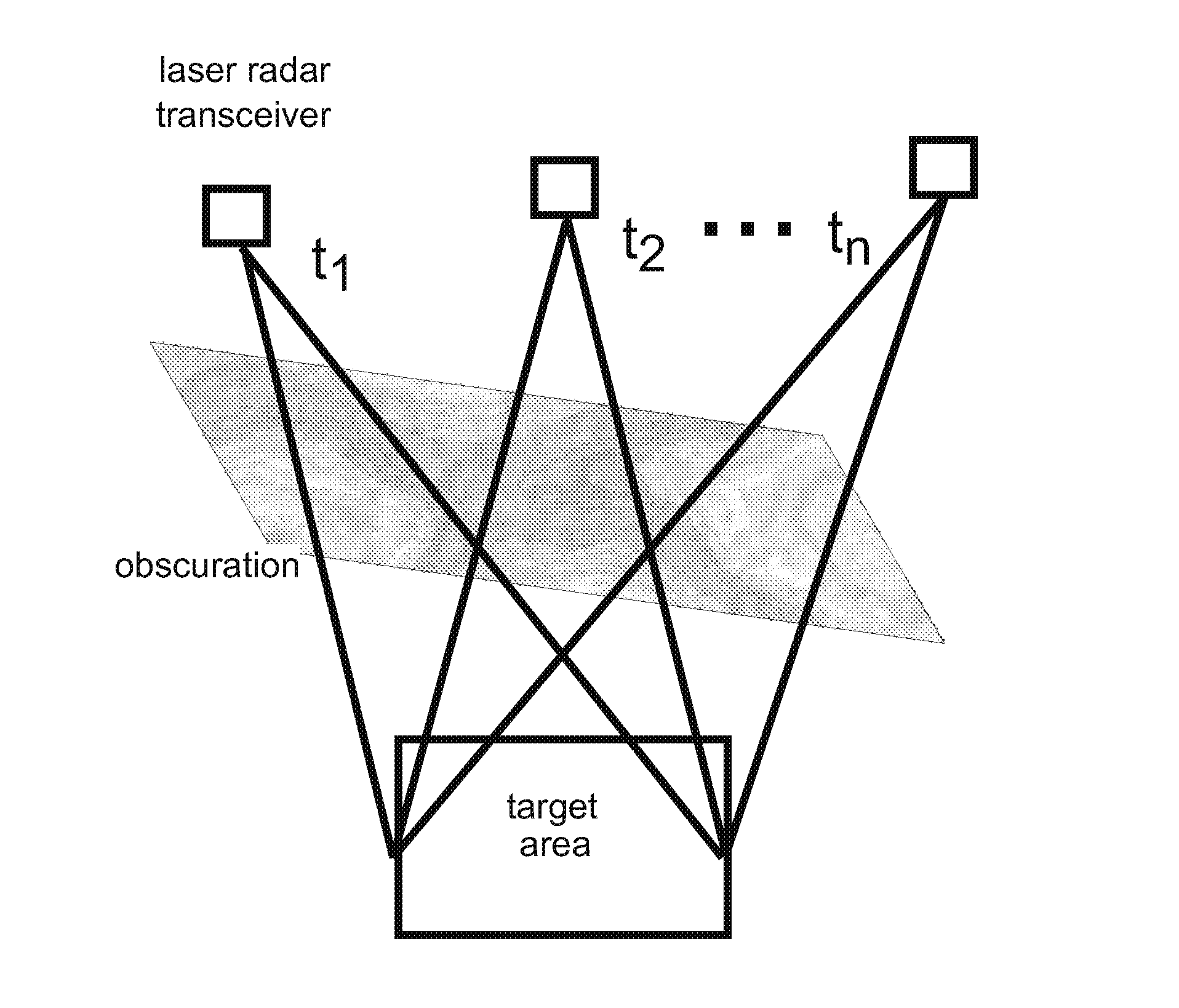
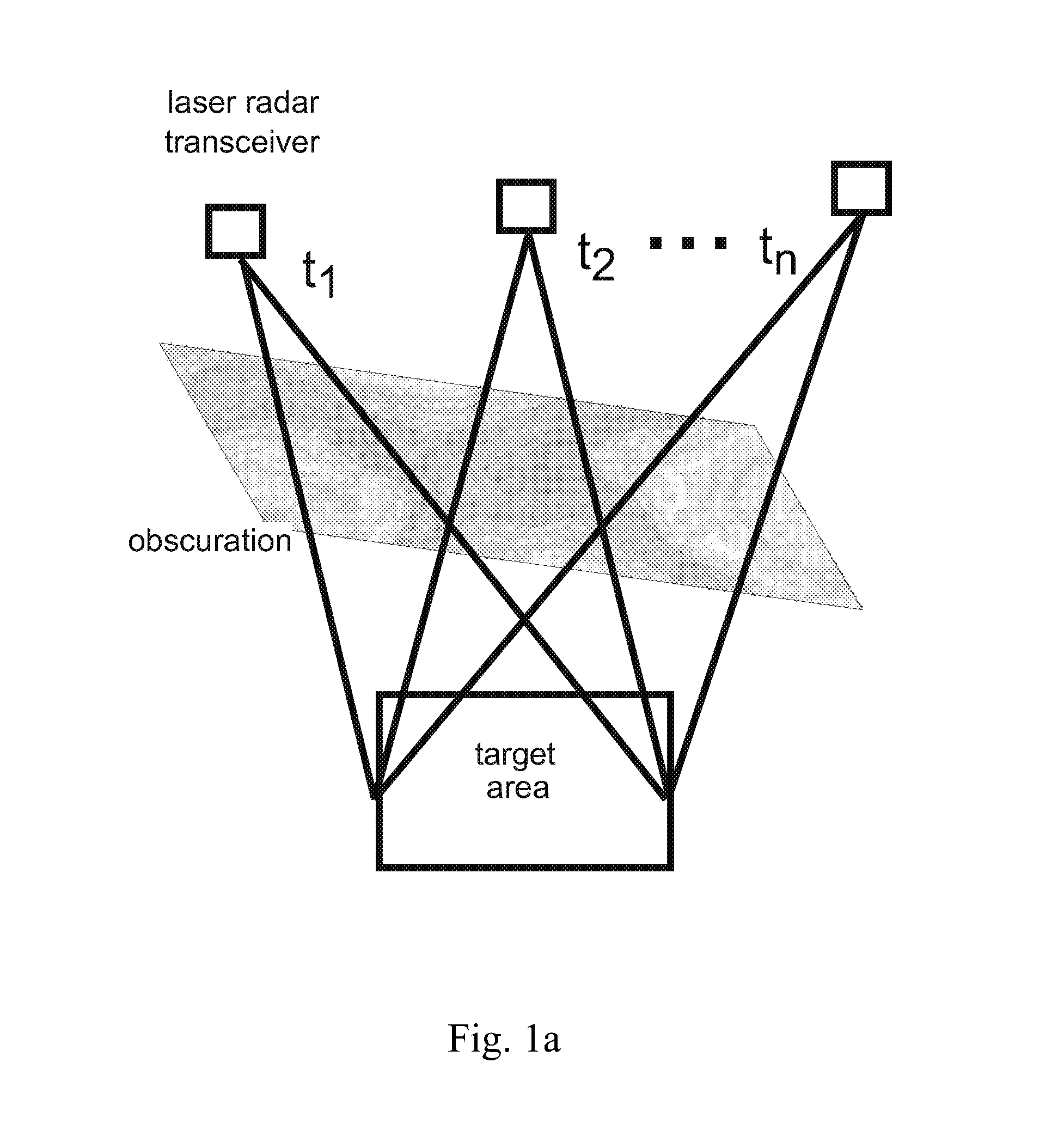
[0009]The present disclosure is based on identifying a target by accumulating data collected through the small gaps in the foliage canopy or camouflage net with a 3D imaging laser radar. Even for heavy (but not complete) obscuration, some amount of laser radiation will pass through gaps and scatter at the target, resulting in a limited number of target-voxels in any single data set. Subsequent laser radar data acquisitions of the same target area, but from varying positions, will each pass through a different set of holes in the foliage, resulting in an independent collection of target-voxels. As target-voxels from different data acquisitions are registered and accumulated, a complete 3D representation of the target may be constructed. Once the data is registered, 3D laser radar data acquired from differing aspect angles improves the target-identification capability of heavily obscured targets.
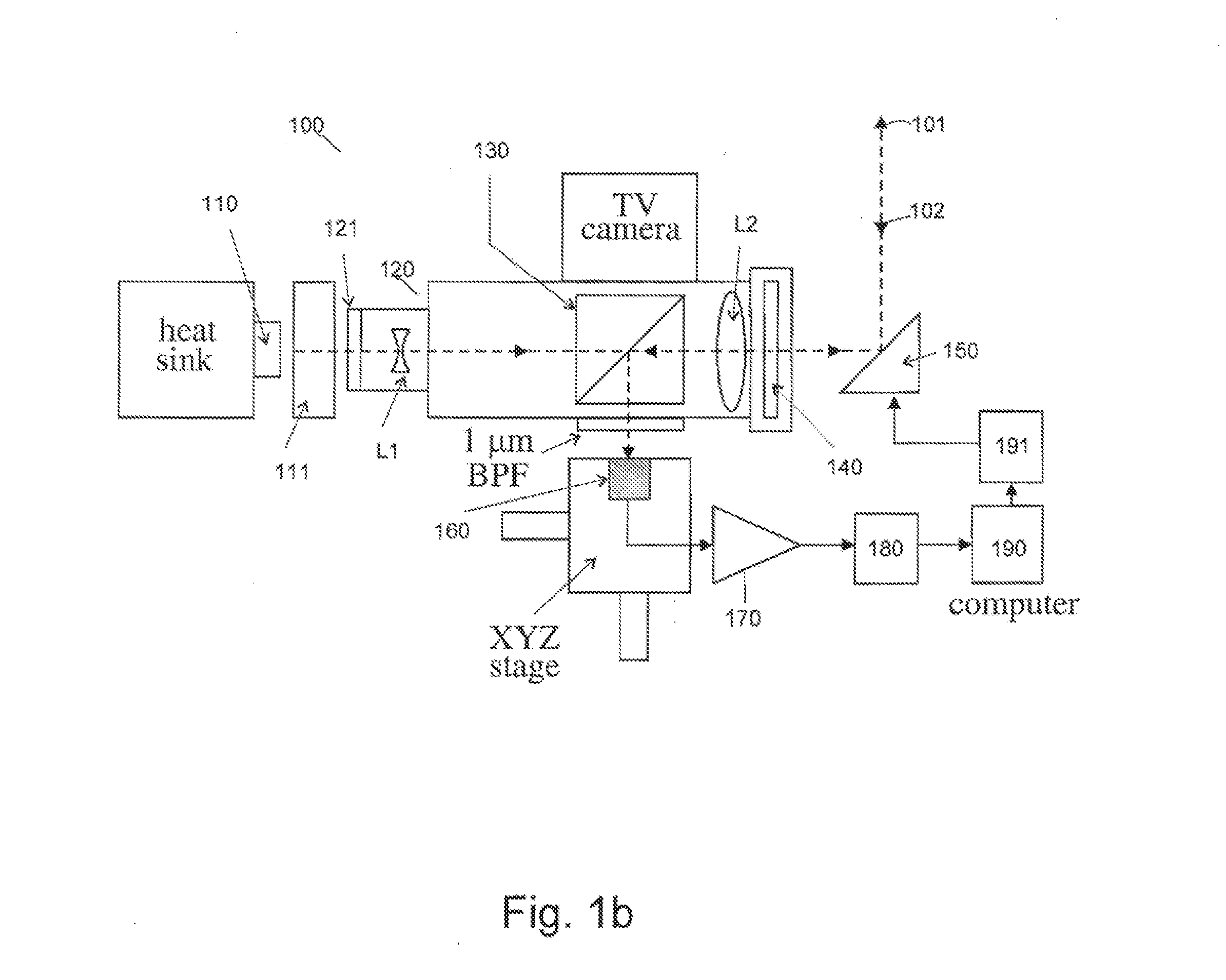
[0010]Accordingly, yet in one aspect, a 3D laser radar system is disclosed based on a laser transceiver sensor system. Such a 3D laser radar system comprises: producing nominal pulses of laser from a microchip towards scanners, the scanners being computer controlled to scan a monostatic transceiver field of view directed towards a scene having an obscured target, wherein said scanning yields at least one data set relating to said obscured target acquired from one location during one time period, and another data set relating to said obscured target acquired from another location during another time period; reflecting a returning radiation from the scene by a polarization beam splitter for focusing on a preamplifier module, wherein a post-amplifier further amplifies the output of the preamplifier module; digitizing said amplified output for input to a computing device to acquire data from differing aspect angles; computer processing data from one 3D imaging laser radar location at one aspect angle, wherein the target is obscured such that some amount of laser radiation passes through and scatter at the target; identifying the target by accumulating one data set acquired from said one 3D imaging laser radar location based on said laser radiation scattered at the target, resulting in a limited number of target-voxels; computer processing another data set from another 3D imaging laser radar location at another aspect angle, wherein the target obscuration from said another aspect angle is such that another amount of another laser radiation passes through another set of gaps and scatter differently at the target; identifying the target by accumulating said another data set acquired from said another 3D imaging laser radar location, resulting in a differing number of target-voxels in the another data set; and as target-voxels from different data acquisitions are registered and accumulated, constructing a complete 3D representation of the obscured target, wherein the 3D representation of the obscured target acquired from differing aspect angles improves identification of the obscured target.

Problems solved by technology

A potential drawback of this straightforward method is the necessity for precise positioning information, such as the location of the laser radar transceiver at the time of acquisition, the location of some object clearly visible in the scene, and / or the precise pointing direction of the acquisition system.
Precise and absolute positioning information may be difficult to acquire, require special equipment, or simply not be available in some cases.
Even for heavy (but not complete) obscuration, some amount of laser radiation will pass through gaps and scatter at the target, resulting in a limited number of target-voxels in any single data set.

Method used


Image

  • Digital registration of 3D laser radar data based on manually selected fiducials
  • Digital registration of 3D laser radar data based on manually selected fiducials
  • Digital registration of 3D laser radar data based on manually selected fiducials

Examples


Embodiment Construction

[0027]Laser Radar and 3D Data Collection

[0028]A short-pulsed, direct-detection, scanning laser radar is disclosed to record and process 3D data. Such a ladar system can be based on a single laser, single detector, common-aperture architecture. An exemplary ladar system (e.g., 100) employs a diode pumped, passively Q-switched, Nd:YAG, micro-chip laser (e.g., 110) capable of emitting short laser pulses (on the order of about ˜1.2 nanosecond) of high peak power (e.g., 5 kW). In one exemplary embodiment, two galvanometer-scanning mirrors (e.g., 150) direct the laser radiation (e.g., 101) to the area of interest, scanning the scene in a raster fashion. The laser radar return signals (e.g., 102)) are detected by a photodiode 160, e.g., an InGaAs avalanche photodiode, and then amplified, digitized and stored, e.g., in a computer 190 storage device. This data results in a regularly spaced 3D array representing the volume of interest, as shown in FIG. 2.

[0029]An exemplary embodiment is shown...


PUM


Abstract

A system and method for registering 3D data sets is disclosed based on manual fiducial selection. The technique is useful in imaging obscured targets with 3-D imaging laser radars. For such an exemplary method, which defines a three-dimensional linear shift vector for each data voxel, four fiducials are required to completely define the mapping for a 3D space. An exemplary registration algorithm as disclosed provides an approach to automatically make fine adjustments to the 3D data registration. The tedious technique of shifting data sets relative to each other, in many degrees of freedom, is eliminated. Instead, a fine adjust is applied to the digital mapping function, through fiducial perturbation.

Description

GOVERNMENT INTEREST[0001]The invention described herein may be manufactured, used, sold, imported, and / or licensed by or for the Government of the United States of America.FIELD OF THE DISCLOSURE[0002]The disclosure relates to imaging obscured targets using three-dimensional (3D) imaging laser radar.BACKGROUND INFORMATION[0003]In the past, numerous targeting scenarios have been investigated. Usually, laser radar data is recorded of a target or scene that is obscured by foliage, camouflage netting, or other obscurations. The data acquisition process is repeated for the same target, but from different locations, or view-points. A frequency-modulated ladar can be used to study the problem and record multi-aspect laser radar imagery.[0004]One of the most straightforward techniques for registering 3D data is to calculate the actual physical location of the voxels in each data set. Other researchers have successfully “stitched together” multi-aspect laser radar data by this technique. A p...

Claims


Application Information

Patent Timeline
Patent Type & Authority Applications(United States)
IPC IPC(8): G01S13/89
CPCG01S17/89
Inventor SCHILLING, BRADLEY W.THOMAS, BRIAN W.BARR, DALLAS N.TRUSSELL, CHARLIE W.
Owner UNITED STATES OF AMERICA THE AS REPRESENTED BY THE SEC OF THE ARMY
Why Eureka
Try Eureka