Accuracy-based significant point derivation from dense 3D point clouds for terrain modeling

a point derivation and accurate technology, applied in the field of three-dimensional point cloud data for terrain modeling, can solve the problems of large quantity of information normally associated with point cloud data, process can be destructive of important information contained in the data, and point cloud data has consistently proven to be problemati

Active Publication Date: 2013-06-06
HARRIS CORP
View PDF6 Cites 88 Cited by
  • Summary
  • Abstract
  • Description
  • Claims
  • Application Information

AI Technical Summary

Benefits of technology

[0006]Embodiments of the invention concern a method for processing point cloud data defined within a three-dimensional coordinate system. The method includes calculating a mean z coordinate value for points within the point cloud. Thereafter an initial set of points is selected from the point cloud data. The initial set of points are those which have z coordinate values which deviate from the mean by at least an initial significance value. This value can be set directly or indirectly by a terrain modeler or computed from statistical assessments of the data that follow as a part of the quality control that accompanies terrain surveys in the existing art. Thereafter, a triangulated irregular network (TIN) is constructed using the initial set of points. The method continues by determining if there is a significant point that exists among the points contained within an x, y extent of each triangle. If so, the TIN is updated to include the initial set of points and any significant points determined to exist within the triangles that form the TIN. Thereafter, the method continues by repeating the determining and the updating steps until there are no additional significant points found within the triangles. A point is identified as a significant point only if it satisfies certain criteria. For example, the point must have a z coordinate value that deviates from a plane of the triangle within which the x, y position of the point is contained. The point must deviate from the plane by an amount which is greater than or equal to all other of the other points within the x, y extent of the triangle. Further, the point must have a z coordinate value that deviates from the plane of the triangle by an amount exceeding an allowable vertical error (AVE) limit. At the conclusion of processing, a subset of all significant cloud points can be made or significance can be associated with each evaluated point and this value can then be used in subsequent retrievals of the data.

Problems solved by technology

Although LIDAR has many advantages, there are certain problems associated with its use.
One such problem is the very large quantity of information usually associated with point cloud data.
In fact, point cloud data has consistently proven to be problematic due to its enormous density and volume.
The new representation is typically produced in the form of a regular or periodic grid of data points, but this process can be destructive of important information contained in the data.
However, the various conventional schemes that have been devised in the art have not been found to provide completely satisfactory results.
One problem with this approach is that it can and will miss significant points in the terrain, such as peaks in hills and bottoms of valleys in the terrain.
Accordingly, a grid scheme will also inevitably miss significant points within each grid, or will be subject to the limitations of the interpolation scheme used.
Avoidance of these problems requires an extremely small post spacing of points in a DEM and the size of these DEM files themselves then become a processing issue.
Still, these compression methods often require conversion to and from the compressed form to perform work with the data, and do not seek to remove truly redundant or insignificant points from the scheme.

Method used


Image

  • Accuracy-based significant point derivation from dense 3D point clouds for terrain modeling
  • Accuracy-based significant point derivation from dense 3D point clouds for terrain modeling
  • Accuracy-based significant point derivation from dense 3D point clouds for terrain modeling

Examples


Embodiment Construction

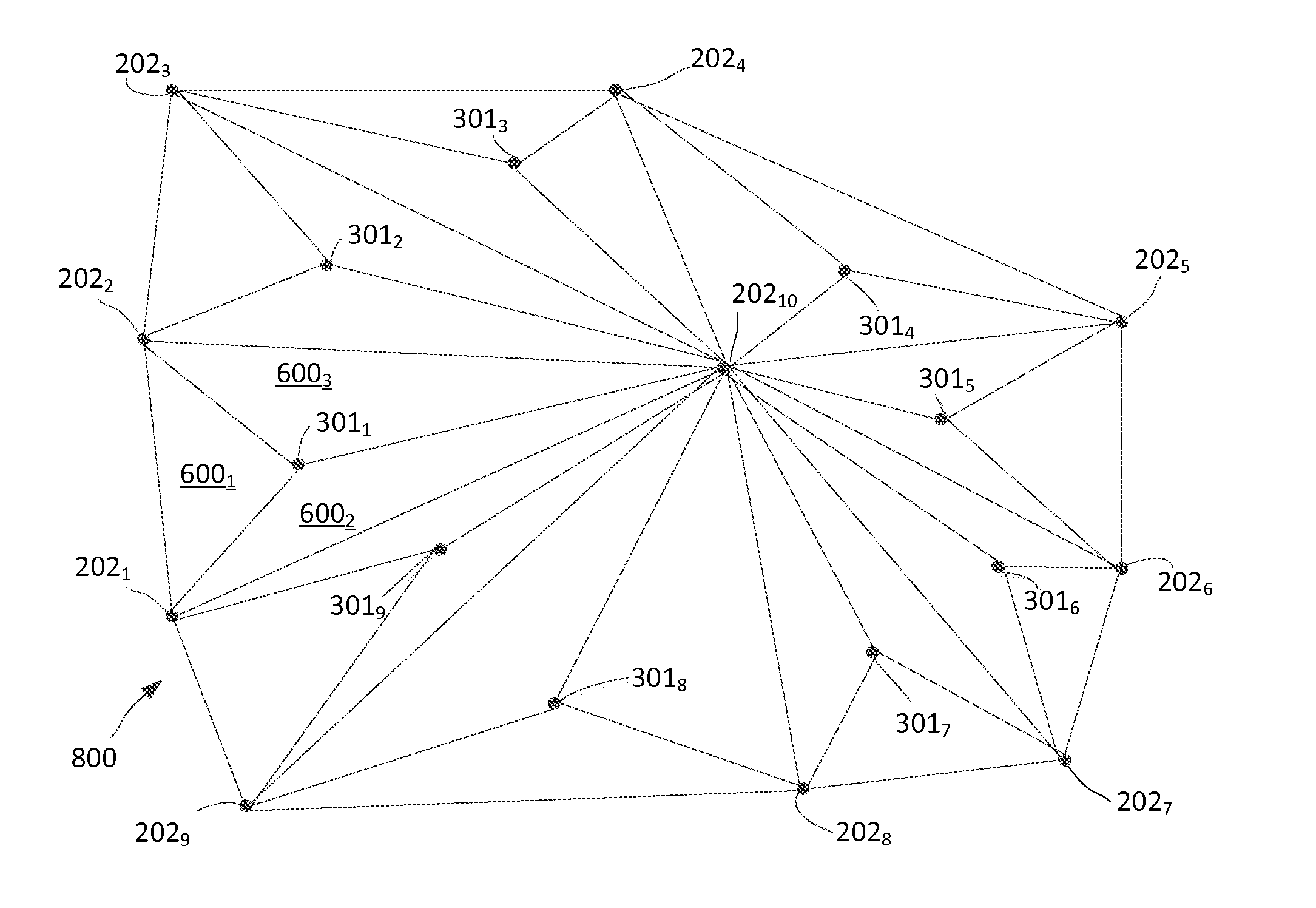
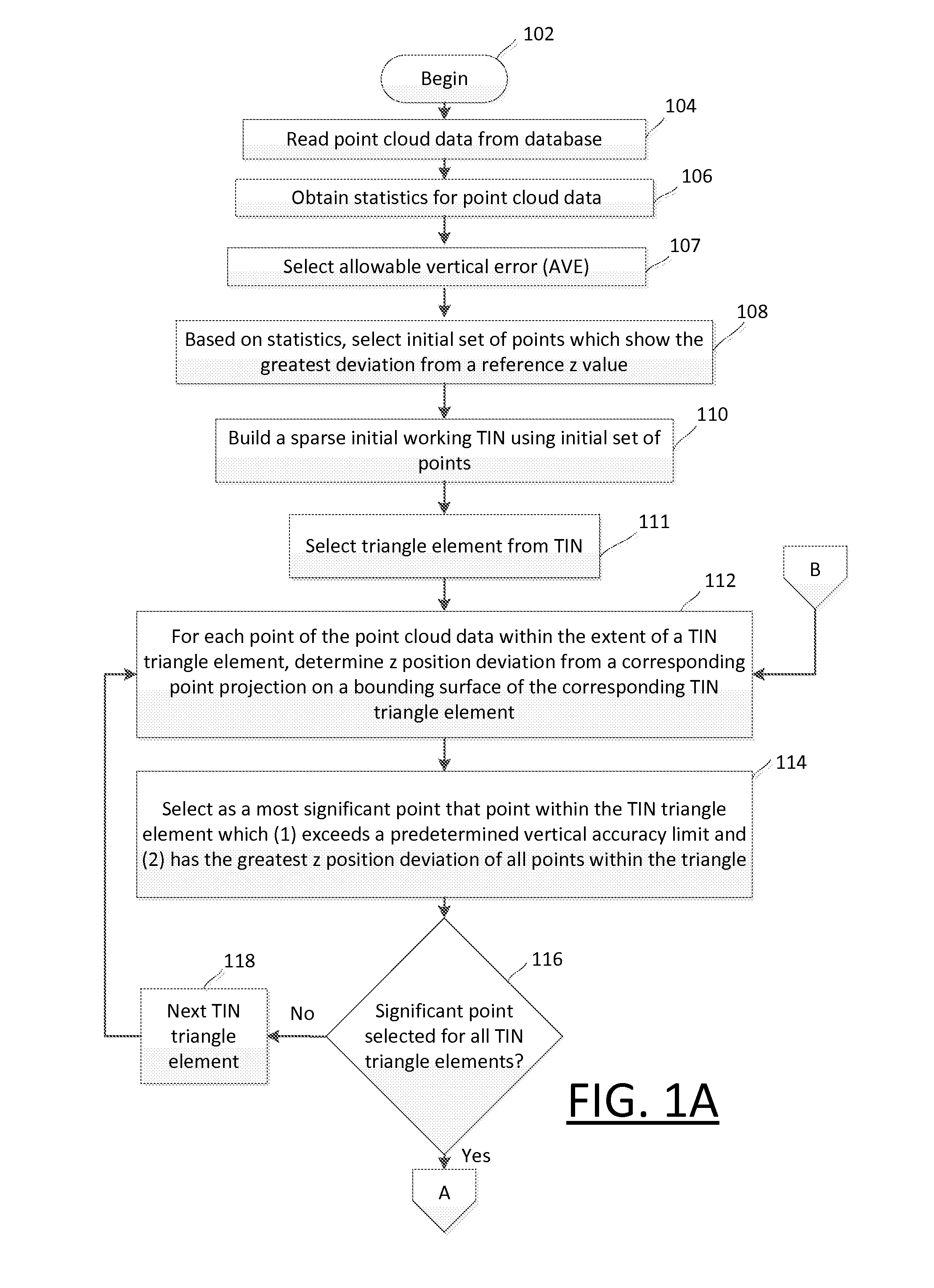
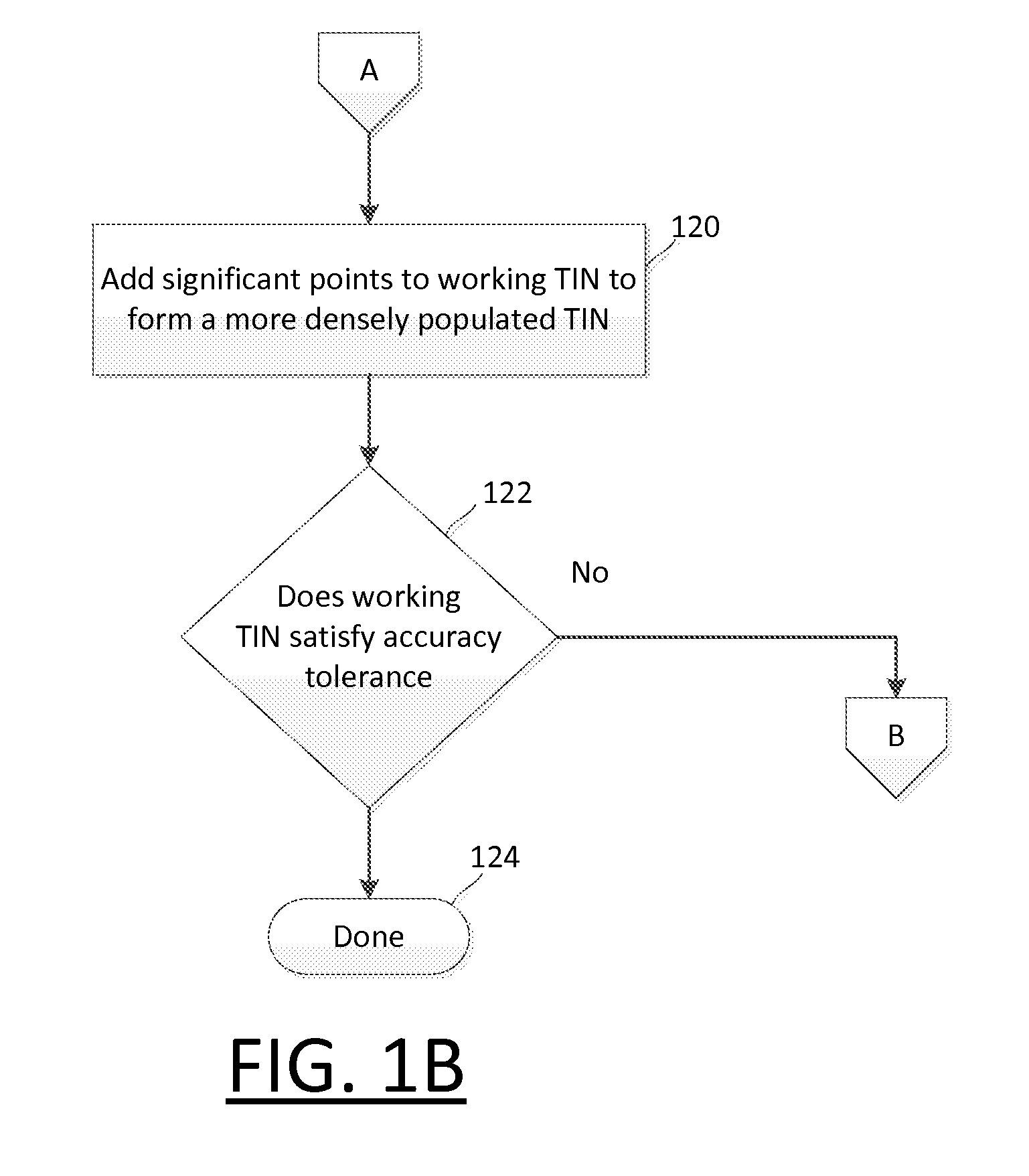
[0022]The invention is described with reference to the attached figures. The figures are not drawn to scale and they are provided merely to illustrate the instant invention. Several aspects of the invention are described below with reference to example applications for illustration. It should be understood that numerous specific details, relationships, and methods are set forth to provide a full understanding of the invention. One having ordinary skill in the relevant art, however, will readily recognize that the invention can be practiced without one or more of the specific details or with other methods. In other instances, well-known structures or operation are not shown in detail to avoid obscuring the invention. The invention is not limited by the illustrated ordering of acts or events, as some acts may occur in different orders and / or concurrently with other acts or events. Furthermore, not all illustrated acts or events are required to implement a methodology in accordance wit...


PUM


Abstract

Method includes calculating a mean z coordinate value for points within the point cloud. An initial set of points is selected which have z coordinate values which deviate from the mean by at least an initial value. Thereafter, a triangulated irregular network (TIN) is constructed using the initial set of points. The method continues by determining if there is a significant point that exists among the points contained within an x, y extent of each triangle. If so, the TIN is updated to include the initial set of points and any significant points determined to exist within the triangles that form the TIN. Thereafter, the method continues by repeating the determining and the updating steps until there are no additional significant points found within the triangles.

Description

BACKGROUND OF THE INVENTION[0001]1. Statement of the Technical Field[0002]The inventive arrangements relate to three-dimensional point cloud data for terrain modeling, and more particularly to methods for evaluating and recording the significance of data points within the point cloud for improved management of dense, potentially diverse terrain survey data.[0003]2. Description of the Related Art[0004]Three dimensional scanning systems can measure in an automatic way a large number of points forming the surface of the earth, or some other object, and can output a point cloud as a data file. The point cloud represents the set of points in a three dimensional space that the device has measured with respect to a set of coordinate axes. One example of a three dimensional scanning system is LIDAR (Light Detection And Ranging). LIDAR is an optical remote sensing technology that can measure the distance to a target by illuminating the target with light, often using pulses from a laser. LIDA...

Claims


Application Information

Patent Timeline
Patent Type & Authority Applications(United States)
IPC IPC(8): G06F17/50
CPCG06T17/00G06T17/20G06T2207/10028G06T17/05G06T2210/56
Inventor MILLER, STEPHAN W.HOUSER, JEFFREY W.RAHMES, MARKAKBARI, MORTEZA
Owner HARRIS CORP
Why Eureka
Try Eureka