Navigation or mapping apparatus & method

a navigation or mapping apparatus and navigation system technology, applied in the direction of navigation instruments, program control, instruments, etc., can solve the problem that the conventional menu based system does not readily lend itself to selection, and achieve the effect of facilitating subsequent operations

Inactive Publication Date: 2013-08-15
TOMTOM INT BV
View PDF3 Cites 19 Cited by
  • Summary
  • Abstract
  • Description
  • Claims
  • Application Information

AI Technical Summary

Benefits of technology

[0024]In accordance with the invention, it has been found that interaction between the user and the apparatus in relation to operations involving digital map data may proceed more intuitively. In effect, the user may directly specify a selected continuous region of interest in a map displayed to the user. By identifying the region in the displayed digital map in this manner, the need to provide multiple instructions via a menu based system may be avoided. In accordance with the invention, the apparatus is arranged such that a user may select the selected region using one or more indications made directly on the displayed map. In other words, rather than going through a conventional menu system to indicate a region of interest using a series of text or speech based commands, the user may directly point to the region on the displayed map itself. This may provide more intuitive operation, and reduce the number of steps required for the user to indicate a selected region. It will be appreciated that conventional menu based systems do not readily lend themselves to selection of a given continuous region of the map rather than a discrete point. The ability to readily specify a selected continuous region of the map in accordance with the invention opens up a range of possible operations enhancing the effectiveness and utility of the mapping or navigation apparatus.
[0042]In embodiments in which the processor is arranged to provide a graphical representation of the boundary on the map which may be used by the user to indicate the selected region, the processor may be arranged to receive an input from the user indicative of the desire to set an indication of a selected region, and to provide the graphical representation of a boundary on the displayed map to the user in response to such an indication. In other words, the processor may be arranged to enable a boundary setting mode in response to an input from a user. In embodiments the input from a user may comprise an indication of a discrete point on the display. The processor may then be arranged to provide a graphical indication of a boundary centred upon the discrete point. This may be particularly applicable to embodiments in which the boundary is not directly manipulable by a user, e.g. where the processor provides a boundary of changing size to be used in setting the boundary. It will be appreciated that these embodiments in which the processor provides a graphical representation of a boundary which may be used by the user to set an indication of the selected region may be particularly applicable to embodiments which do not use a touch screen user interface, providing ease of operation for the user.

Problems solved by technology

It will be appreciated that conventional menu based systems do not readily lend themselves to selection of a given continuous region of the map rather than a discrete point.

Method used


Image

  • Navigation or mapping apparatus & method
  • Navigation or mapping apparatus & method
  • Navigation or mapping apparatus & method

Examples


Embodiment Construction

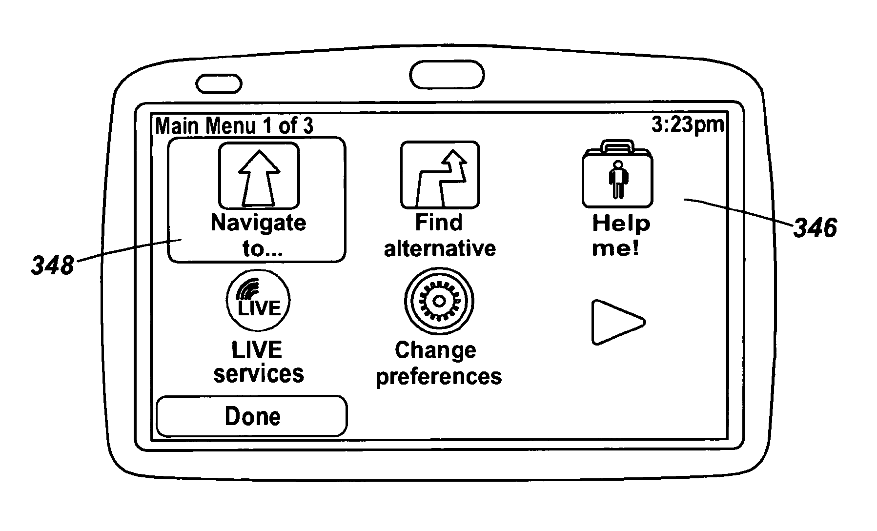
[0082]Preferred embodiments of the present invention will now be described with particular reference to a PND. It should be remembered, however, that the teachings of the present invention are not limited to PNDs but are instead universally applicable to any type of processing device that is configured to execute navigation software so as to provide route planning and navigation functionality. It follows therefore that in the context of the present application, a navigation device is intended to include (without limitation) any type of route planning and navigation device, irrespective of whether that device is embodied as a PND, a navigation device built into a vehicle, or indeed a computing resource (such as a desktop or portable personal computer (PC), mobile telephone or portable digital assistant (PDA)) executing route planning and navigation software.

[0083]It will also be apparent from the following that the teachings of the present invention even have utility in circumstances...


PUM


Abstract

The invention relates to a navigation device (200) comprising a display (240) for displaying a digital map to a user, a processor (210) configured to access digital map data and cause a digital map to be displayed to a user using the display, and a user interface operable by a user to enable the user to interact with the apparatus. The user interface is arranged to allow a user to provide, on the displayed digital map displayed to the user, an indication of a selected region present in the digital map. The processor (210) is arranged to determine digital map data relating to the selected region indicated by the user, and to carry out one or more operations relating to the selected region using the determined digital map data.

Description

FIELD OF THE INVENTION[0001]This invention relates to navigation or mapping apparatus, and methods of operating navigation or mapping apparatus. Illustrative embodiments of the invention relate to portable navigation devices (so-called PNDs), in particular PNDs that include Global Positioning System (GPS) signal reception and processing functionality. The invention is also applicable to a navigation apparatus which forms part of an integrated navigation system, e.g. an in-vehicle navigation system. Other embodiments relate, more generally, to any type of processing device that is configured to execute navigation or mapping software so as to provide route planning, and preferably also navigation, functionality, and methods of operating such devices. In particular, although not exclusively, the invention is concerned with the interaction between a user and the digital map data of such devices.BACKGROUND TO THE INVENTION[0002]The present invention is directed to a navigation or mapping...

Claims


Application Information

Patent Timeline
Patent Type & Authority Applications(United States)
IPC IPC(8): G01C21/36G06F3/0484
CPCG01C21/3484G01C21/3664G06F8/70G01C21/34G01C21/3626G06T11/60G06F3/0484G06F9/541
Inventor VAN SEGGELEN, ROBBOSCHKER, BREGHT RODERICK
Owner TOMTOM INT BV
Why Eureka
Try Eureka