Three-dimensional point cloud position data processing device, three-dimensional point cloud position data processing system, and three-dimensional point cloud position data processing method and program

a technology of point cloud position data and processing device, which is applied in the field of three-dimensional information measurement, can solve the problems of complex processing, long processing time, and inability to obtain three-dimensional point cloud position data of a part behind an object, and achieve the effect of efficient processing

Active Publication Date: 2014-02-06
KK TOPCON
View PDF0 Cites 70 Cited by
  • Summary
  • Abstract
  • Description
  • Claims
  • Application Information

AI Technical Summary

Benefits of technology

[0037]According to the first aspect of the present invention, matching planes between the two different viewpoints are calculated. The calculated matching planes determine the relationship between the first three-dimensional point cloud position data and the second three-dimensional point cloud position data. Thus, the positions can be adjusted to use the first and the second three-dimensional point cloud position data, which are obtained at the two viewpoints, in a common coordinate system. In this case, the enormous amounts of the first and the second three-dimensional point cloud position data need not be compared, whereby the processing is efficiently performed.

Problems solved by technology

In a case of obtaining three-dimensional point cloud position data by using a laser scanner, three-dimensional point cloud position data of a part behind an object cannot be obtained because the part is in the shadow of the object when seen from the laser scanner.
This processing is complicated and takes a long time to complete.
Since targets must be attached on the object in this method, for example, when a tall structure or the like is to be measured, work at high places is required, and stages for the work at high places are difficult to set.
Thus, there may be cases in which targets are not easily attached.

Method used


Image

  • Three-dimensional point cloud position data processing device, three-dimensional point cloud position data processing system, and three-dimensional point cloud position data processing method and program
  • Three-dimensional point cloud position data processing device, three-dimensional point cloud position data processing system, and three-dimensional point cloud position data processing method and program
  • Three-dimensional point cloud position data processing device, three-dimensional point cloud position data processing system, and three-dimensional point cloud position data processing method and program

Examples


first embodiment

1. First Embodiment

[0058]An example of a three-dimensional point cloud position data processing device using the present invention will be described with reference to figures hereinafter. The three-dimensional point cloud position data contain three-dimensional coordinate data of each measured point of an object in the following descriptions. The system of three-dimensional coordinates uses an orthogonal coordinate system or a polar coordinate system.

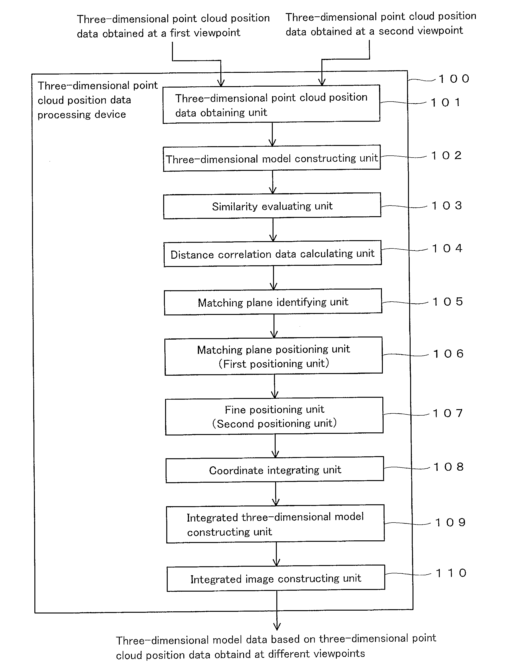
[0059]FIG. 1 shows a three-dimensional point cloud position data processing device 100 (hereinafter simply called “device 100”). The device 100 has a function of adjusting positions between first and second three-dimensional point cloud position data of an object, which are obtained at two different viewpoints. The device 100 also has a function of constructing a three-dimensional model of the object by integrally using the first and the second three-dimensional point cloud position data of the object, after the positions are adjusted. ...

second embodiment

2. Second Embodiment

[0137]For a method for determining matching planes by using a relative position between a target plane and the other plane, the most suitable method is using a correlation data group showing a positional relationship in a three-dimensional space between a target plane and each of the other planes of an object, which is described in the First Embodiment. However, alternatively, another method may also be used. Another example of the method for determining matching planes by using a relative position between a target plane and the other plane will be described hereinafter. In this example, in order to determine matching planes, parameters relating to the three-dimensional shape of an object are compared, and similarity therebetween is evaluated.

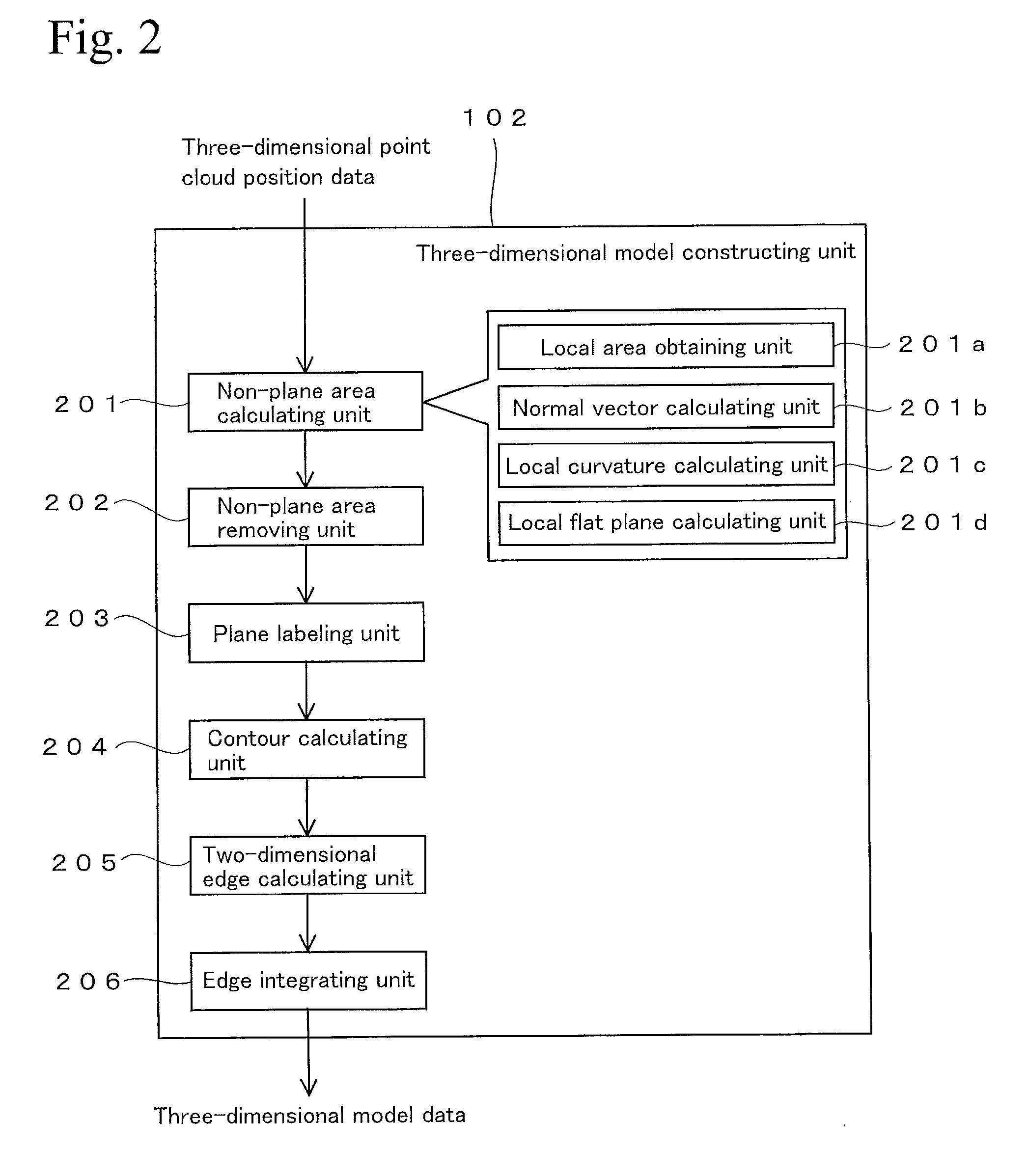
[0138]The three-dimensional model-constructing unit 102 in FIG. 1 performs processing based on the three-dimensional point cloud position data, whereby the appearance of the object can be understood from a set of plural plan...

third embodiment

3. Third Embodiment

[0151]A three-dimensional laser scanner that can process three-dimensional point cloud position data will be described hereinafter. In this example, the three-dimensional laser scanner emits distance measuring light (laser light) and scans with respect to an object and measures a distance to each target point on the object therefrom based on flight time of the laser light. Then, the three-dimensional laser scanner measures the emitted direction (horizontal angle and elevation angle) of the laser light and calculates three-dimensional coordinates of the target point based on the distance and the emitted direction. The three-dimensional laser scanner takes two-dimensional images (RGB intensity of each of the target points) that are photographs of the object and then forms three-dimensional point cloud position data by linking the two-dimensional images and the three-dimensional coordinates. Moreover, this three-dimensional laser scanner performs the processing that ...


PUM


Abstract

A technique is provided for efficiently process three-dimensional point cloud position data that are obtained at different viewpoints. A projecting plane is set in a measurement space as a parameter for characterizing a target plane contained in plural planes that form an object. The target plane and other planes are projected on the projecting plane. Then, a distance between each plane and the projecting plane is calculated at each grid point on the projecting plane, and the calculated matrix data is used as a range image that characterizes the target plane. The range image is also formed with respect to the other planes and with respect to planes that are viewed from another viewpoint. The range images of the two viewpoints are compared, and a pair of the planes having the smallest difference between the range images thereof is identified as matching planes between the two viewpoints.

Description

RELATED APPLICATIONS[0001]This application is a continuation of PCT / JP2012 / 059979 filed on Apr. 12, 2012, which claims priority to Japanese Application No. 2011-089483 filed on Apr. 13, 2011. The entire contents of these applications are incorporated herein by reference.BACKGROUND OF THE INVENTION[0002]1. Field of the Invention[0003]The present invention relates to a technique for measuring three-dimensional information.[0004]2. Description of Related Art[0005]A technique for constructing a three-dimensional model from three-dimensional point cloud position data of an object is known. In the three-dimensional point cloud position data, a two-dimensional image is linked with three-dimensional coordinates. That is, in the three-dimensional point cloud position data, data of a two-dimensional image of an object, plural measured points (point cloud) that are matched with the two-dimensional image, and positions (three-dimensional coordinates) of the measured points in a three-dimensiona...

Claims


Application Information

Patent Timeline
Patent Type & Authority Applications(United States)
IPC IPC(8): G06T7/00
CPCG06T7/0046G01B11/24G06T2207/10028G06T2207/30184G06T7/344
Inventor KITAMURA, KAZUOKOCHI, NOBUOITO, TADAYUKIOTANI, HITOSHI
Owner KK TOPCON
Why Eureka
Try Eureka