Methods of and apparatus for displaying map information

a map information and navigation device technology, applied in the field of navigation devices and methods and apparatus for displaying map information, can solve the problems of increasing the amount of geometry needed, not being able to display features in their current form, and reducing performance, so as to enhance the quality of the displayed image, enhance the displayed image, and enhance the image being displayed

Active Publication Date: 2014-07-03
TOMTOM INT BV
View PDF12 Cites 17 Cited by
  • Summary
  • Abstract
  • Description
  • Claims
  • Application Information

AI Technical Summary

Benefits of technology

[0165]A number of other techniques are preferably also used to enhance the quality of the displayed image in the embodiments of the present invention.
[0166]For example, in a preferred embodiment, the position (e.g. offset) of the rear “virtual” plane that the textures, etc., are, in effect, projected to in the embodiments of the present invention can be, and preferably is, varied in use (as the image is being displayed), e.g., so as to oscillate between two (or more) positions, e.g., on a frame-by-frame basis. This can be used, e.g., to give the effect of tide or waves when rendering water.
[0167]In a particularly preferred arrangement, the position (e.g. offset) of the rear “virtual” plane that the textures, etc., are, in effect, projected to in the embodiment

Problems solved by technology

However, the Applicants have recognised that tile-based methods in their current form are not so well suited for displaying features that are below (or above) the ground level such as water features (canals, rivers etc.) and/or lowered road segments or indeed any ‘open air’ feature that could be represented at lower or higher than ground level.
However, this greatly increas

Method used


Image

  • Methods of and apparatus for displaying map information
  • Methods of and apparatus for displaying map information
  • Methods of and apparatus for displaying map information

Examples


first embodiment

[0282]This embodiment again uses two textures and uses the same method for view dependent displacement of a second texture map as described in the However, the nature of the two textures is different, as is the combining operation of the first texture map and the second texture map.

second embodiment

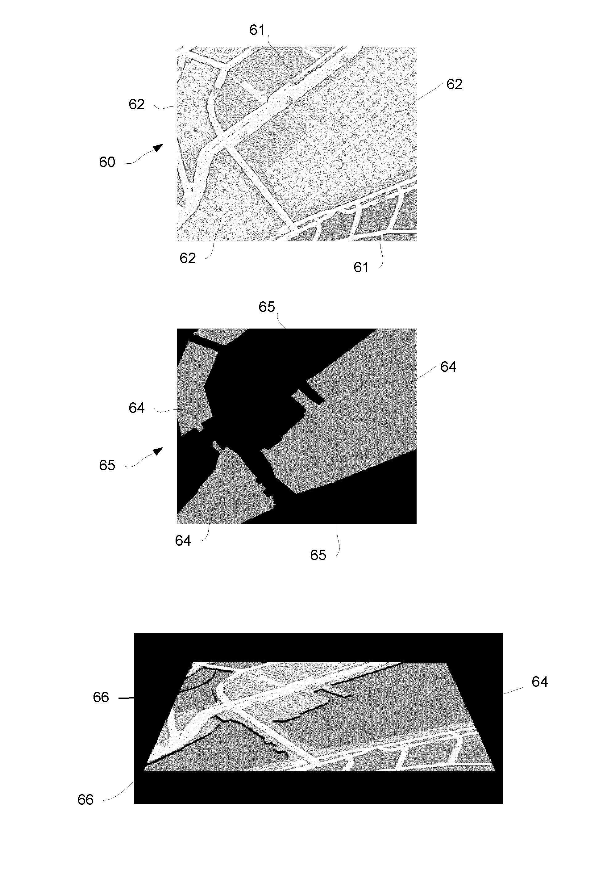
[0283]In this second embodiment, the first texture is a colour map that shows all the map features to be displayed.

[0284]The second texture map is in the form of a “modulation map” in the form of a ‘dark map’, which contains values between 0.0 and 1.0, which are multiplied with the first texture, darkening it (modulating its intensity) only where a value lower than 1.0 appears. (Thus, in this embodiment, a multiplication instead of an alpha blending operation is used to combine the first and second textures.) The dark map second texture is configured to contain values lower than 1.0 at places corresponding to map feature edges (e.g. water edges).

[0285]FIG. 9 illustrates this. FIG. 9a shows the colour map first texture 90. FIG. 9b shows the dark map second texture 91. FIG. 9c shows the image 92 produced by combining the first texture 90 and the second texture 91. Again, the effect is that different level features are shown as having darker edges, thereby giving the impression of dept...

third embodiment

[0303]This third embodiment works by calculating an output pixel color based on comparing a first look-up value in a source texture (e.g. that is on the ground plane) with a second look-up value from the same source texture from a displaced position. Depending on the comparison (e.g. a first look-up value representing water and a second look-up value being next to the water), a corresponding modulated output pixel value is (selectively) produced.

[0304]Thus, in this embodiment the first texture is a colour map showing all the desired map features, and the second texture it is combined with is a displaced version of that colour map first texture.

[0305]The displacement of the first, source texture to form the second texture can be obtained by exactly the same methods as explained above in relation to the first embodiment.

[0306]For example, the displaced version of the first texture can be obtained by projecting, according to the camera view, the first texture coordinates to a rear “vir...


PUM


Abstract

In a system that uses tile-based road network rendering for displaying map information to a user, a tile is rendered for display by rendering a tile 10 by using a first texture comprising one or more map features to be displayed for the tile of the map in combination with a second texture to apply a texture to a graphics primitive or primitives representing the tile such that at least one map feature 11, such as a water feature, being displayed on the tile 10 is bordered by a border region 24 that represents a border to that map feature. In this way, a more visually appealing depiction of the map feature 11 can be achieved.

Description

FIELD OF THE INVENTION[0001]This invention relates to navigation devices and to methods and apparatus for displaying map information, such as navigation maps. Illustrative embodiments of the invention relate to portable navigation devices (so-called PNDs), in particular PNDs that include Global Positioning System (GPS) signal reception and processing functionality. Other embodiments relate, more generally, to any type of processing device that is configured to display map information and / or to execute navigation software so as to provide route planning, and preferably also navigation, functionality.BACKGROUND TO THE INVENTION[0002]Portable navigation devices (PNDs) that include GPS (Global Positioning System) signal reception and processing functionality are well known and are widely employed as in-car or other vehicle navigation systems.[0003]In general terms, a modern PNDs comprises a processor, memory (at least one of volatile and non-volatile, and commonly both), and map data st...

Claims


Application Information

Patent Timeline
IPC IPC(8): G06T17/05G06T15/50G06T15/04
CPCG06T15/50G06T17/05G06T15/04G01C21/367
Inventor BOSCHKER, BREGHT RODERICKMEINDS, KORNELIS
Owner TOMTOM INT BV
Why Eureka
Try Eureka