Data quality assessment and real-time evaluation of GPS probe data

a data quality and real-time evaluation technology, applied in the field of analysis of gps data, can solve the problems of no current methodology for evaluating how much data in a bulk dataset of raw probe data, no existing framework in the existing art for determining the value of a data point, and no current methodology for determining how much additional value each additional vendor (n+1) provides for improving the analysis, so as to improve the assessment of roadway conditions and generate additional revenue streams

Active Publication Date: 2015-01-01
ITERIS INC
View PDF0 Cites 18 Cited by
  • Summary
  • Abstract
  • Description
  • Claims
  • Application Information

AI Technical Summary

Benefits of technology

[0010]It is therefore one objective of the present invention to provide a framework for evaluating how much data in a bulk dataset of raw probe data provided by each vendor is pertinent for determining traffic information, such as speed. It is also an objective of the present invention to provide a framework for determining the value of a data point in a dataset that can be used to comparatively evaluate different vendors. Another objective is a framework for determining how much incremental value is provided by additional vendors for improving the assessment of roadway conditions like traffic flow. Still another objective is to provide a framework for real-time evaluation that can be used to predict traffic conditions and generate further revenue streams from processing of raw probe data.

Problems solved by technology

Ingests of raw probe data include data points of which many will not be relevant to the purchaser, and there is no current methodology for evaluating how much data in a bulk dataset of raw probe data is pertinent from the collection of information provided by each vendor.
Similarly, there is no existing framework in the existing art for determining the value of a data point in a dataset that can be used to comparatively evaluate different vendors.
Once a subscription to bulk raw probe data from a set (N) of vendors is undertaken, however, there is no current methodology for determining how much further value each additional vendor (N+1) provides for improving the analysis of roadway conditions like traffic flow from speed.
In other words, there is no known framework in existence that permits traffic engineers to judge whether the accuracy of data extracted from a GPS dataset can be improved by additional subscriptions to vended probe data.
Additionally, there is no current methodology for performing a real-time evaluation of raw probe data to enable a prediction of data quality and realize a distribution of value extracted from an analysis of the quality of data points in a dataset.

Method used


Image

  • Data quality assessment and real-time evaluation of GPS probe data
  • Data quality assessment and real-time evaluation of GPS probe data
  • Data quality assessment and real-time evaluation of GPS probe data

Examples


Embodiment Construction

[0018]In the following description of the present invention reference is made to the exemplary embodiments illustrating the principles of the present invention and how it is practiced. Other embodiments will be utilized to practice the present invention and structural and functional changes will be made thereto without departing from the scope of the present invention.

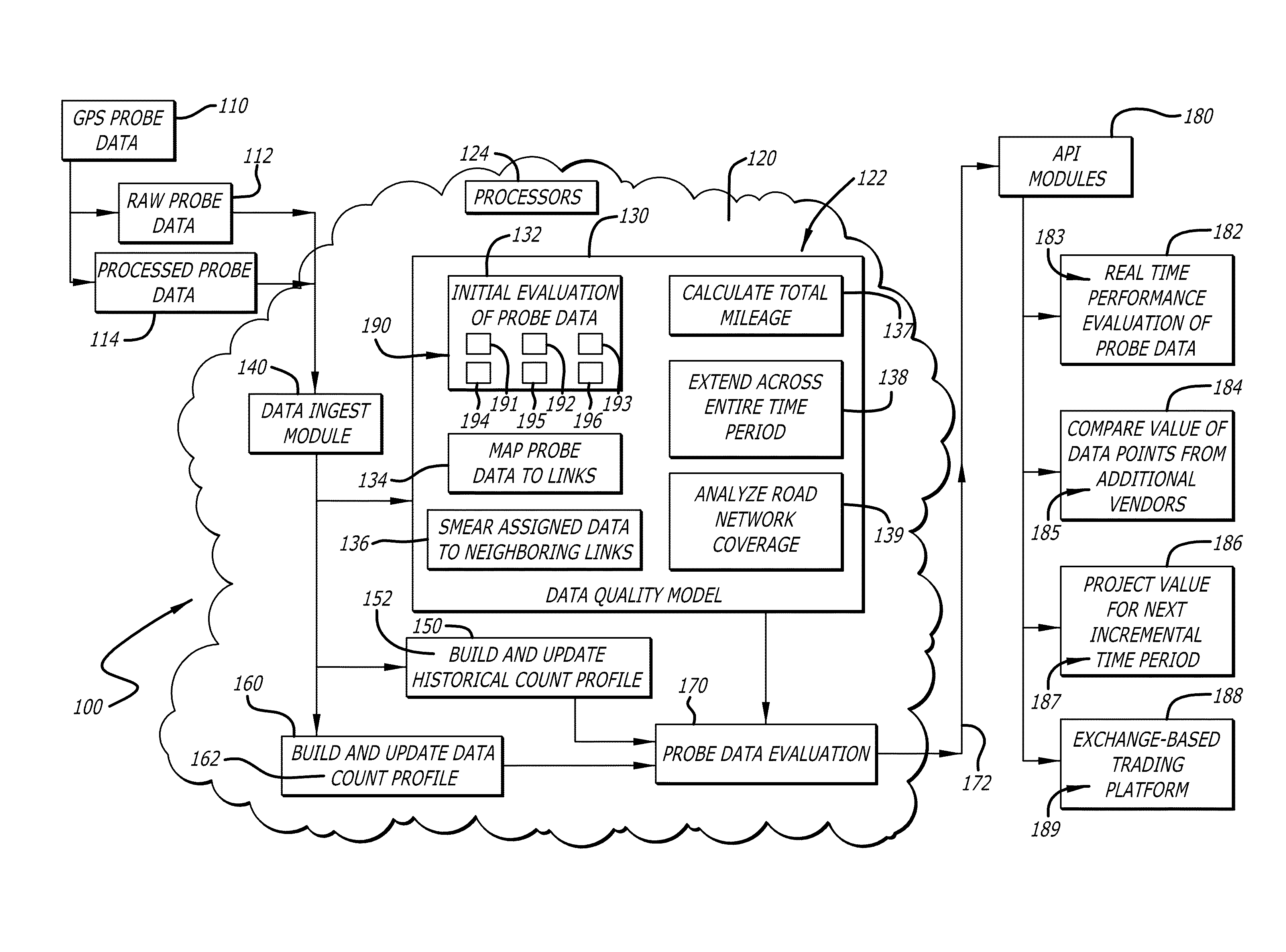
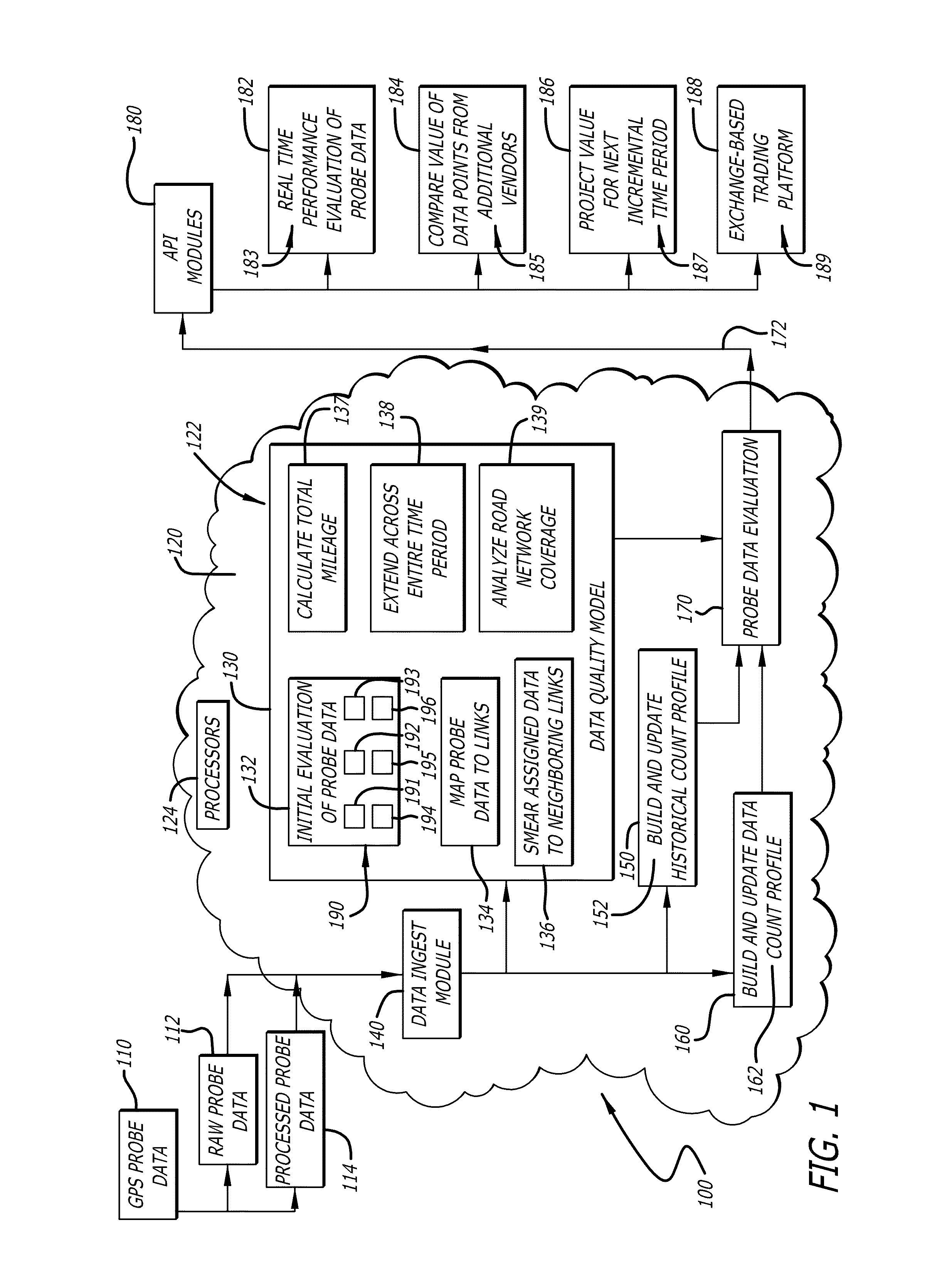
[0019]The present invention discloses a GPS data quality assessment and real-time evaluation tool 100, as shown for example in FIG. 1. In the present invention, quality of data 110 collected from GPS systems in its “raw”, or unprocessed, form 112 is assessed using several criteria. As noted above, raw probe data 112 is a collection of bulk data points in a GPS dataset, in contrast to probe data 114 that has been processed so as to be associated with traffic speed on a roadway network. The GPS data quality assessment and real-time evaluation tool 100 is configured to determine, in one aspect of the present invention, th...


PUM


Abstract

Quality assessment of probe data collected from GPS systems is performed by a system and method of determining a value of data points provided by different vendors of such data. Incoming raw probe data is initially analyzed for removal of extraneous data points, and is then mapped to roadway links and smoothed out. The resulting output is processed to determine the coverage value of data provided by a given vendor and enable a comparison between different vendors. Such a model of probe data processing also enables an evaluation of a contribution of further vendors of raw probe data to an existing dataset. Additionally, a real-time performance evaluation of continually-ingested probe data includes building historical and data count profiles, and generating output data represented by a number of data points for a specific distance within a geo-box representing a geographical area, to project a value of raw probe data for a next incremental time period.

Description

CROSS-REFERENCE TO RELATED PATENT APPLICATIONS[0001]This patent application claims priority to U.S. provisional application 61 / 841,452, filed on Jul. 1, 2013, the contents of which are incorporated in their entirety herein.FIELD OF THE INVENTION[0002]The present invention relates to analyzing GPS data. Specifically, the present invention relates to a system and method of assessing the relevancy of bulk GPS probe data, determining the contribution of additional probe data from different vendors, and performing real-time evaluations of the probe data for vertical commercial applications.BACKGROUND OF THE INVENTION[0003]Data generated by geographical position systems (GPS) is currently sold in bulk, by the number of data points per day or per month. Generally, this data may be packaged in different ways—for example, in the form of “raw” or unprocessed probe data points, or in the form of processed probe data that reflects traffic speed on a roadway network. Ingests of raw probe data in...

Claims


Application Information

Patent Timeline
Patent Type & Authority Applications(United States)
IPC IPC(8): G08G1/052
CPCG08G1/052G08G1/0112G08G1/0133G08G1/0141
Inventor KWON, JAIMYOUNGPETTY, KARL F.KURZHANSKIY, ALEX A.MOYLAN, ANDREW J.
Owner ITERIS INC
Why Eureka
Try Eureka