System for mapping and tracking ground targets

a mapping and target technology, applied in the field of space monitoring, can solve the problems of difficult to obtain various types of imagery data for a particular location, difficult to correlate imagery data after it has been processed, and high cost of resource mapping activities or search and rescue activities, etc., to facilitate autonomous control, efficient and cost-effective

Active Publication Date: 2015-07-23
PILLAY VENKATESHWARA
View PDF6 Cites 50 Cited by
  • Summary
  • Abstract
  • Description
  • Claims
  • Application Information

AI Technical Summary

Benefits of technology

[0009]The proposed invention facilitates autonomous control by providing a system consisting of UAVs and Low Earth Orbit (LEO) Earth Observation Satellites which communicates with these unmanned aerial devices through the use of at least one data relay satellite in Geostationary Equatorial Orbit (GEO), to image, process and output image data. The proposed system performs the above mentioned mapping or reconnaissance operations in a more efficient and cost effective manner, compared to conventional systems. The proposed system serves as an improvement to manual tasking and control of mapping operations using UAVs or satellites, which are currently not coordinated, and limited by ground station location or availability.
[0010]According to one aspect of the present invention there is provided a system for autonomously mapping and tracking ground targets at any location of interest involving unmanned aerial vehicles (UAV) and / or SAR satellites in low earth orbits with on board sensors for acquiring imagery data for the ground targets and a user control center (108) for executing a plurality of operations for controlling the UAVs and SAR satellites and processing various sensory inputs to optimally map or track the ground targets, the system comprises: at least one user control center in operative communication with one or more data relay satellites in Geostationary Equatorial Orbit (GEO), the data relay satellites in Geostationary Equatorial Orbit (GEO) in operative communication with the UAVs and / or SAR satellites to obtain various types of imagery data for the ground targets and simultaneously dynamically reconfiguring flight path and the on-board sensors pointing requirements to facilitate the optimal mapping and tracking of the ground targets; and the data relay satellites in GEO establishing target specific constant communication based on the user control center and it requires the UAVs and SAR satellites for continuous feedback and control through the UAVs and SAR satellites for the ground target mapping or tracking irrespective of their distances from the User control center.

Problems solved by technology

In manned airborne surveillance for resource mapping or ground target identification, the resource mapping activities or search and rescue activities can be costly and restrictive due to limited availability of human pilots that cater to these activities.
Also, UAVs or satellites used for resource mapping or ground target identification are often operated independently by various ground stations around the world, making it challenging to correlate the imagery data after it has been processed.
It is currently difficult to obtain various types of imagery data for a particular location at the same time-stamp.
As a result, there are often delays in receiving raw imagery data at a remote ground station, followed by additional delays involved in transferring the data from the remote ground station to the mission control centre for data processing.
UAVs need to be constantly in communication range with a ground station or terminal during operations, which means that its operational flight path is restricted by the ground station location.

Method used


Image

  • System for mapping and tracking ground targets
  • System for mapping and tracking ground targets
  • System for mapping and tracking ground targets

Examples


Embodiment Construction

[0026]The detailed description set forth below in connection with the appended drawings is intended as a description of exemplary embodiments and is not intended to represent the only form in which the embodiments may be constructed and / or utilized. The description sets forth the functions and the sequence for constructing the exemplary embodiments. However, it is to be understood that the same or equivalent functions and sequences may be accomplished by different embodiments that are also intended to be encompassed within the scope of this disclosure.

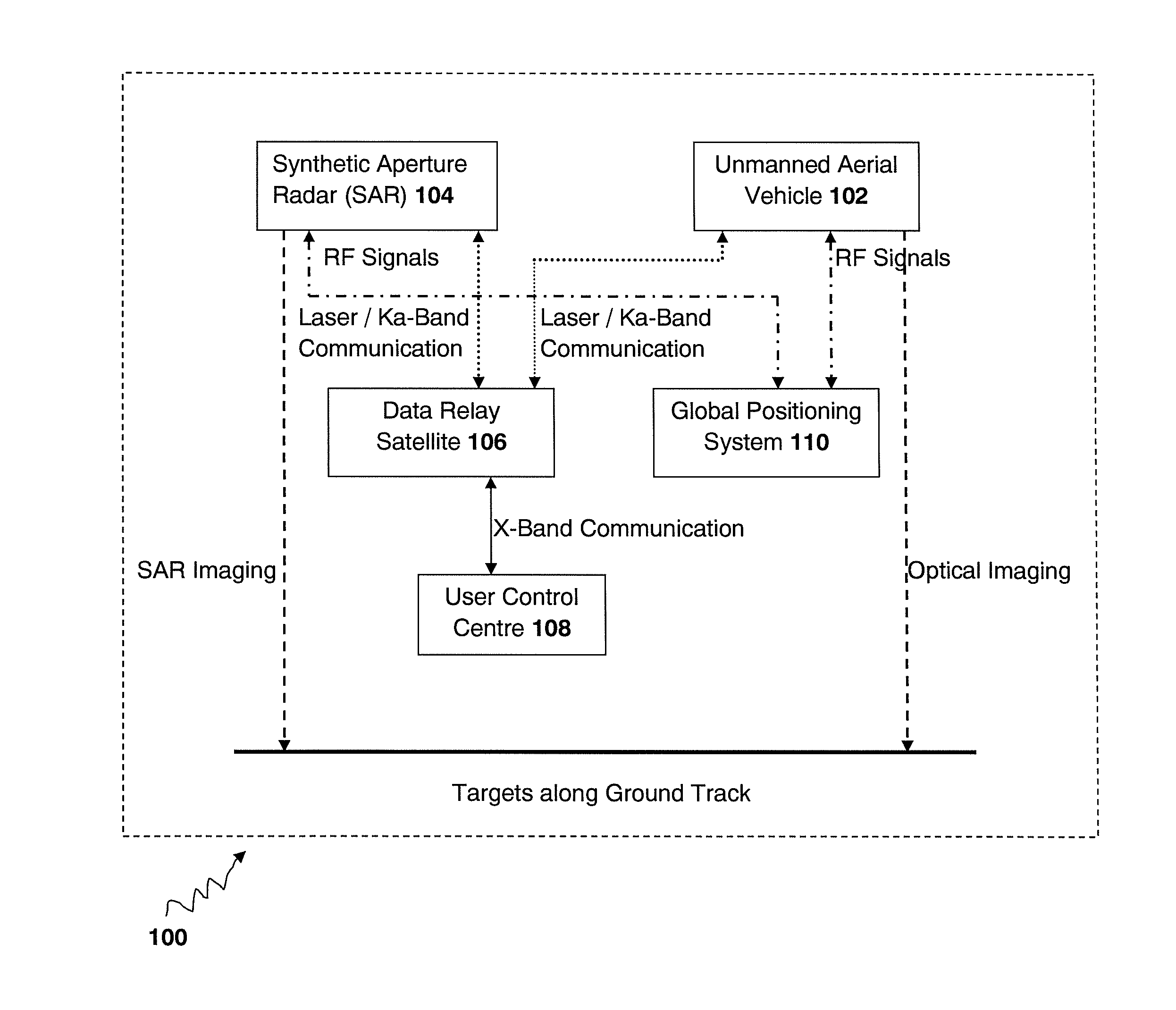
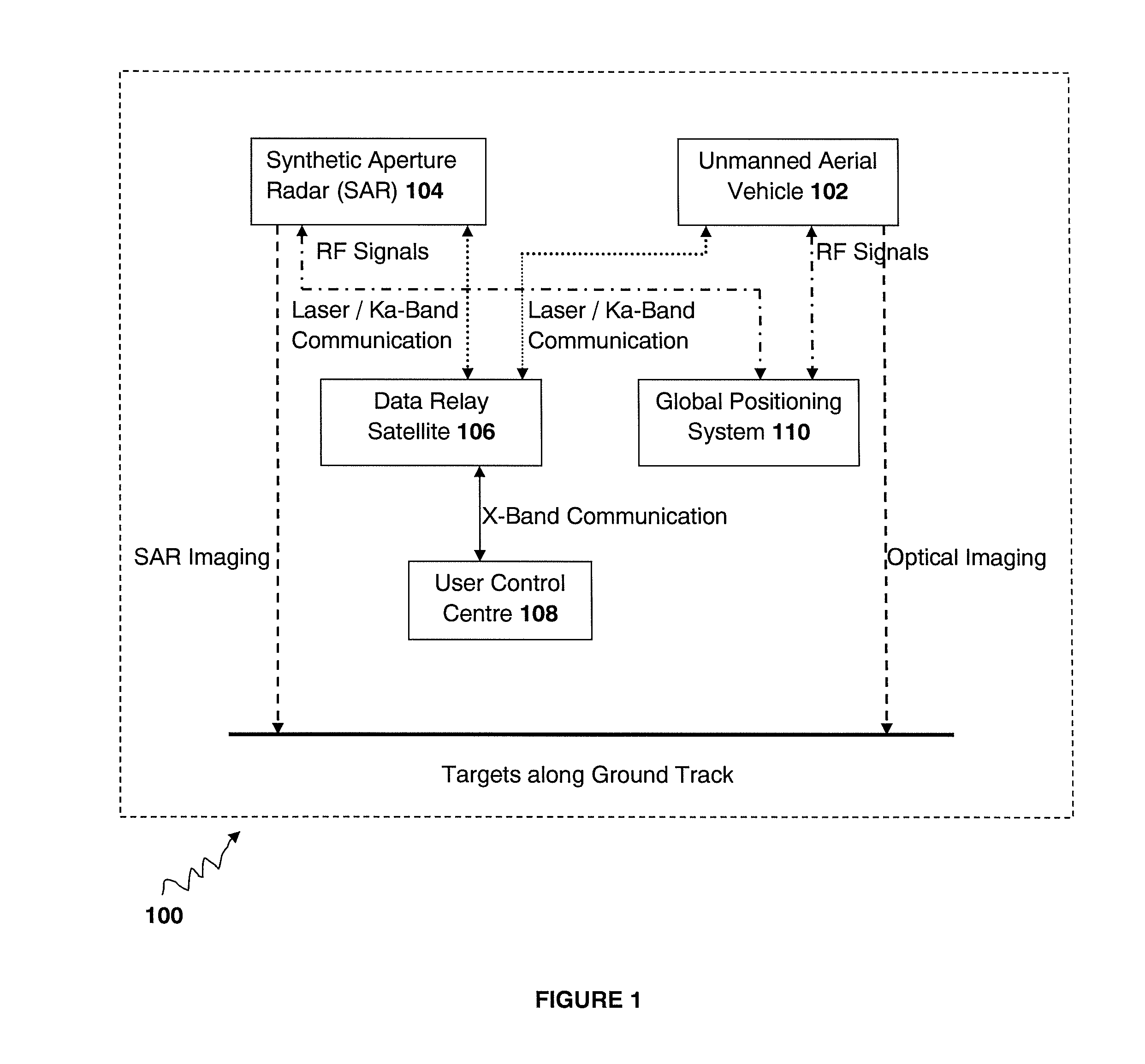
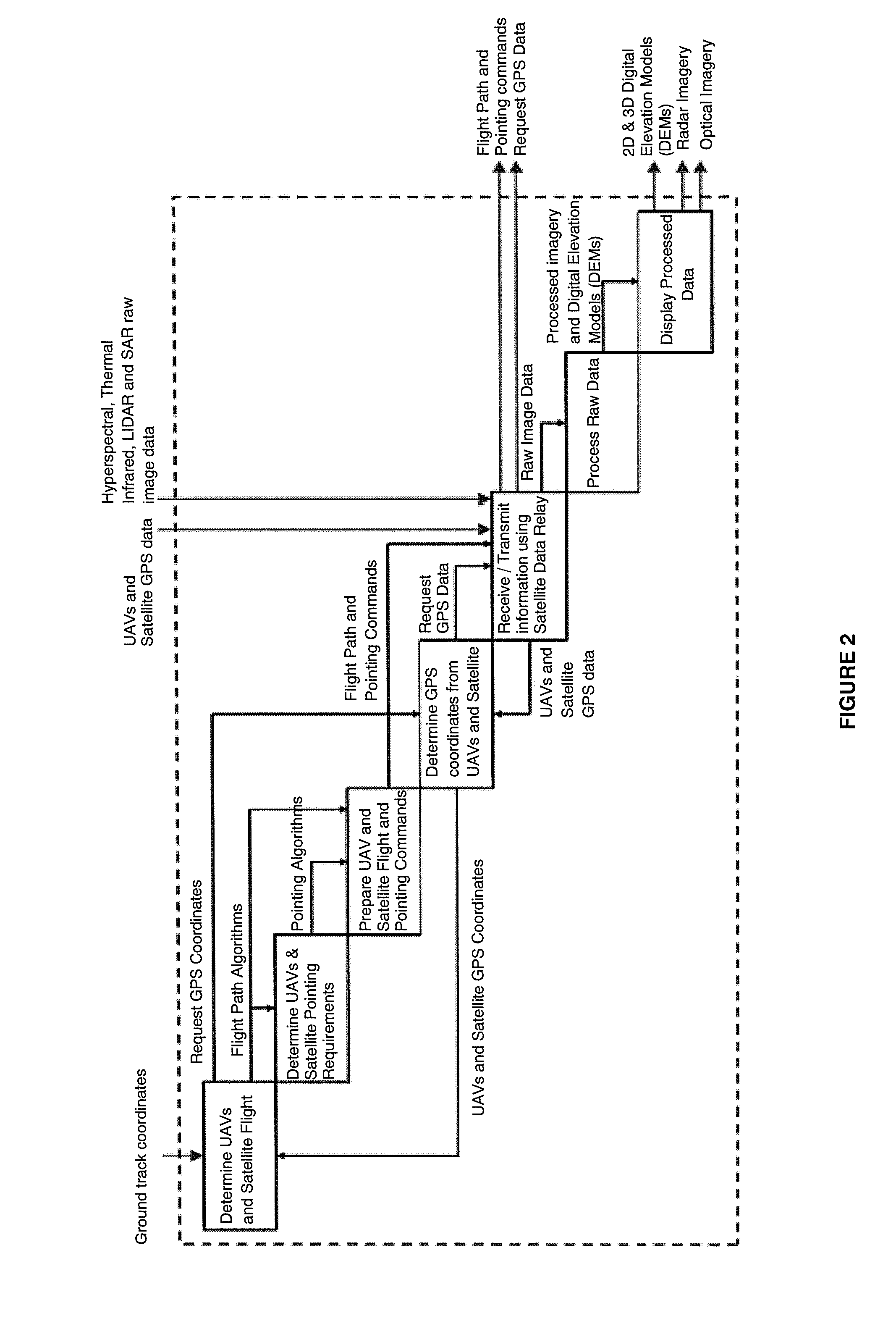
[0027]The conventional monitoring systems involving aerial devices require ground operators to be continuously available to command and control the aerial devices. Moreover, the conventional monitoring systems require the ground stations to be within the aerial devices' communication antenna's line of sight to receive tasking commands or perform data downlink operations. Thus, the flight path and transmission of images or surveillance ...


PUM


Abstract

A system for autonomously mapping and tracking of ground targets at a location of interest has been disclosed. The system comprises at least one user control center in operative communication with one or more data relay satellites in Geostationary Equatorial Orbit (GEO), the data relay satellites in operative communication with one or more UAVs and/or SAR satellites with on-board different imaging sensors to obtain various types of imagery data from the ground targets. The data relay satellites target specific constant communication with the user control center and the UAVs and SAR satellites for continuous feedback and control. Moreover, the system process all raw data obtained from the UAVs and SAR satellites to produce 2D and 3D Digital Elevation Models (DEMs) and high resolution images, which are displayed on the user control center and/or selected mobile handheld devices.

Description

FIELD OF THE INVENTION[0001]The present invention relates to the field of aerial and space monitoring. Particularly, this invention relates to a control system which can autonomously map and / or track ground targets at any location of interest using unmanned aerospace assets.BACKGROUND OF THE INVENTION[0002]Today, mapping or tracking ground targets at any location of interest from any remote or distant location is particularly useful for resource mapping, pipeline monitoring, intelligence gathering or supporting disaster response teams. In manned airborne surveillance for resource mapping or ground target identification, the resource mapping activities or search and rescue activities can be costly and restrictive due to limited availability of human pilots that cater to these activities. There are some surveillance systems for resource mapping or ground target identification which can be found which involve unmanned aerial assets.[0003]United States Patent Application 20100269143 dis...

Claims


Application Information

Patent Timeline
Patent Type & Authority Applications(United States)
IPC IPC(8): G01S13/90G01S17/86G01S17/89
CPCG01S13/90G01S17/89G01S7/003G01S7/04G01S7/51G01S13/86G01S13/865G01S17/86
Inventor PILLAY, VENKATESHWARA
Owner PILLAY VENKATESHWARA
Why Eureka
Try Eureka