Method and apparatus for controlling electrical power usage based on exact sun elevation angle and measured geographical location

a technology of exact sun elevation angle and electrical power usage, applied in the direction of electric variable regulation, process and machine control, instruments, etc., can solve the problems of complex quadruple integral that cannot be easily admitted to conventional numerical analysis, and achieve accurate control of electrical activity, save energy, and smooth transition in ambient lighting

Active Publication Date: 2015-11-26
LONESTAR INVENTIONS LP
View PDF3 Cites 18 Cited by
  • Summary
  • Abstract
  • Description
  • Claims
  • Application Information

AI Technical Summary

Benefits of technology

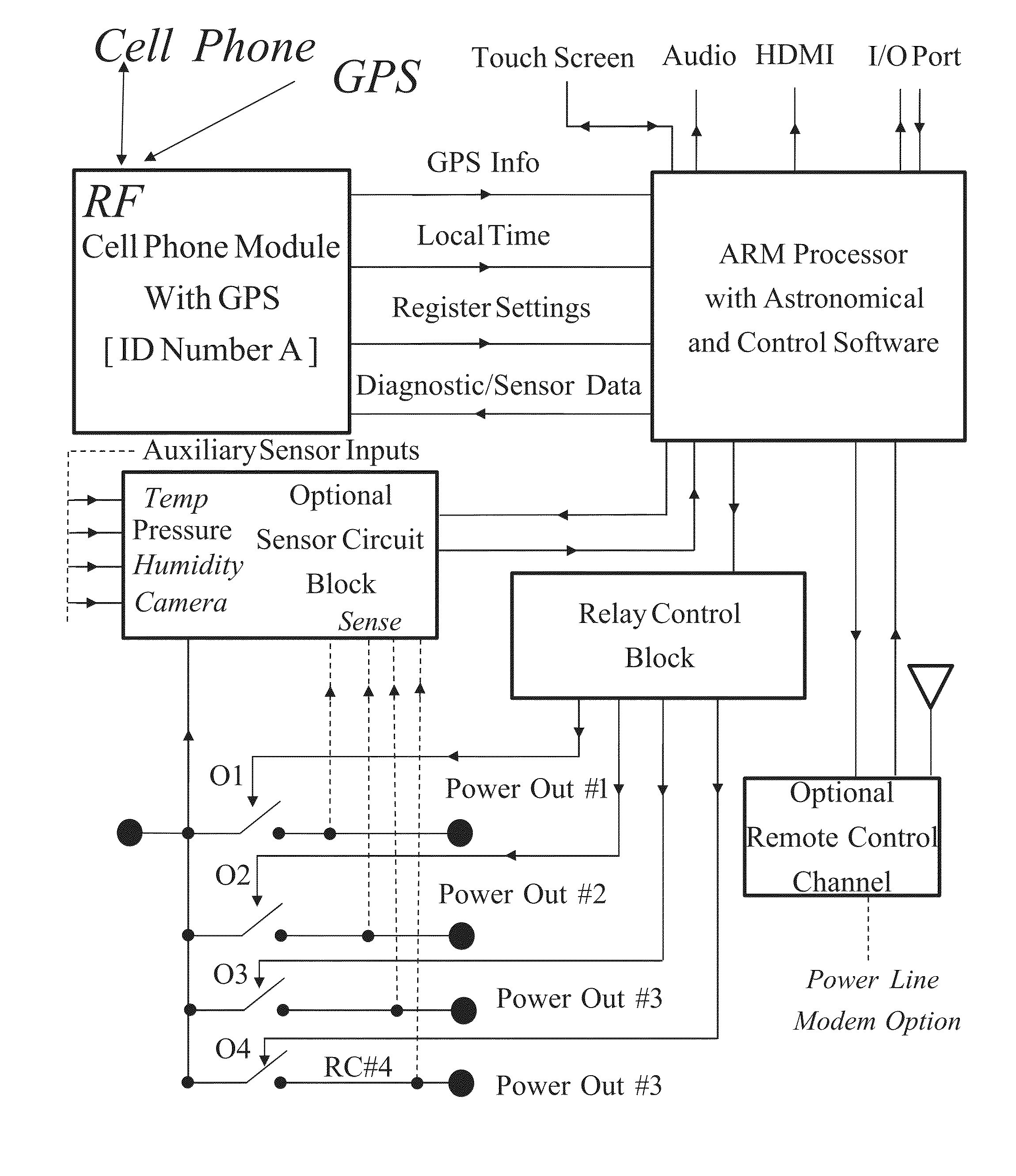
[0065]According to the invention, a method and apparatus are provided to accurately control electrical activity, such as artificial lighting, using accurate geographical location of longitude, latitude and altitude, as well as accurate date and time, in order to activate such electrical activity only during needed periods of actual terrestrial darkness, particularly as it relates to sun elevation. The method involves accurate, real-time calculation of sun elevation relative to geographical location so that natural lighting characteristics such as natural light spectrum and intensity can be matched to artificial lighting in order to provide a smooth transition in ambient lighting and to save energy. An apparatus according to the invention comprises a global positioning system (GPS) element for determining latitude, longitude, altitude, date and time and a calculation element for determining sun elevation angle accurately. A specific embodiment of the apparatus is a completely mobile and stand-alone unit, requiring only desired sun elevation angle inputs from the user for controlling electrical switches in a control system. Since electrical “on” and “off” states of any desired electrical functions are only controlled by the sun elevation or a function associated with it, this invention has particular advantages. Some are related to ease of use, such as no requirements for date and time adjustments and no initialization for a local system clock. The apparatus works anywhere on earth. Since the time and date is obtained via a GPS function, there are no issues related to time initialization requirements associated with power outages and arbitrary time adjustment, such as local daylight saving practices.
[0069]The invention is useful for achieving annual energy savings, on the order of 2%-18%, depending on the latitude and altitude compared to existing controls that may be in place. By using the very accurate sun elevation and azimuth calculation routines, such as those provided in the “OEA Astronomical and Navigational Utilities” again from OEA International, Inc., as described in [7], U.S. Patent Publication US 2013 / 0116967, published May 9, 2013, along with the derived “critical sun elevation angle” controlling the artificial illumination in a house, office, parking lot, street or highway, such a savings in energy consumption for lighting can result. The energy savings using this methodology as a function of latitude has been verified by the “OEA Astronomical and Navigational Utilities”. This is a very significant energy saving without causing any comfort or safety issues and can be implemented very quickly and easily according to the invention.
[0070]The ability to quantitatively represent energy savings is another key point of this invention. It can be shown that the complete hardware with a GPS module costs less than $200.00, which pays for itself almost immediately for a great majority of its applications. In consideration of the national renewable energy initiative percentage goal is 20% by 2020 in the USA, a significant portion of this figure can be achieved very quickly by the energy savings that can be realized with the implementation of a system according to this invention.

Problems solved by technology

The analysis involves a complicated quadruple integral that does not easily admit to conventional numerical analysis.

Method used


Image

  • Method and apparatus for controlling electrical power usage based on exact sun elevation angle and measured geographical location
  • Method and apparatus for controlling electrical power usage based on exact sun elevation angle and measured geographical location
  • Method and apparatus for controlling electrical power usage based on exact sun elevation angle and measured geographical location

Examples


Embodiment Construction

[0177]This invention is now described in connection with the experimental and theoretical efforts that verify the validity of the invention.

2.0. Introduction

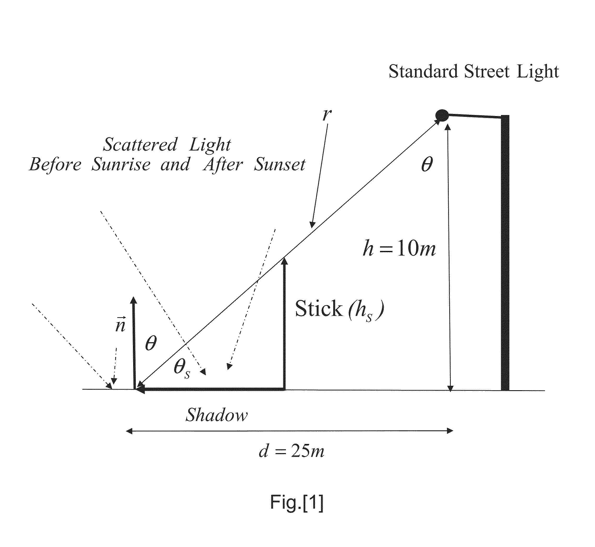
[0178]The energy-saving nature of this invention is the key of focus for purposes of illustration. Energy savings can depend upon relating the sun elevation angle to a comfortable visibility, a visibility that is sufficient for driving and pedestrian traffic without artificial illumination. In the first part that follows, two subjective methods for defining this relationship are described, both based on surveying a large number of people. The result of these subjective methods shows that a “critical sun elevation angle” can be defined when the sun elevation angle is in the range of 3° to 4° below the horizon for any date and location. This range of elevation angles is almost independent of the weather conditions, including thick cloud cover, and provides lighting that is comfortable enough for safe driving conditions with no art...


PUM


Abstract

A method and apparatus are provided to control artificial lighting using accurate geographical location, date and time, in order to activate such electrical activity only during needed periods of actual terrestrial darkness related to sun elevation. Accurate, real-time calculation of sun elevation relative to geographical location and date / time allow natural lighting characteristics such as natural light spectrum and intensity to be matched to artificial lighting, in order to provide a smooth transition in ambient lighting and to save energy. An apparatus according to the invention comprises a global positioning system (GPS) element for determining latitude, longitude, altitude, date and time and a calculation element for determining sun elevation angle accurately. A specific embodiment requires only desired sun elevation angle inputs from the user for controlling electrical switches in a control system.

Description

CROSS-REFERENCES TO RELATED APPLICATIONS[0001]NOT APPLICABLESTATEMENT AS TO RIGHTS TO INVENTIONS MADE UNDER FEDERALLY SPONSORED RESEARCH AND DEVELOPMENT[0002]NOT APPLICABLEREFERENCE TO A “SEQUENCE LISTING,” A TABLE, OR A COMPUTER PROGRAM LISTING APPENDIX SUBMITTED ON A COMPACT DISK[0003]NOT APPLICABLEBACKGROUND OF THE INVENTION[0004]This invention relates to applications of accurate measurement of geographical location including elevation as for example obtained by GPS information for use in control and more particularly in terrestrial spectral matching for control of infrastructure artificial lighting systems. This invention involves a mathematically rigorous proof of validity of the conclusions underlying embodiments of the invention. The present application contains a tutorial in support of the technology underlying the invention.[0005]Many events and functions in daily life are controlled by natural light, and in particular by the sun's elevation angle. An example can be found i...

Claims


Application Information

Patent Timeline
Patent Type & Authority Applications(United States)
IPC IPC(8): H05B37/02
CPCH05B37/0209G01S3/782G01S19/14G01J2001/4266H05B47/10H05B47/11H05B47/14Y02B20/40
Inventor AKCASU, OSMAN ERSEDAKCAY, IBRAHIMUSLU, IBRAHIM ONURAKCASU, JACQUELINE MAHAN
Owner LONESTAR INVENTIONS LP
Why Eureka
Try Eureka