Vehicle positioning by map matching as feedback for ins/GPS navigation system during GPS signal loss

a technology of vehicle positioning and map matching, applied in traffic control systems, navigation instruments, instruments, etc., can solve problems such as jamming, rf interference and multipath problems, and inability to determine the correct current vehicle position, so as to accurately estimate the current vehicle position

Inactive Publication Date: 2016-05-26
ALPINE ELECTRONICS INC
View PDF8 Cites 79 Cited by
  • Summary
  • Abstract
  • Description
  • Claims
  • Application Information

AI Technical Summary

Benefits of technology

[0022]Another aspect of the present disclosure is directed to a vehicle positioning apparatus for a navigation system established on a smartphone. The vehicle positioning apparatus detects a timing when the vehicle enters the tunnel and immediately starts the map matching operation and feedbacks the results of the map matching operation to accurately estimate the current vehicle position by implementing the various operational steps defined in the method of vehicle positioning noted above.
[0023]As has been described above, according to the vehicle...

Problems solved by technology

However, the INS cannot provide high accuracy at long ranges, because inertial sensors are subject to errors that tend to accumulate over time.
Since the map and navigation system relies on GPS signals from GPS satellites, it is susceptible to loss of signals, jamming, RF (radio frequency) interference and multipath problems depending on specific surroundings of the map and navigation system.
However, as noted above, since the ...

Method used


Image

  • Vehicle positioning by map matching as feedback for ins/GPS navigation system during GPS signal loss
  • Vehicle positioning by map matching as feedback for ins/GPS navigation system during GPS signal loss
  • Vehicle positioning by map matching as feedback for ins/GPS navigation system during GPS signal loss

Examples


Embodiment Construction

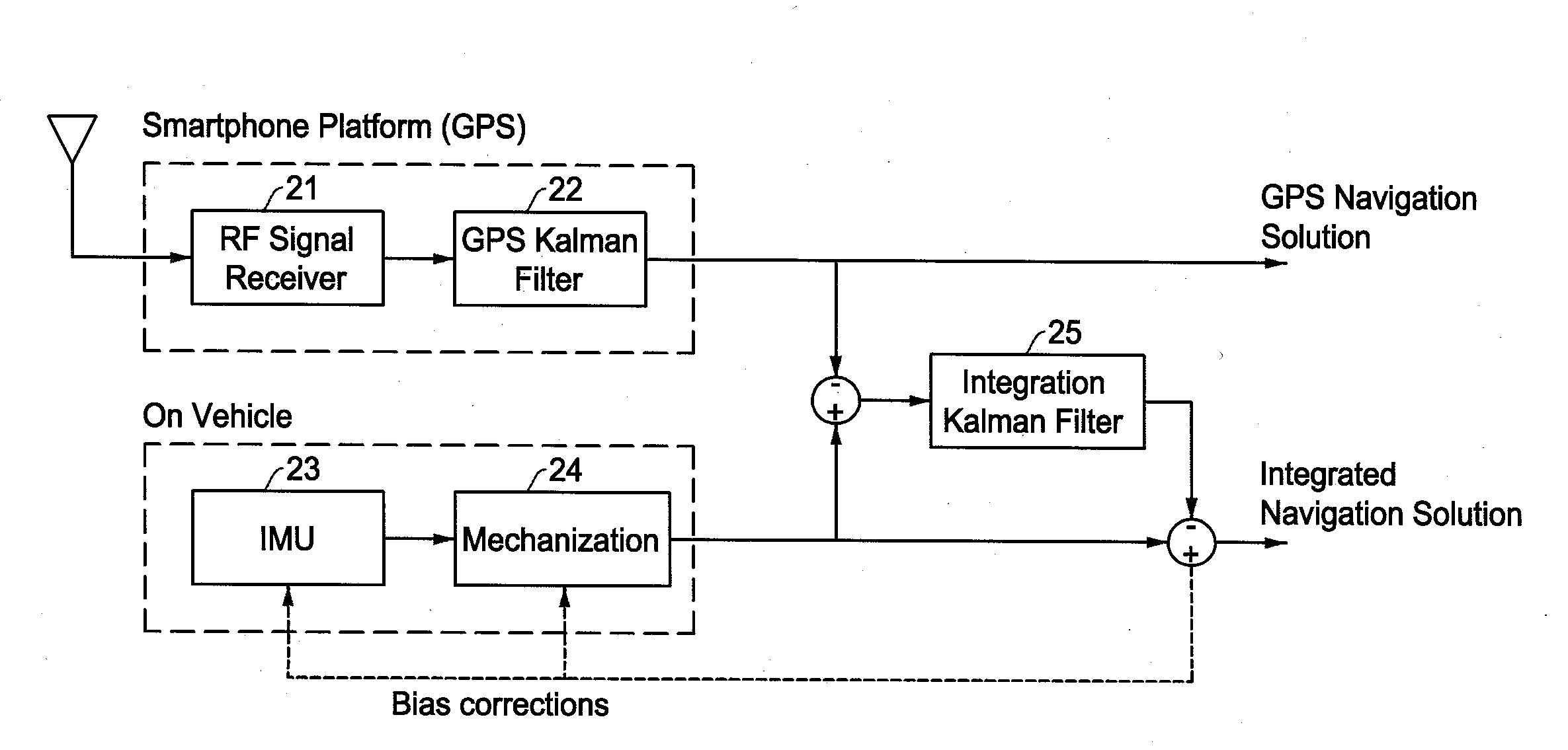
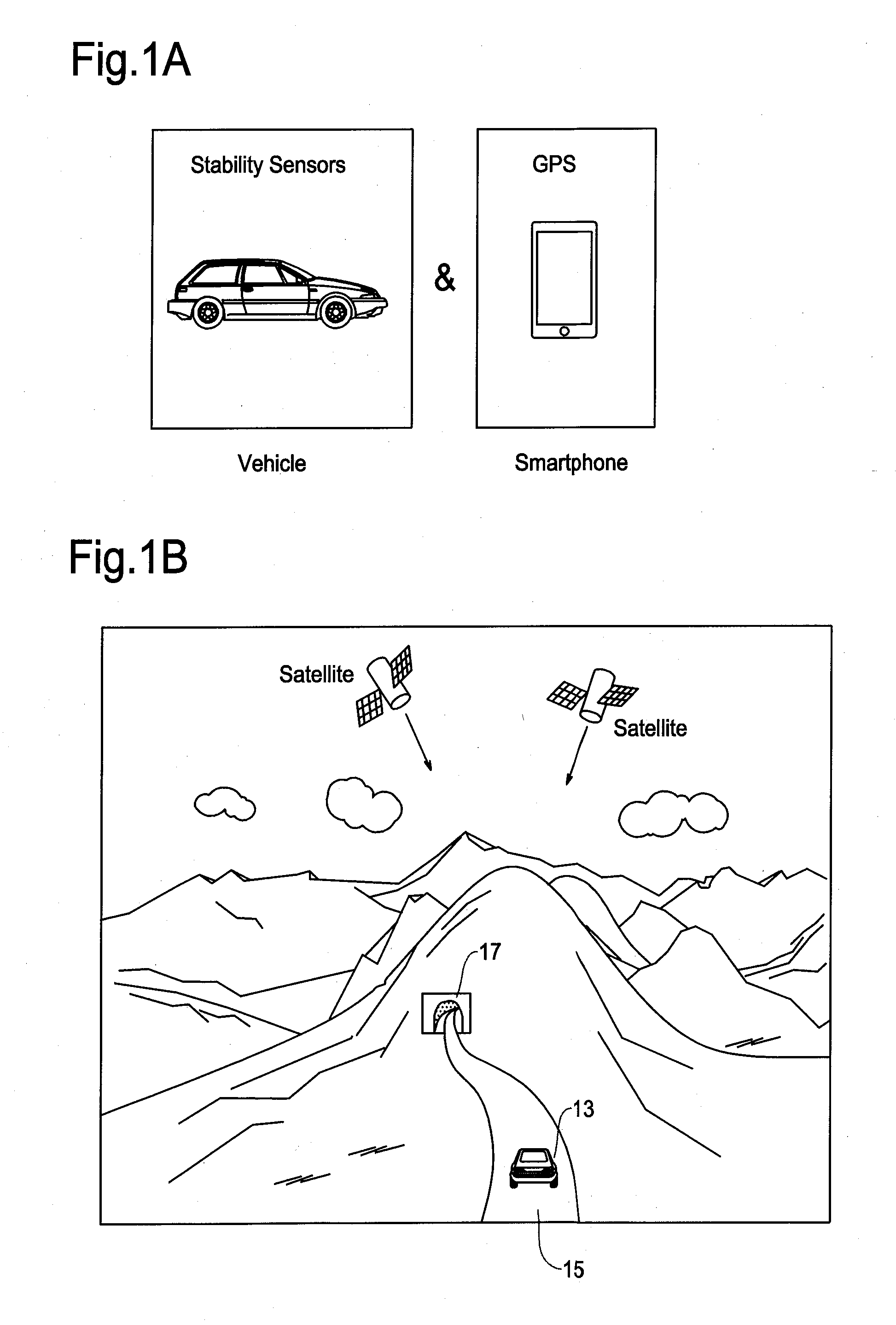
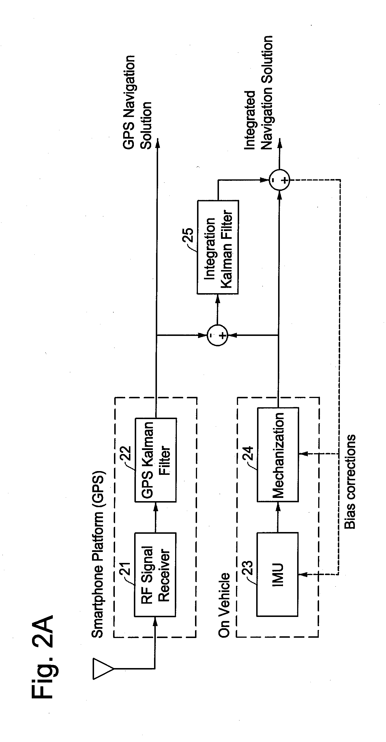
[0033]Various embodiments will be described hereinafter in detail with reference to the accompanying drawings. The present method of enhanced vehicle positioning is advantageously used in a navigation system where a smartphone with a GPS function is mounted on a vehicle having sensors for stability control, i.e., an off-board navigation system running on a smartphone. Within the context of the present disclosure, a smartphone is a mobile phone with more advanced computing and communication capability than basic mobile phones. A recent smartphone is equipped with various intelligent functions including a map and navigation function that accurately calculates geographical location by analyzing information contained in Global Positioning System (GPS) signals received from GPS satellites.

[0034]As noted above, some of current vehicles include processors, various sensors, and wired and / or wireless network in order to improve driving safety through vehicle stability control and accident pr...


PUM


Abstract

A method and apparatus of vehicle positioning uses map matching as feedback for an integrated navigation system where a map and navigation system is coupled with an inertial navigation system (INS) using low-precision vehicle sensors when the vehicle passes through a tunnel or other area suffering from GPS signal loss. The method and apparatus operates to detect whether the vehicle has reached an entry point of a tunnel, and if so, immediately starts a map matching operation to match the current vehicle position with a road link of the tunnel. The current position determined by the map matching operation is feedbacked to an integration Kalman filter thereby correcting errors caused by the vehicle sensors. The method and apparatus resumes the normal navigation operation including GPS navigation as soon as it detects that the vehicle is out of the tunnel.

Description

FIELD OF THE INVENTION[0001]This invention relates to a method and apparatus of vehicle positioning by using a smartphone positioning system and vehicle sensors made of low-precision Micro Electro Mechanical Sensors (MEMS). More particularly, this invention relates to a method and apparatus of vehicle positioning by using a map matching technology as feedbacks for compensating the positioning errors in an integrated INS / GPS navigation system for traveling an area in which sufficient Global Positioning System (GPS) signals are unavailable.BACKGROUND OF THE INVENTION[0002]Today's high end vehicle includes processors, various sensors, and wired / wireless network to enable improved safety through a vehicle stability control and accident protection. For example, vehicle stability is controlled by detecting and reducing skidding (loss of traction) involved in a cornering action, brake action on wet surfaces of road, abrupt acceleration of a vehicle, etc. Sensors installed in a vehicle for ...

Claims


Application Information

Patent Timeline
IPC IPC(8): G01C21/30G01S19/13G01C21/16
CPCG01C21/30G01S19/13G01C21/165G01S19/49G01S5/015
Inventor REN, MING
Owner ALPINE ELECTRONICS INC
Why Eureka
Try Eureka