Learning Signs From Vehicle Probes

a technology of vehicle probes and signs, applied in the field of learning signs from vehicle probes, can solve problems such as inability to timely report a major, data entry errors, and data input delays, and achieve the effect of avoiding data entry errors

Active Publication Date: 2016-06-16
HERE GLOBAL BV
View PDF0 Cites 47 Cited by
  • Summary
  • Abstract
  • Description
  • Claims
  • Application Information

AI Technical Summary

Problems solved by technology

Also, online traffic reporting resources may suffer from infrequent updates, data entry errors, or delayed data input.
These factors cause the traffic reporter to fail to timely report a major traffic incident or congestion, or continue to report an incident or congestion well after the incident or congestion has been cleared.
Tall buildings may partially block GPS signals.
Additionally, the illustrations are merely representational and may not be drawn to scale.

Method used


Image

  • Learning Signs From Vehicle Probes
  • Learning Signs From Vehicle Probes
  • Learning Signs From Vehicle Probes

Examples


Embodiment Construction

[0014]The following embodiments include identifying road signs along a roadway segment from vehicle probe data.

[0015]As used herein, a “road” or “roadway” may refer to any traveling lane or pathway that may be capable of being monitored for traffic congestion / incident detection, or may become capable of being monitored for traffic congestion / incident detection in the future (e.g., a highway, city street, bus route, train route, walking / biking pathway, waterway).

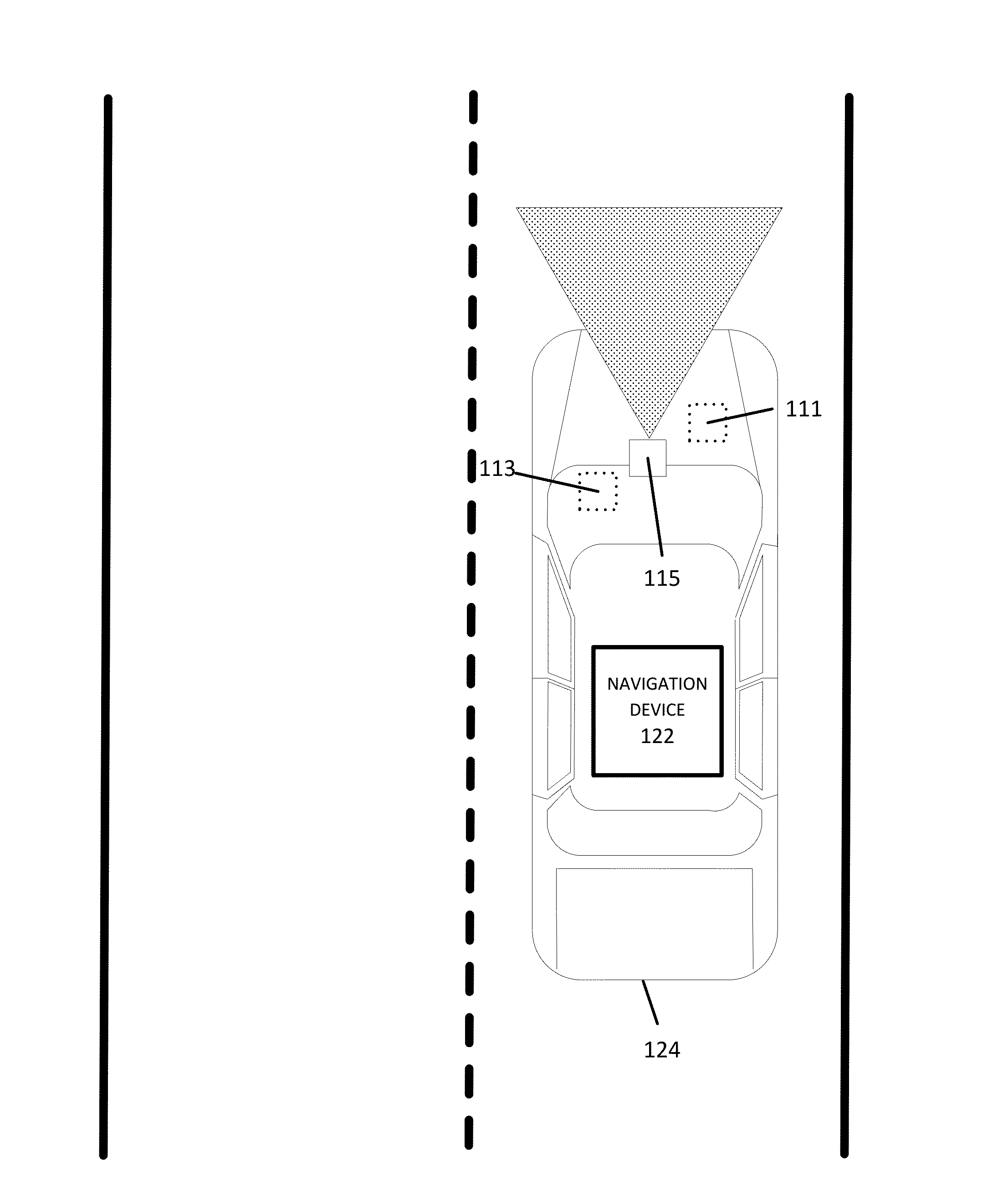
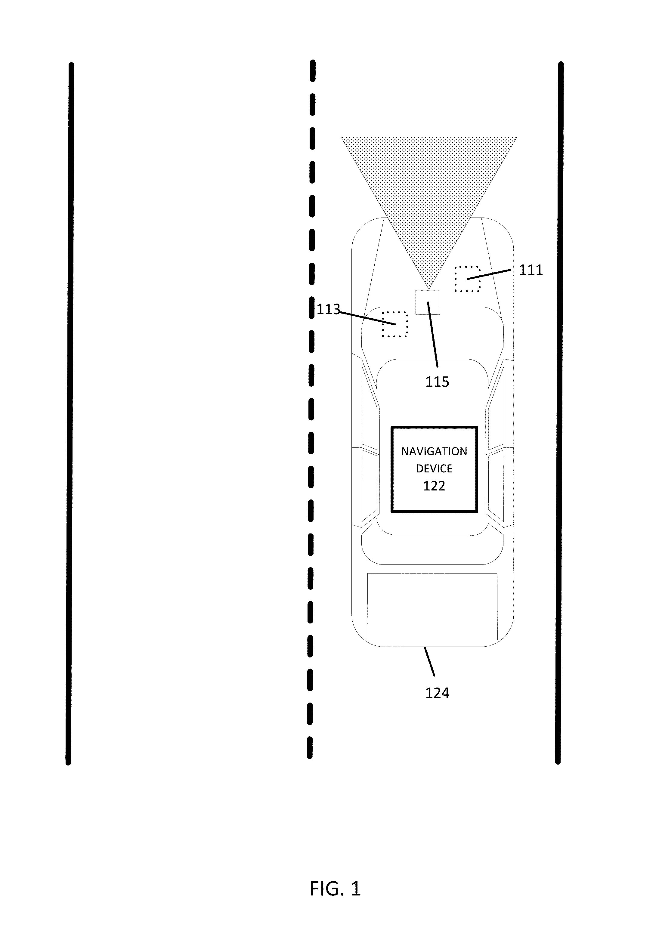
Collecting Vehicle Probe Data

[0016]Road signs for a selected road segment may be determined through the collection, reporting, and analysis of vehicle probe data from a vehicle or a plurality of vehicles. In certain embodiments, for each vehicle, the vehicle probe data is collected by at least one vehicle sensor. The vehicle sensors are configured to identify the surroundings and the location of the probe vehicle (e.g., car, truck, motorcycle, bicycle, bus). The sensors may include Global Positioning System (GPS) identificati...


PUM


Abstract

Systems, methods, and apparatuses are disclosed for identifying road signs along a roadway segment from vehicle probe data. Probe data is received from vehicle sensors at a road segment, wherein the probe data includes observed static objects along the road segment. Road signs are identified within the observed static objects of the probe data using a logistic regression algorithm. The geographic location of the identified road signs are determined using a linear regression algorithm.

Description

FIELD[0001]The following disclosure relates to identifying road signs along a roadway segment from vehicle probe data.BACKGROUND[0002]Traffic reporters may rely on traffic information made available by government agencies. Also, online traffic reporting resources may suffer from infrequent updates, data entry errors, or delayed data input. These factors cause the traffic reporter to fail to timely report a major traffic incident or congestion, or continue to report an incident or congestion well after the incident or congestion has been cleared. Therefore, providing real time, accurate traffic information, such as for use in a navigation system (and, in particular, for an autonomous vehicle), is a continuing effort.[0003]To enable automated driving, route validation and planning beyond a vehicle's sensor range is important. For example, it is important to accurately and timely detect low latency road condition changes and abnormalities such as lane closures and slipperiness of the r...

Claims


Application Information

Patent Timeline
Patent Type & Authority Applications(United States)
IPC IPC(8): G05D1/02G01C21/34G05D1/00G06V10/764
CPCG05D1/0088G01C21/3407G05D1/0221G05D2201/0212G05D1/0231G08G1/0112G08G1/09623G08G1/096725G08G1/0129G08G1/0141G08G1/096716G08G1/096758G08G1/096791G06V20/582G06V10/764G06F18/2413G06F18/2453G01C21/3841
Inventor CHEN, XINMA, DIMA, XIANGOSTROVSKIY, ROMANZHUKOV, VLADZOU, XIAOTAO
Owner HERE GLOBAL BV
Why Eureka
Try Eureka