Address/latitude and longitude converting device and geographical information system using the same

a technology of converting device and geographical information system, applied in the direction of digital data information retrieval, geographical information database, instruments, etc., can solve the problems of long time required for visualizing and displaying data in designated areas, poor operability, low conversion speed, etc., to narrow down the retrieval range, efficient search, and high speed

Active Publication Date: 2016-11-10
WINGARC 1ST
View PDF4 Cites 6 Cited by
  • Summary
  • Abstract
  • Description
  • Claims
  • Application Information

AI Technical Summary

Benefits of technology

[0012]The present invention has been made in order to solve the problems and has an object to enable conversion from address information into latitude and longitude information at a high speed in real time depending on a request given from an application utilizing the latitude and longitude information without generating an intermediate table requiring maintenance by a batch processing.
[0014]According to the present invention having the structure described above, information to be used for converting the address information into the latitude and longitude information is not prepared in a form of a conventional conversion table obtained by causing each address and each latitude and longitude to perform one-to-one correspondence to each other but a form of the tree structure and is stored in the high-speed accessible memory. When actually converting the address information into the latitude and longitude information, therefore, it is possible to efficiently search the latitude and longitude information corresponding to the given address information therefrom by proceeding a retrieval while tracing the address tree information of the tree structure in order from a parent node to a child node to narrow down a retrieval range. In addition, in the present invention, the address tree information is stored in the high-speed accessible memory. As compared with the related art in which access is given to a conversion table stored in a disk, therefore, it is possible to perform a retrieval at a high speed.
[0015]From the foregoing, even if the conversion from the address information into the latitude and longitude information is performed when a request from an application utilizing the latitude and longitude information is given, the conversion can be completed in a very short time. Therefore, it is possible to implement remarkably high response performance. Consequently, it is not necessary to previously generate an intermediate table in order to avoid inferiority in a response as in the related art. According to the present invention, thus, it is possible to perform the conversion from the address information into the latitude and longitude information at a high speed in real time depending on the request given from the application utilizing the latitude and longitude information without generating the intermediate table requiring maintenance by a batch processing.

Problems solved by technology

Referring to the conventional geocoding using the API, however, there is a problem in that a conversion speed is very low, such as several cases to several tens cases per second and a long time is taken for a processing.
For example, in the case in which data having addresses in an area designated by a user is to be visualized and displayed visually by visualization software by taking, as a target, a database having an enormous number of data stored from a business system or the like, a very long time is required for visualizing and displaying data in the designated area.
When a large number of data are included in the designated area, a time of several tens minutes to several hours is sometimes required for converting the address information into the latitude and longitude information by the geocoding, resulting in very poor operability.
For this reason, there is a problem in that data registered newly in the database or data having an address changed cannot be utilized by referring to a position from an application until the maintenance of the intermediate table is completed.

Method used


Image

  • Address/latitude and longitude converting device and geographical information system using the same
  • Address/latitude and longitude converting device and geographical information system using the same
  • Address/latitude and longitude converting device and geographical information system using the same

Examples


Embodiment Construction

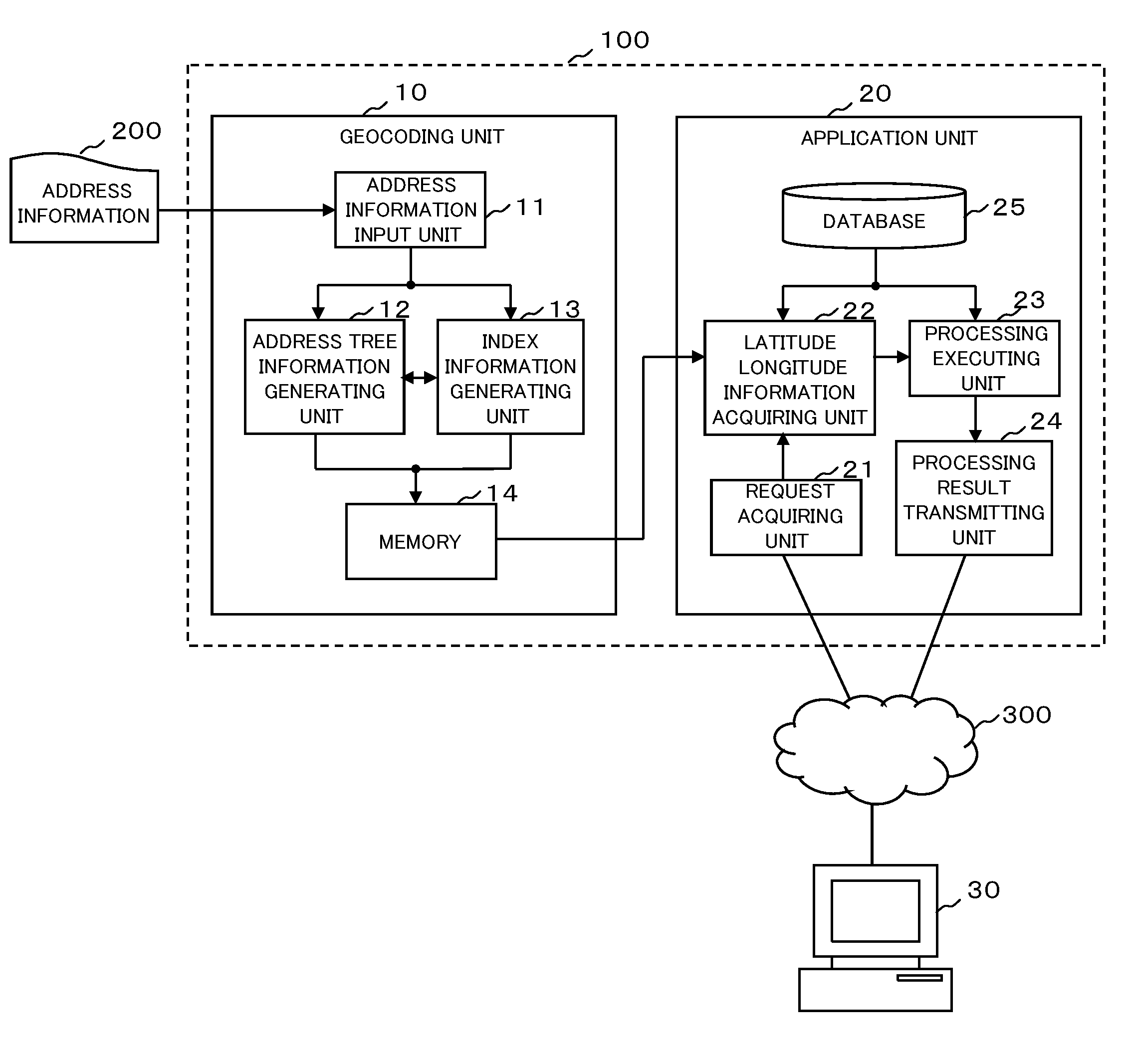
[0020]An embodiment of the present invention will be described below with reference to the drawings. FIG. 1 is a diagram showing an example of a structure of a geographical information system executing an address / latitude and longitude converting device according to the present embodiment. As shown in FIG. 1, a geographical information system 100 according to the present embodiment includes a geocoding unit 10 and an application unit 20.

[0021]The geocoding unit 10 serves to convert address information into latitude and longitude information and is configured from a server device, for example. The geocoding unit 10 includes an address information input unit 11, an address tree information generating unit 12, an index information generating unit 13 and a memory 14. Each of functional blocks of the address information input unit 11, the address tree information generating unit 12 and the index information generating unit 13 is configured from software installed in a server device, for ...


PUM


Abstract

By converting address information 200 input to a geocoding unit 10 into a tree structure formed hierarchically in an administrative district, generating address tree information obtained by associating latitude and longitude information with at least a node of the lowest layer in each branch of the tree structure and storing the address tree information thus generated in a high-speed accessible memory 14 to proceed a retrieval while tracing the address tree information in order from a parent node to a child node to narrow down a retrieval range, it is possible to efficiently search latitude and longitude information corresponding to given address information therefrom and to perform a retrieval at a higher speed as compared with the related art in which access is given to a conversion table stored in a disk.

Description

TECHNICAL FIELD[0001]The present invention relates to an address / latitude and longitude converting device and a geographical information system using the same and more particularly is suitably used for an address / latitude and longitude converting device for converting geographical information about an address into coordinate information about a latitude and longitude and a geographical information system for performing a predetermined processing by using latitude and longitude information converted by the address / latitude and longitude converting device.BACKGROUND ART[0002]Conventionally, there is known the technology for converting geographical information such as an address or a place name into coordinate information about a latitude and longitude (for example, see Patent Documents 1 and 2). The technology is referred to as geocoding and is widely used practically in an application using a map. For example, there is provided a system obtained by combining the geocoding and the geo...

Claims


Application Information

Patent Timeline
Patent Type & Authority Applications(United States)
IPC IPC(8): G06F17/30
CPCG06F17/30327G06F16/2246G06F16/29G01C21/26
Inventor KATO, TAIYOSHIMAZAWA, KOYOSHIHARA, KOSUKE
Owner WINGARC 1ST
Why Eureka
Try Eureka