Wildfire aerial fighting system utilizing lidar

a technology of aerial fighting and lidar, applied in the field of wildfire aerial fighting system utilizing lidar, can solve the problems of reducing the visualization of the area in darkness, affecting the effectiveness of firefighting decisions, and affecting the safety of residents, so as to achieve rapid and effective firefighting tactical execution, enhance situational awareness, and reduce the effect of firefighting

Inactive Publication Date: 2017-04-13
DOTEN LEONARD E
View PDF3 Cites 5 Cited by
  • Summary
  • Abstract
  • Description
  • Claims
  • Application Information

AI Technical Summary

Benefits of technology

[0031]Another object of the present invention is to provide a display which combines wildfire theatre elevation, vegetation and fuel density data with active burning wildfire data to more fully depict to command personnel where a wildfire is burning, and what terrain conditions exist surrounding the active burn area, to support effective firefighting decisions.
[0032]Another object of the present

Problems solved by technology

The destructiveness of wildfire to lives, property and the environment is often grave.
While this is a good vantage point, such personnel can be hampered in viewing the wildfire theatre in that smoke and/or clouds/haze can obscure sight, darkness diminishes visualization of the area, and some attributes of the area, such as combustible fuel density can be difficult to determine.
Also, even with binoculars the ability to “zoom in” on particular sub-locations is limited.
Beginning at the time of the first report, time constraints exist and a highly dynamic, chaotic event i

Method used


Image

  • Wildfire aerial fighting system utilizing lidar
  • Wildfire aerial fighting system utilizing lidar
  • Wildfire aerial fighting system utilizing lidar

Examples


Embodiment Construction

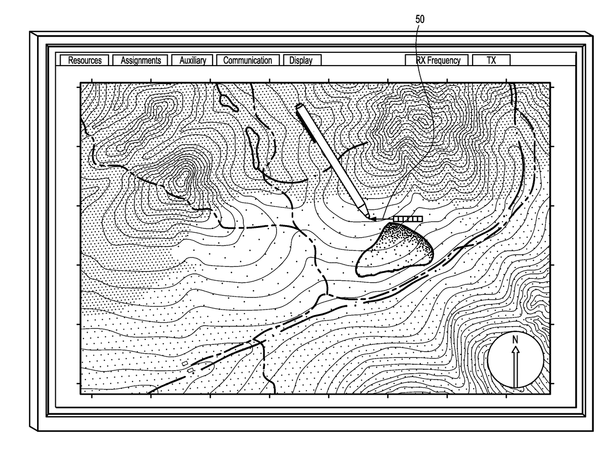
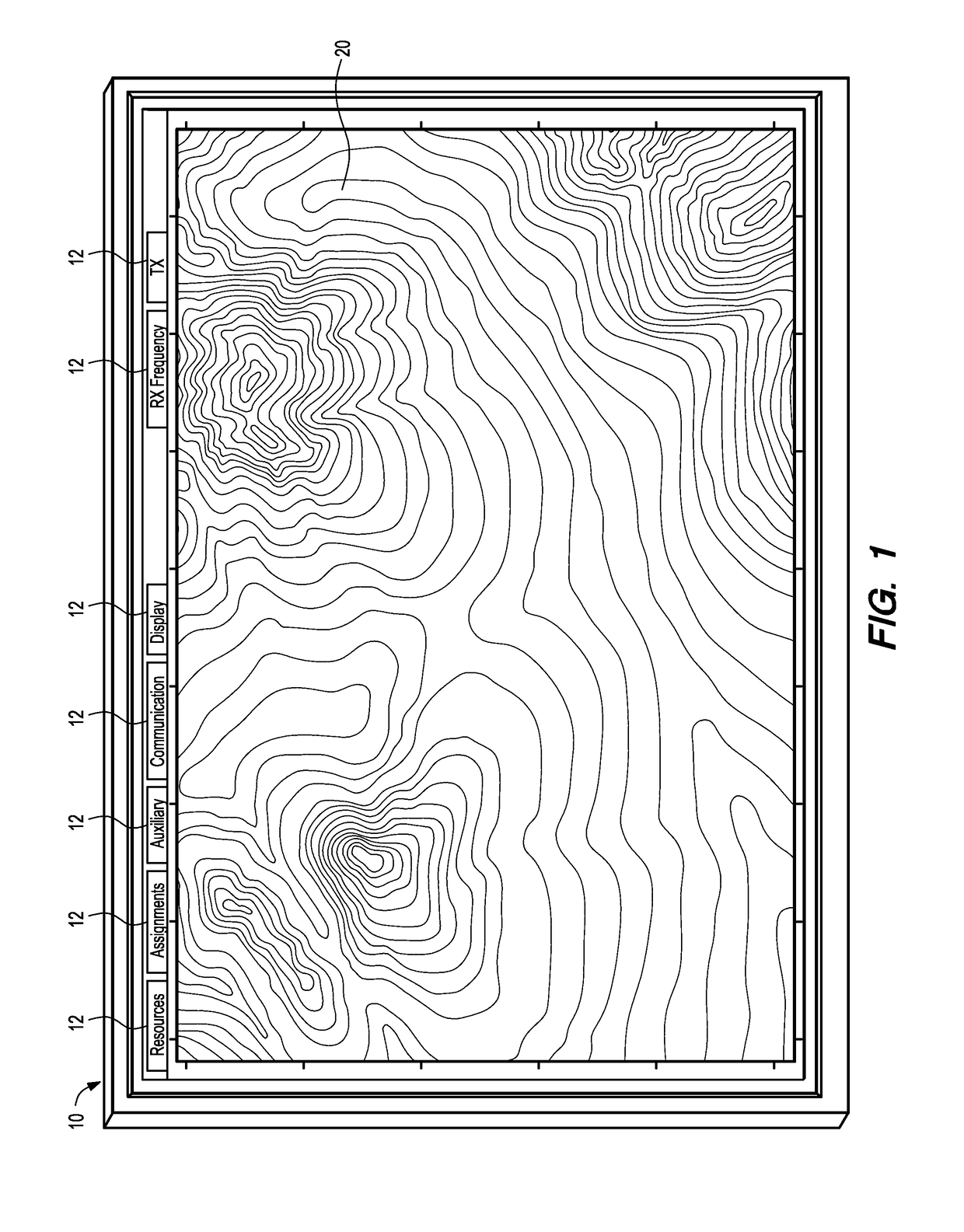
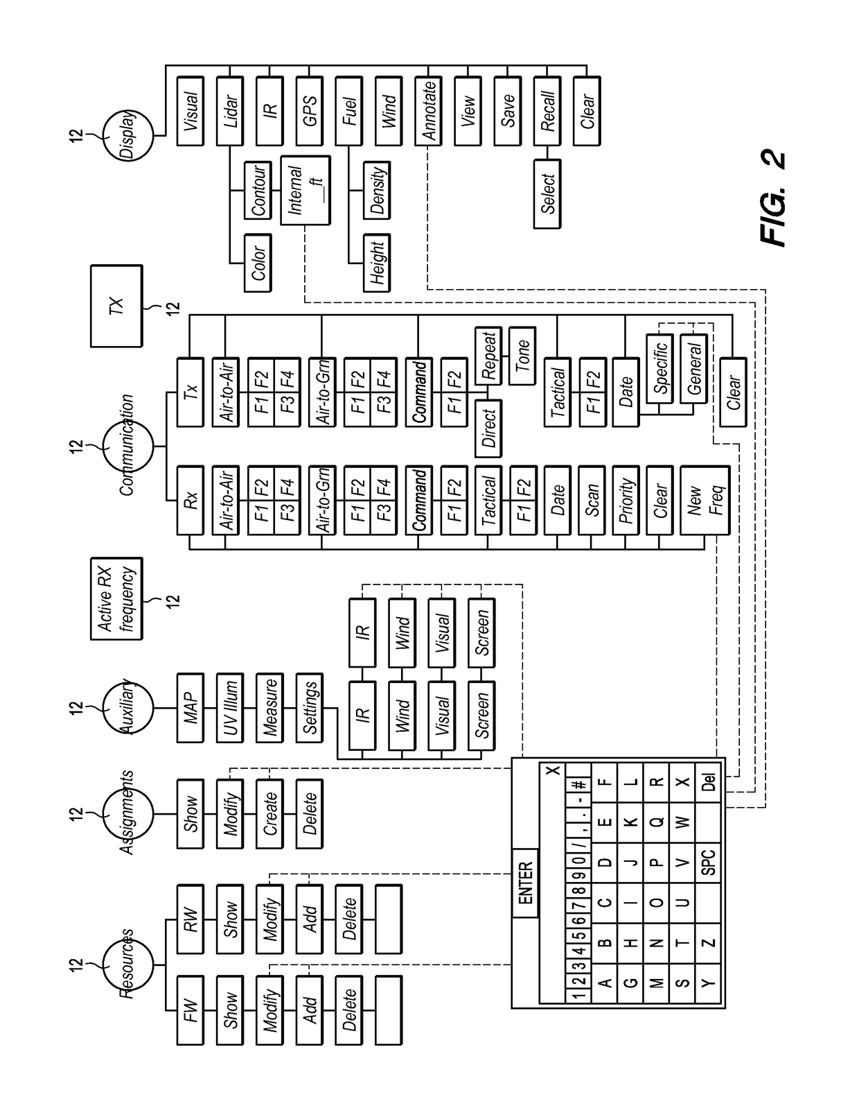
[0049]Referring to the drawings, wherein like reference numerals represent like parts throughout the various drawing figures, reference numeral 10 is directed to a display of digital elevation map DEM data and data pertinent to situational awareness for firefighting command personnel within a wildfire theatre. The display 10 is under the control of an operator to display more or less information as is available and useful to the operator in establishing situational awareness within the wildfire theatre and for deployment of firefighting resources. Various subsystems gather and condition data which is then fed to the display, at the instruction of the operator, to achieve presentation of the data considered most pertinent to the operator in combatting the wildfire.

[0050]The display 10 is generally a two-dimensional structure which would use one of a variety of display technologies including LED technology, LCD technology, CRT technology, or other two-dimensional display technology. T...


PUM


Abstract

A display provides optimized situational awareness to firefighting command personnel within a wildfire theatre. Lidar scanning data provides a digital elevation map of the wildfire theatre for the display. Geographic features such as lakes, roads, power lines and structures can be overlaid on the display. Lidar data utilizing multiple reflection signatures can be interpreted to represent fuel density and/or canopy height and such information can also be included upon the display. A burn area and active fire edge can be sensed by infrared scanner data and overlaid upon the display. The display can be utilized for input of firefighting command instructions, such as in the form of vectors or other annotations placed upon the display and correlated with airborne firefighting resources to be dropped at designated locations. Data provided to the display can be periodically updated to reflect the current situation. Firefighting resources are thus most effectively assigned.

Description

FIELD OF THE INVENTION[0001]The following invention relates to methods, tools and systems for providing situational awareness to command personnel engaged in wildfire fighting activities. More particularly, this invention relates to methods, tools and systems for gathering data within a wildfire theatre including terrain elevation data, terrain fuel density data, terrain canopy height data, terrain geographic feature data, wildfire location data including burn area and active front data and data on prior placements of firefighting agents and then presenting the data on a unified display which can also be optionally utilized for wildfire attack strategy and dispatching of firefighting resources, for maximum firefighting effectiveness.BACKGROUND OF THE INVENTION[0002]The destructiveness of wildfire to lives, property and the environment is often grave. Unlike some disasters which occur in an instant (e.g. earthquakes), leaving human resources best deployed merely to deal with the afte...

Claims


Application Information

Patent Timeline
IPC IPC(8): A62C3/02G01S17/08
CPCG01S17/08A62C3/0271A62C99/009G01S17/10G01S17/89G01S7/4802
Inventor DOTEN, LEONARD E.
Owner DOTEN LEONARD E
Why Eureka
Try Eureka