Real-time field mapping for autonomous agricultural platform

a technology of autonomous agriculture and real-time field mapping, applied in vehicle position/course/altitude control, process and machine control, instruments, etc., can solve problems such as unfavorable unmanned navigation, and the best current precision planting technology may not be sufficient to fully enable the operation of an unmanned agricultural robot on agricultural fields

Active Publication Date: 2017-08-10
ROWBOT SYST
View PDF0 Cites 12 Cited by
  • Summary
  • Abstract
  • Description
  • Claims
  • Application Information

AI Technical Summary

Benefits of technology

[0009]Embodiments of the present disclosure meet the need for a robust real-time mapping solution to support navigation of unmanned agricultural robots that carry out various in-season management tasks on agricultural fields. Examples of such management tasks include collecting plant and soil data, weed removal, fertilizer application, and seeding of cover crops between rows of a mature crop plants, like corn.

Problems solved by technology

Assuming that there is a high-quality as-planted map for a field, as well as onboard sensors for understanding the precise location of crop rows, there can still be unexpected situations that would impact the navigation of an unmanned agricultural robot, such as mis-planted rows or weeds.
Thus, even the best current precision planting technology may not be sufficient for fully enabling operation of the unmanned agricultural robot on agricultural fields.

Method used


Image

  • Real-time field mapping for autonomous agricultural platform
  • Real-time field mapping for autonomous agricultural platform
  • Real-time field mapping for autonomous agricultural platform

Examples


Embodiment Construction

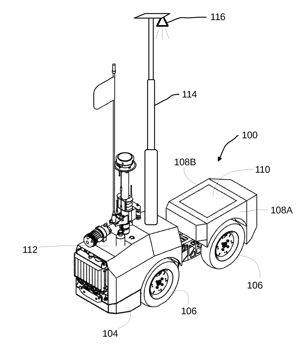
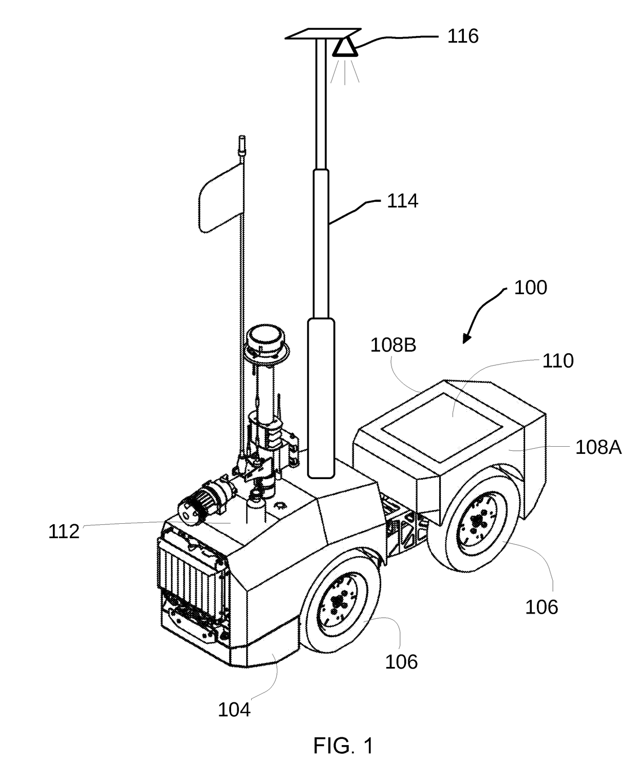
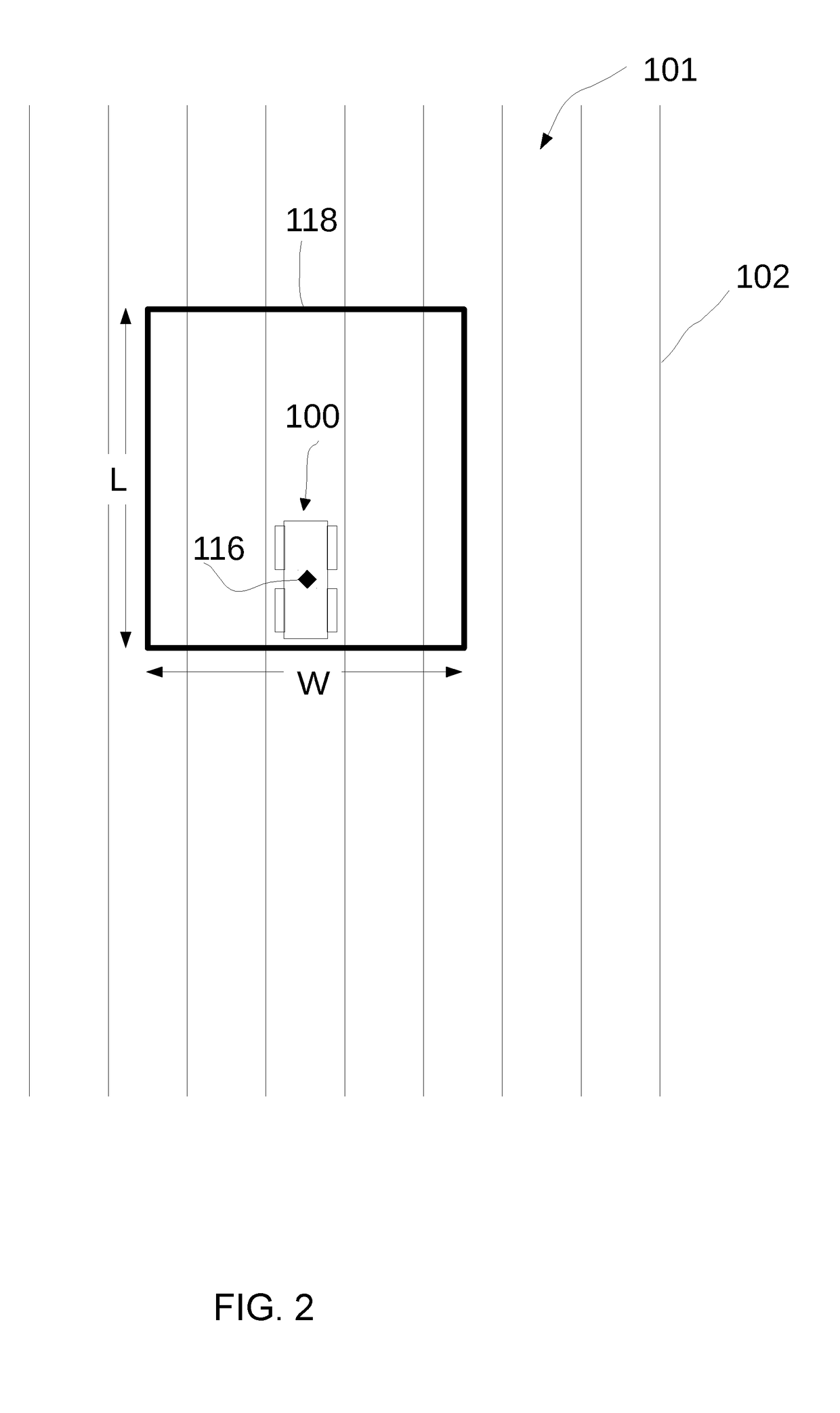
[0038]Referring to FIG. 1, an unmanned agricultural robot 100 is depicted according to an embodiment of the disclosure. Unmanned agricultural robot 100 can be configured to selectively perform one or more in season management tasks on an agricultural field 101 having adjacent rows of annual crop rows 102 planted so as to provide a conventional annual crop row spacing between two adjacent annual crop rows 102 of not more than thirty-six inches. Unmanned agricultural robot 100 can include a base 104 operably coupled to a plurality of ground engaging wheels 106. Unmanned agricultural robot 100 can have a first lateral side 108A and a second lateral side 108B, wherein the first and second lateral sides 108A / B oppose one another and are separated by a distance defining the width of the unmanned agricultural robot 100, the width so dimensioned as to be receivable within the space between two adjacent annual crop rows 102. Unmanned agricultural robot 100 can be programmed with a self-direc...


PUM


Abstract

A method of using an unmanned agricultural robot to generate an anticipatory geospatial data map of the positions of annual crop rows planted within a perimeter of an agricultural field, the method including the step of creating a geospatial data map of an agricultural field by plotting actual annual crop row positions in a portion of the geospatial data map that corresponds to a starting point observation window, and filling in a remainder of the geospatial data map with anticipated annual crop row positions corresponding to the annual crop rows outside of the starting point observation window, and refining the geospatial data map by replacing the anticipated annual crop row positions with measured actual annual crop row positions when an unexpected obstacle is encountered.

Description

RELATED APPLICATION INFORMATION[0001]This application claims the benefit of U.S. Provisional Application 62 / 293,070, filed Feb. 9, 2016, which is hereby incorporated by reference.TECHNICAL FIELD[0002]The present disclosure relates generally to unmanned agricultural robots. More particularly, the present disclosure relates to the generation of a geospatial data map through the use of a combination of measured, actual crop row positions and anticipated crop row positions.BACKGROUND[0003]Specific robotic solutions are currently being developed to aid farmers in the growth of annual row crops, such as corn. Specific solutions include improvements in tailoring the amount of fertilizer added to a particular area of an agricultural field to fit the needs of the crops within that area, fertilizing crops that have grown to a height where use of conventional fertilization equipment would be impractical, seeding a second cover crop while a first crop is still growing or mature and still on the...

Claims


Application Information

Patent Timeline
Patent Type & Authority Applications(United States)
IPC IPC(8): A01C21/00G05D1/02G05D1/00
CPCA01C21/005A01C21/007G05D2201/0201G05D1/021G05D1/0088A01B69/008G05D1/0274
Inventor CAVENDER-BARES, KENT
Owner ROWBOT SYST
Why Eureka
Try Eureka