Method for sensing interior spaces to auto-generate a navigational map

a technology for interior spaces and navigation, applied in the field of mapping, can solve the problems of difficult visual impairment, impracticality and relatively expensive, cumbersome and time-consuming process, etc., and achieve the effect of easy and fast deployment, less manual work, and convenient keeping up-to-da

Active Publication Date: 2017-09-14
INNERSPACE TECH INC
View PDF61 Cites 5 Cited by
  • Summary
  • Abstract
  • Description
  • Claims
  • Application Information

AI Technical Summary

Benefits of technology

[0048]Advantageously, the mapping procedure and routable map generation is dynamic and automated, resulting in substantially less manual work, which results in easier and faster deployment than current methods. The system is capable of detecting any changes made to any part of the floor plan, space, or device deployment, and such changes are registered for seamless, automatic updates of the floor plan and routable map, without any user intervention. The system is capable of real-time mapping, as the transponders can automatically respond to changes in their location due to renovations, temporary deployments of objects or structures, or relocations. For example, floor plans for dynamically configured interior spaces such as retail stores can be easily kept up-to-date.

Problems solved by technology

Some navigational tools are also able to provide turn-by-turn indoor navigation, however, such tools rely heavily on manual work to assemble the requisite map and directions, resulting in a cumbersome and time-consuming process.
Therefore, the user is forced to self-navigate around those barriers or structures based on an understanding of his / her relative position on that map, which can be challenging for visually impaired individuals.
Accordingly, in order to achieve the positioning accuracy required for turn-by-turn navigation within typical buildings, the deployment would necessitate a relatively high density of beacons / tags, which would be impractical and relatively expensive.
In addition, proximity-based technologies are fundamentally unaware of the surrounding space, that is, walls, passageways or openings of a building, or other objects or obstacles.
Therefore, most areas of a building would lack sufficient coverage to support navigation, and additional deployment of routers would be required to enable navigation.
Furthermore, unpredictable signal reflection and attenuation inside buildings introduces distance measurement errors, thereby severely impacting the accuracy of the positioning information, thus rendering turn-by-navigation directions non-reliable.
Additionally, most companies or organizations are reluctant to increase network traffic and latency on their Wi-Fi networks, or allow access to Wi-Fi networks carrying sensitive data.
Site walks involve considerable manual effort, requiring a user (or paid consultant) to physically walk the entire indoor space while holding a purpose-built device (or smartphone and app) in order to define every walkable space in the building, such as each room and hallway, as well as in aisles in larger, open spaces.
As such, this process can be time consuming and error prone.
However, this process involves significant post processing human involvement for purposes of correction and adjustment.

Method used


Image

  • Method for sensing interior spaces to auto-generate a navigational map
  • Method for sensing interior spaces to auto-generate a navigational map
  • Method for sensing interior spaces to auto-generate a navigational map

Examples


Embodiment Construction

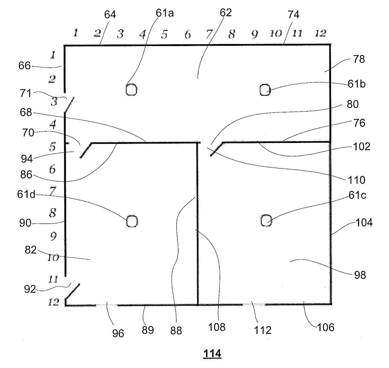
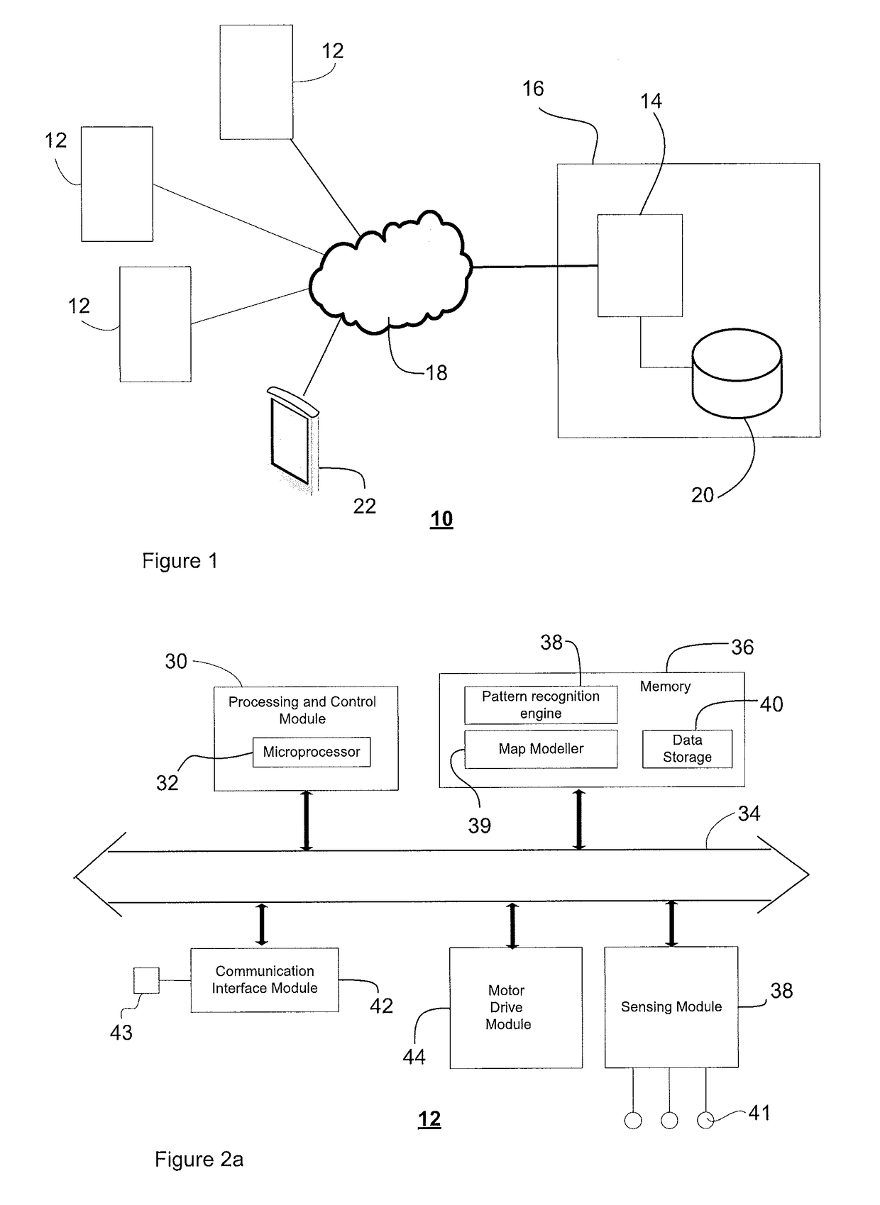
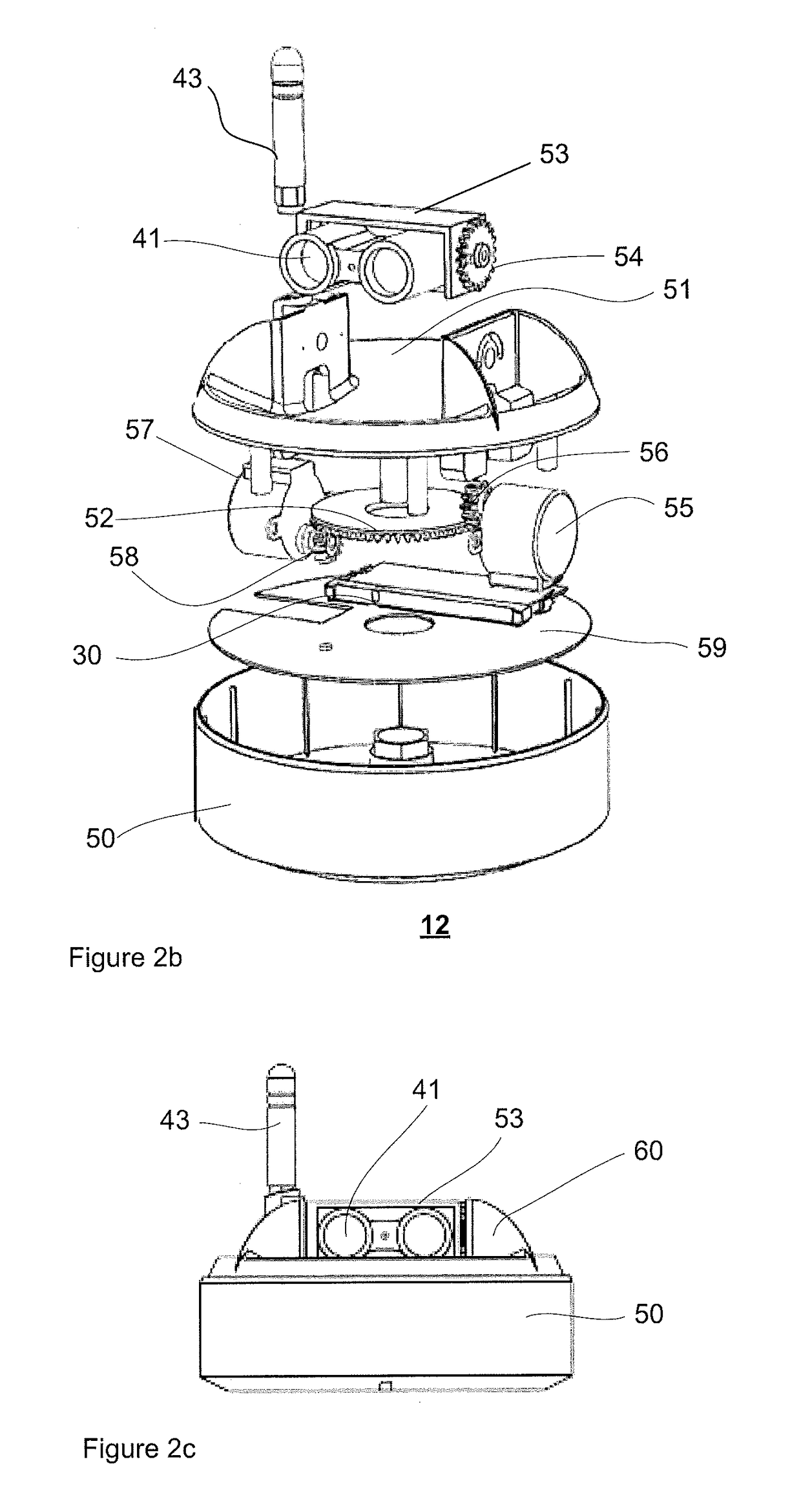
[0069]The detailed description of exemplary embodiments of the invention herein makes reference to the accompanying block diagrams and schematic diagrams, which show the exemplary embodiment by way of illustration and its best mode. While these exemplary embodiments are described in sufficient detail to enable those skilled in the art to practice the invention, it should be understood that other embodiments may be realized and that logical and mechanical changes may be made without departing from the spirit and scope of the invention. Thus, the detailed description herein is presented for purposes of illustration only and not of limitation. For example, the steps recited in any of the method or process descriptions may be executed in any order and are not limited to the order presented.

[0070]Moreover, it should be appreciated that the particular implementations shown and described herein are illustrative of the invention and its best mode and are not intended to otherwise limit the ...


PUM


Abstract

A method for generating a routable map of a spatial environment, the method comprising the steps of: positioning a transponder in a location within said spatial environment at least one sensor; associating at least one sensor with said transponder, said at least one sensor being rotatable in at least one plane; measuring distances within said spatial environment with said at least one sensor relative to said location; and composing a local map model of spatial environment based on said measurements.

Description

CROSS-REFERENCE TO RELATED APPLICATIONS[0001]This application is a continuation of International Patent Application No. PCT / CA2015 / 051343, filed on Dec. 17, 2015, which claims the benefit of priority to U.S. Provisional Application Ser. No. 62 / 093,837, filed on Dec. 28, 2014.FIELD OF THE INVENTION[0002]The present invention relates to mapping, more particularly it relates to methods and systems for sensing an interior space to automatically generate a map to facilitate navigation thereof.DESCRIPTION OF THE RELATED ART[0003]Mapping of interior spaces is gaining in popularity as there is a need to easily navigate large buildings, such as hospitals, government buildings, malls, convention centers, libraries, universities, stadiums, airports, and so forth. Navigational maps are often created manually using floor plan images, and these maps are used with portable devices to provide navigational tools which determine the user's position within a given space.[0004]Some navigational tools a...

Claims


Application Information

Patent Timeline
Patent Type & Authority Applications(United States)
IPC IPC(8): G01S7/00G06F17/30G06T17/05G01S17/89
CPCG01S7/003G01S17/89G06F17/30241G01S5/14G01C21/206G01C21/34G06T17/05G06F16/29G01C23/00
Inventor WU, JAMESGAMBLEN, JASONMACGILLIVRAY, MATT
Owner INNERSPACE TECH INC
Why Eureka
Try Eureka