On-board backup and Anti-spoofing GPS system

a technology of gps and backup, applied in the field of global position system (“ gps”) navigation, can solve the problems of unintentional interference, natural occurrence, and inability to always have gps signals available,

Active Publication Date: 2017-12-14
THE BOEING CO
View PDF6 Cites 47 Cited by
  • Summary
  • Abstract
  • Description
  • Claims
  • Application Information

AI Technical Summary

Problems solved by technology

Unfortunately, a problem with having a high dependence on GPS technologies is that GPS signals are not always be available (or may be interrupted) and at this time there is no backup systems to GPS other than manual navigation methods utilizing environmental sensors such as, for example, radar and celestial navigation.
Examples of why GPS signals may not be available include intentional interference, unintentional interference, natural occurrences, and lack of coverage.
Lack of coverage includes situations where the environment does not allow a GPS receiver to have a clear view of the nece

Method used


Image

  • On-board backup and Anti-spoofing GPS system
  • On-board backup and Anti-spoofing GPS system
  • On-board backup and Anti-spoofing GPS system

Examples


Embodiment Construction

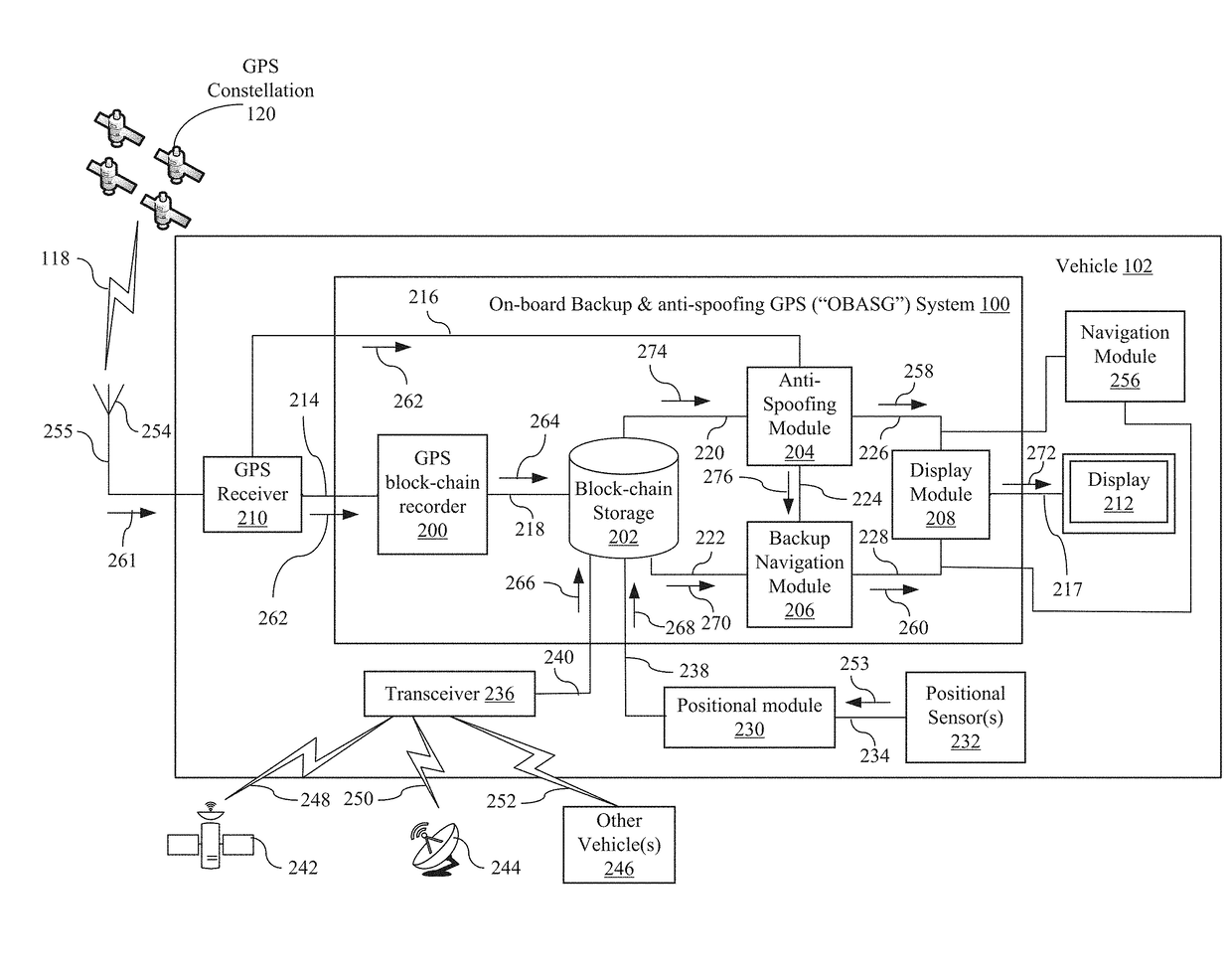
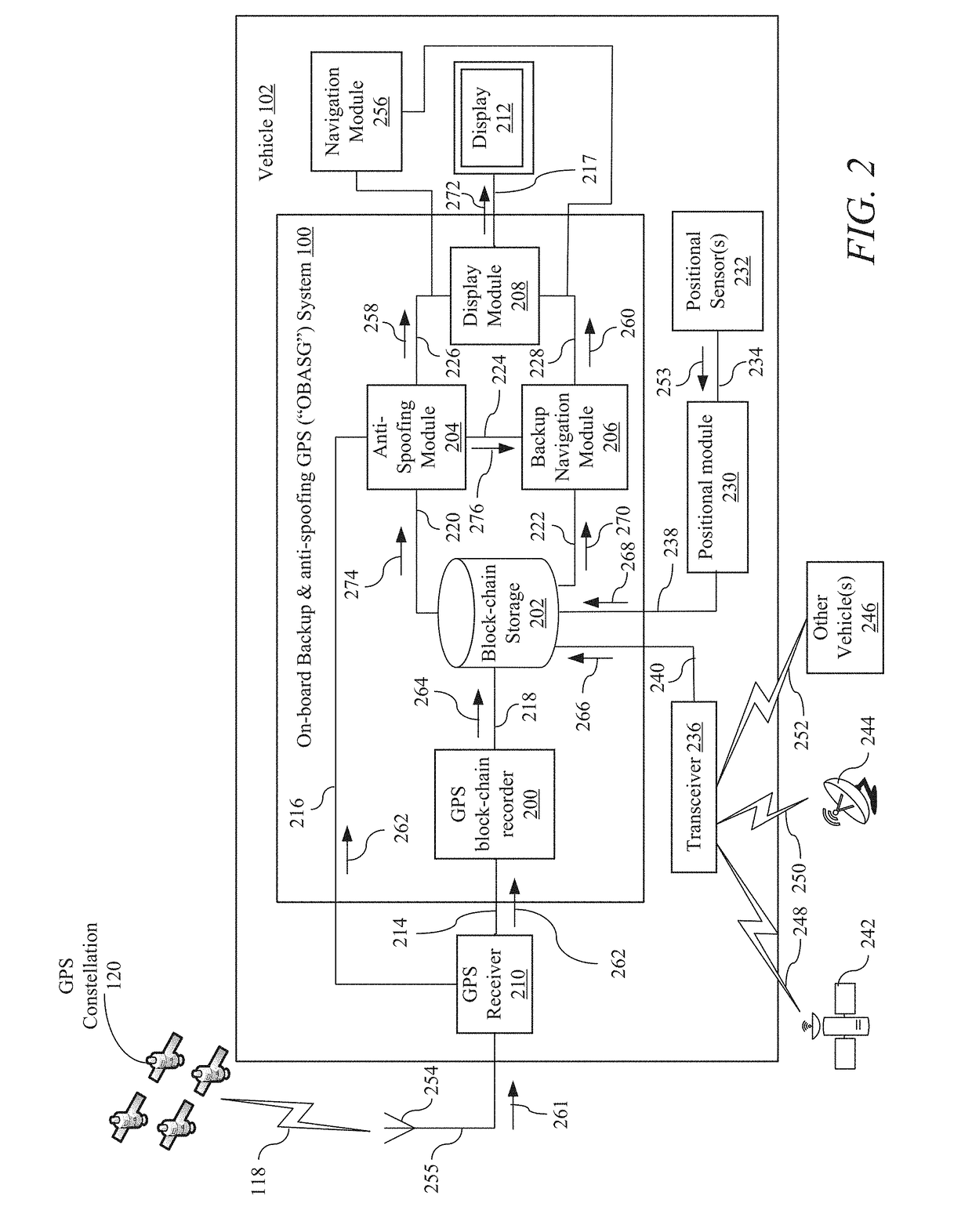
[0017]Disclosed is an on-board backup and anti-spoofing GPS (“OBASG”) system for navigating a vehicle through an environment with a GPS receiver. The GPS receiver is configured to receive GPS signals within the environment where the GPS signals may suffer a GPS outage or are unreliable within the environment. In general, the OBASG includes a GPS block-chain recorder, a block-chain storage module, an anti-spoofing module, and a backup navigation module. The GPS block-chain recorder is in signal communication with the GPS receiver and the block-chain storage module. The block-chain storage module is also in signal communication with the anti-spoofing module and the backup navigation module. The anti-spoofing module is also in signal communication with both the GPS receiver and the backup navigation module.

[0018]In an example of operation, the OBASG performs a method for navigating the vehicle through the environment with the GPS receiver, where the GPS receiver is configured to receiv...


PUM


Abstract

Disclosed is an on-board backup and anti-spoofing GPS (“OBASG”) system for navigating a vehicle through an environment with a GPS receiver. The GPS receiver is configured to receive GPS signals within the environment where the GPS signals may suffer a GPS outage or are unreliable within the environment. In general, the OBASG includes a GPS block-chain recorder, a block-chain storage module, an anti-spoofing module, and a backup navigation module.

Description

BACKGROUND1. Field[0001]The present disclosure relates to Global Position System (“GPS”) navigation, and more, particularly to navigation through unreliable GPS environments.2. Related Art[0002]At present, the United States (“U.S.”) Government is moving forward initiatives that are creating an ever increasing dependency on the utilization of Global Position System (“GPS”) for navigation in military operations, government intelligence gathering activities, commercial airspace management, railway collision avoidance, maritime operations, and consumer navigation.[0003]Existing GPS navigation systems include NAVSTAR (an acronym derived from either “Navigation Signal Timing and Ranging” or “Navigation Satellite Timing and Ranging”) developed and operated by the United States Air Force and the Global Navigation Satellite System (“GLONASS”) developed by the Soviet Union and presently operated by the Russia Aerospace Defense Forces. Future GPS navigation systems will include global navigati...

Claims


Application Information

Patent Timeline
IPC IPC(8): G01S19/21G01S19/35
CPCG01S19/35G01S19/215G01S19/48G01S19/03H04L9/3236H04L9/50
Inventor RAAB, CHRISTOPHER W.GLATFELTER, JOHN W.HILL, KELLY C.
Owner THE BOEING CO
Why Eureka
Try Eureka