Aerial traffic monitoring radar

Active Publication Date: 2018-01-25
ARTSYS360 LTD
View PDF7 Cites 13 Cited by
  • Summary
  • Abstract
  • Description
  • Claims
  • Application Information

AI Technical Summary

Benefits of technology

The patent describes a small radar system that is easy to install and complies with urban safety regulations. It is designed to be rapidly deployed and has low radiated power. The technical effects of this invention include its small size, low power, and easy installation.

Problems solved by technology

In high-density urban environments, as well as in smaller cities and rural areas, demand on ground transportation infrastructure has increased and continues to increase to the point that many metropolitan areas are heavily congested and road transportation networks are inefficient.
The inefficiencies are also dramatic in cities in many emerging countries or other locations where ground infrastructure has not scaled quickly enough to follow the population increase or the growth in the economy.
Hence, often enough, access to physical goods is hindered by the inflexible, inefficient (in energy, time and cost) transportation solutions of the present day.
One of the major technical problems that may, at least partially, hinder advancing the legal operation of UAVs is the current lack of an efficient way to monitor their aerial traffic, namely, the ability to detect, track, and spatially locate one or more flying UAVs, at real time.
A further technical problem concerning the operation of UAVs is controlling the flying routes of UAVs, while taking into consideration, at every given moment, the spatial location of other objects flying in the UAV's immediate vicinity or objects projecting from the ground so as in times of emergency, immediate notification and instructions may be provided to one or several UAVs simultaneously in order to control UAV traffic to avoid these obstacles.

Method used


Image

  • Aerial traffic monitoring radar
  • Aerial traffic monitoring radar
  • Aerial traffic monitoring radar

Examples


Embodiment Construction

[0076]In the following detailed description of various embodiments, reference is made to the accompanying drawings that form a part thereof, and in which are shown by way of illustration specific embodiments in which the invention may be practiced. It is understood that other embodiments may be utilized and structural changes may be made without limiting the scope of the present invention.

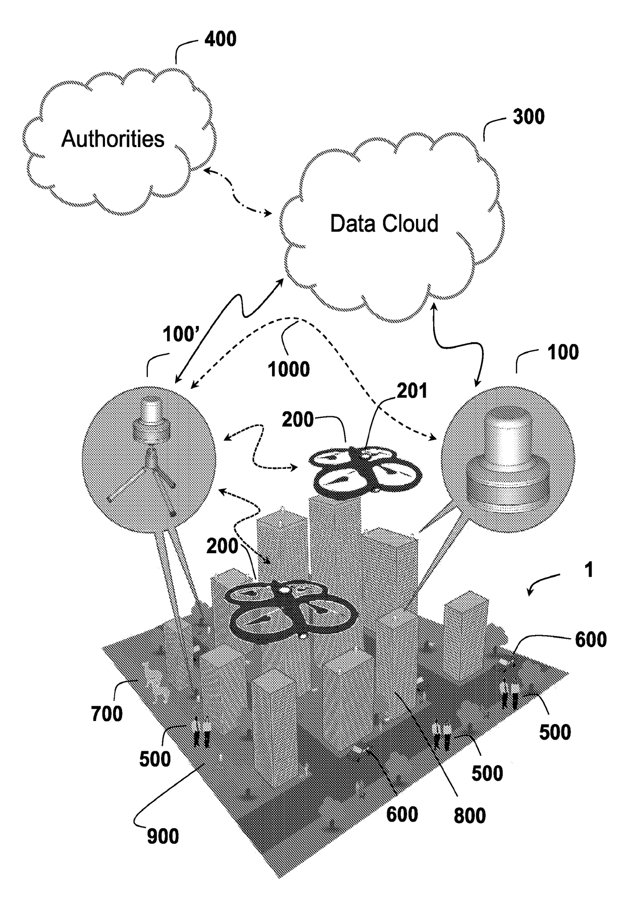
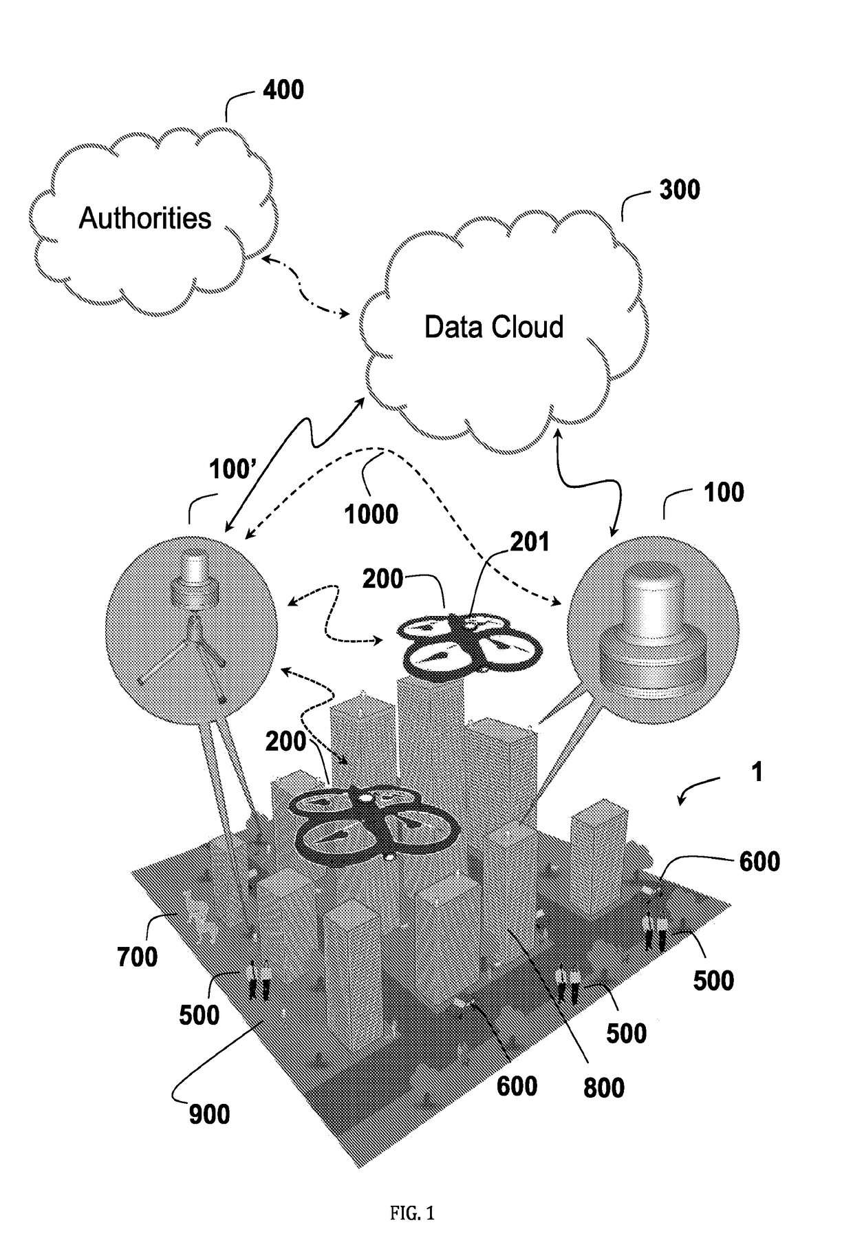
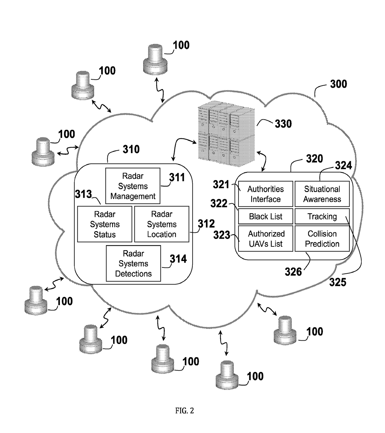
[0077]A 3D radar system for aerial traffic monitoring of unmanned aerial vehicles (UAVs), which addresses the technical problems of: (i) lack of an efficient mean for monitoring UAVs aerial traffic, namely, the ability to detect, track, and spatially locate one or more flying UAVs, at real time, and (ii) controlling the flying routes of UAVs, while taking into consideration, at every given moment, the spatial location of other objects flying in the UAV's immediate vicinity or objects erecting from the ground so as in times of emergency, immediate notification and instructions may be provided to one...


PUM


Abstract

An unmanned aerial vehicles (UAVs) aerial traffic monitoring system is provided and includes one or more UAVs comprising a transponder and at least one of a transmitter, a localization module and / or a communication module, radar systems covering and locating objects from 0° to 360° in azimuth and within a range of from −45° to 45° in elevations below and above the horizon, a cloud software stored in a non-transitory memory and configured to be executed by a processor, that stores records of operating UAVs so as to allow online and real time situational awareness of UAV aerial traffic, aerial traffic load, and aerial collision predictions.

Description

RELATED APPLICATIONS[0001]The present application is related to U.S. Application No. PCT / US16 / 16507, filed on Feb. 4, 2016, the entirety of which is incorporated by reference herein.FIELD AND BACKGROUND OF THE INVENTION[0002]The present invention, in some embodiments thereof, relates to radar systems and more particularly to systems and methods for detecting, tracking and monitoring the spatial location of unmanned aerial vehicles (UAVs).[0003]An unmanned aerial vehicle or unmanned aircraft vehicle (UAV), sometimes also referred to as an unpiloted air system (UAS), an unpiloted aerial vehicle (UAV) or a remotely piloted aircraft (RPA), is an aircraft without a human pilot aboard. According to U.S. International Civil Aviation Organization (ICAO), UAVs are classified into two types: (i) autonomous aircraft; and (ii) remotely piloted aircraft system (PRAS), which is subject to civil regulation under ICAO and under the relevant national aviation authority. The typical launch and recove...

Claims


Application Information

Patent Timeline
IPC IPC(8): G01S13/91G01S13/86G01S13/87G08G5/04G01S3/46G01S5/00G01S7/00G08G5/00G01S13/93G01S19/49G01S13/933
CPCG01S13/91G01S13/9303G01S13/86G01S13/87G01S19/49G01S3/46G01S5/0027G01S7/003G08G5/0078G08G5/0069G08G5/045G08G5/0026G08G5/006G08G5/0082G01S13/933
Inventor ZOREA, MEIRBEN-ARI, EREZ
Owner ARTSYS360 LTD
Why Eureka
Try Eureka