
Occupancy Map Updates Based on Sensor Data Collected by Autonomous Vehicles

a technology of autonomous vehicles and occupancy maps, applied in scene recognition, navigation instruments, instruments, etc., can solve the problems of difficult automatic driving, inability to observe everything all the time, and inability of vehicle sensors to observe certain things early, so as to improve passenger and pedestrian safety and improve the accuracy of occupancy maps

Active Publication Date: 2018-07-05
NVIDIA CORP
View PDF8 Cites 108 Cited by
  • Summary
  • Abstract
  • Description
  • Claims
  • Application Information

AI Technical Summary

Benefits of technology

This patent describes an online system that uses data from autonomous vehicles to create a high definition map of a geographic region. The autonomous vehicles detect map discrepancies and send those details to the online system. The system then updates occupancy maps to improve accuracy and passenger and pedestrian safety. The system uses sensor data to obtain a continuous update of the environment as moving entities move around and changes occur. This helps to ensure that the map is always accurate and can be used for navigation purposes.

Problems solved by technology

Automation of driving is difficult due to several reasons.
For example, autonomous vehicles use sensors to make driving decisions on the fly, but vehicle sensors cannot observe everything all the time.
Vehicles sensors may not observe certain things early enough to make decisions.
In addition, lanes and signs may be missing on the road or knocked over or hidden by bushes, and therefore not detectable by sensors.
Furthermore, road signs for rights of way may not be readily visible for determining from where vehicles could be coming, or for swerving or moving out of a lane in an emergency or when there is a stopped obstacle that must be passed.
However conventional maps have several drawbacks that make them difficult to use for an autonomous vehicle.
For example maps do not provide the level of accuracy required for safe navigation (e.g., 10 cm or less).
GPS systems provide accuracies of approximately 3-5 meters, but have large error conditions resulting in an accuracy of over 100 m. This makes it challenging to accurately determine the location of the vehicle.
This process is expensive and time consuming (e.g., taking possibly months to complete a map).
Therefore, maps assembled using such techniques do not have fresh data.
But survey cars are expensive and limited in number, so cannot capture most of these updates.
As a result, conventional techniques of maintaining maps are unable to provide the right data that is sufficiently accurate and up-to-date for safe navigation of autonomous vehicles.

Method used


Image

  • Occupancy Map Updates Based on Sensor Data Collected by Autonomous Vehicles
  • Occupancy Map Updates Based on Sensor Data Collected by Autonomous Vehicles
  • Occupancy Map Updates Based on Sensor Data Collected by Autonomous Vehicles

Examples


Embodiment Construction

Overview

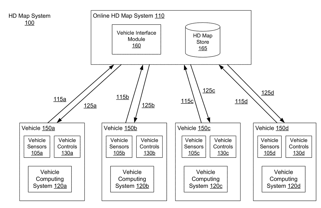
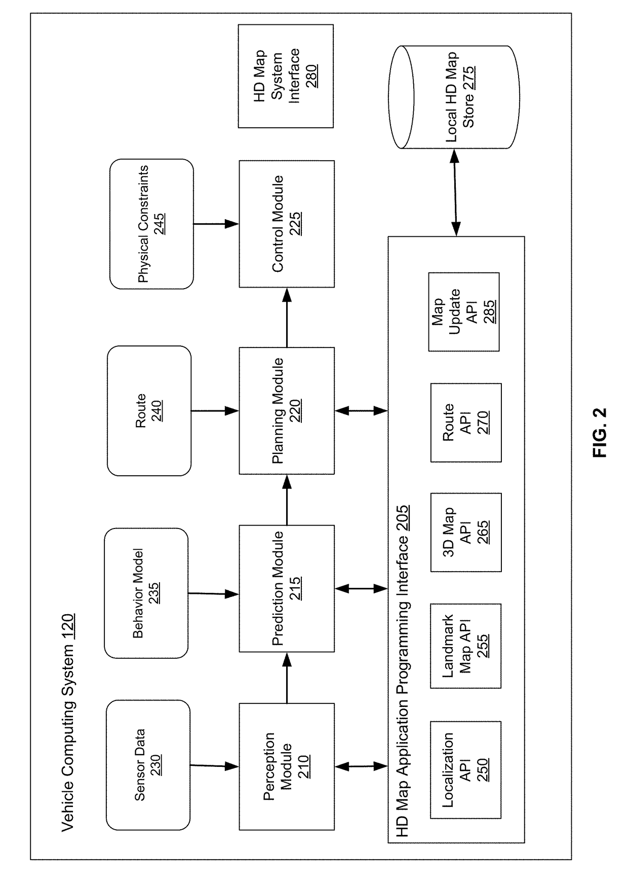
[0028]Embodiments of the invention maintain high definition (HD) maps containing up to date information using high precision. The HD maps may be used by autonomous vehicles to safely navigate to their destinations without human input or with limited human input. An autonomous vehicle is a vehicle capable of sensing its environment and navigating without human input. Autonomous vehicles may also be referred to herein as “driverless car,”“self-driving car,” or “robotic car.” An HD map refers to a map storing data with very high precision, typically 5-10 cm. Embodiments generate HD maps containing spatial geometric information about the roads on which an autonomous vehicle can travel. Accordingly, the generated HD maps include the information necessary for an autonomous vehicle navigating safely without human intervention. Instead of collecting data for the HD maps using an expensive and time consuming mapping fleet process including vehicles outfitted with high resolution sens...


PUM


Abstract

An online system builds a high definition (HD) map for a geographical region based on sensor data captured by a plurality of autonomous vehicles driving through a geographical region. The autonomous vehicles detect map discrepancies based on differences in the surroundings observed using sensor data compared to the high definition map and send messages describing these map discrepancies to the online system. The online system updates existing occupancy maps to improve the accuracy of the occupancy maps (OMaps), and to thereby improve passenger and pedestrian safety. While vehicles are in motion, they can continuously collect data about their surroundings. When new data is available from the various vehicles within a fleet, this can be updated in a local representation of the occupancy map and can be passed to the online HD map system (e.g., in the cloud) for updating the master occupancy map shared by all of the vehicles.

Description

CROSS-REFERENCE TO RELATED APPLICATION[0001]This application claims the benefit of U.S. Provisional Application No. 62 / 441,069, filed Dec. 30, 2016, which is hereby incorporated by reference in its entirety.BACKGROUND[0002]This disclosure relates generally to maps for autonomous vehicles, and more particularly to updating high definition maps based on sensor data collected by to autonomous vehicles.[0003]Autonomous vehicles, also known as self-driving cars, driverless cars, auto, or robotic cars, drive from a source location to a destination location without requiring a human driver to control and navigate the vehicle. Automation of driving is difficult due to several reasons. For example, autonomous vehicles use sensors to make driving decisions on the fly, but vehicle sensors cannot observe everything all the time. Vehicle sensors can be obscured by corners, rolling hills, and other vehicles. Vehicles sensors may not observe certain things early enough to make decisions. In additi...

Claims


Application Information

Patent Timeline
IPC IPC(8): G01C21/30G01C21/36G06K9/00G06F17/30B60W40/02B60W30/095G05D1/00G05D1/02G06V10/75G06V10/764G06V10/98H04L69/40
CPCG01C21/30G01C21/3635G06K9/00791G06F17/30241B60W40/02B60W30/0956G05D1/0088G05D1/0214B60W2550/10B60W2550/402G05D1/0274H04L67/10H04L69/40G06F16/29H04L67/12G08G1/096827G01C21/3822Y04S40/18G01C21/3811G06V20/64G06V20/58G06V20/56G06V10/98H04L67/53H04L67/52G06V10/75G06V10/764G06F18/22G01C21/3848G01C21/3841G01C21/3867G06V20/582G06V20/584B60W2554/00B60W2556/50G06F18/24G06T17/05
Inventor WHEELER, MARK DAMONWU, XIAQING
Owner NVIDIA CORP
Features
  • Generate Ideas
  • Intellectual Property
  • Life Sciences
  • Materials
  • Tech Scout
  • Unparalleled Data Quality
  • Higher Quality Content
  • 60% Fewer Hallucinations
Learn More