Simplification of Data for Representing an Environment, Based on the Heights and Elevations of Polyhedrons that Define Structures Represented in the Data

a technology of environment data and polyhedrons, applied in the field of representation of an environment, can solve the problems of large computer-processing resources and computational intensive operations that are performed on data, and achieve the effects of reducing the number of polyhedrons that need to be considered while using environment data, reducing computation costs, and improving data processing system functioning

Active Publication Date: 2019-02-07
POLARIS WIRELESS
View PDF0 Cites 0 Cited by
  • Summary
  • Abstract
  • Description
  • Claims
  • Application Information

AI Technical Summary

Benefits of technology

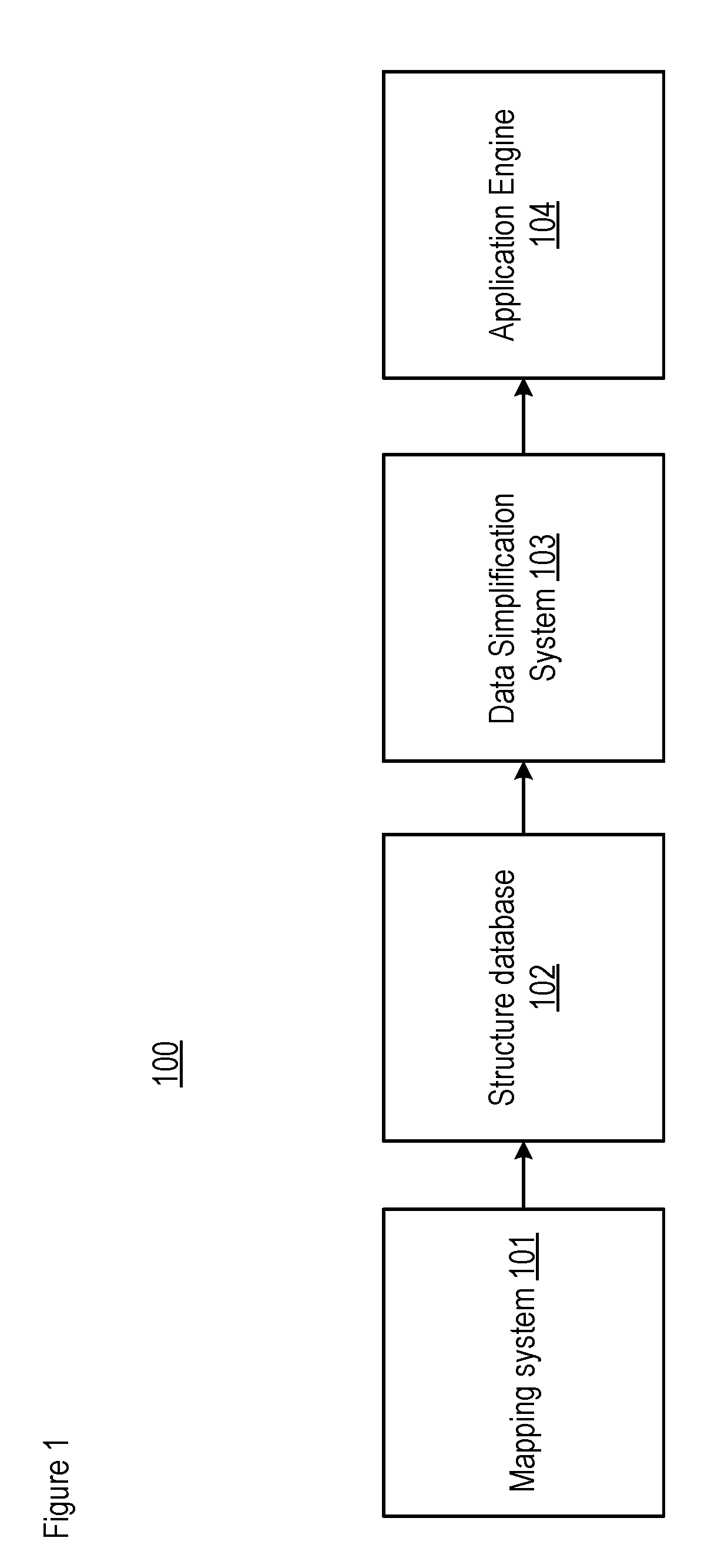
[0010]The present invention enables an improvement in the functioning of a data-processing system that uses environment data, in applications such as but not limited to modeling, visualization, and navigation, and without at least some of the disadvantages in the prior art. In particular, embodiments of the present invention account for the different heights and elevations of polyhedrons in the structure data. At a given level of elevation, embodiments of the present invention form a consolidated polygon footprint to define a consolidated polyhedron, from two or more constituent polygon footprints defining constituent polyhedrons in the structure data. The embodiments of the present invention repeat this process at subsequent levels of elevation. In doing so, the number of polyhedrons that need to be considered while using the environment data is reduced. As a result, fewer computations are required by applications that use the simplified environment data, and, by association, fewer resources are utilized by a computer executing such applications. Furthermore, such an improvement in the functioning of the computer, or other data-processing system, is achieved without sacrificing the quality of the subsequent application of the environment data. As an added benefit, the simplification techniques disclosed herein can be performed offline and, depending on how the environment data is to be used, need be performed only once.
[0011]The inventors had an insight, which when applied to a use of the environment data achieves the aforementioned improvement without a sacrifice in quality, as explained here. It is already known that in the field of modeling electromagnetic waves propagating through a region occupied by buildings, the techniques of modeling the particular environment utilize building data having a known error. For example, such building data can be based upon satellite data, which is specified as being accurate to within a particular resolution of detail (e.g., 2 meters, 5 meters, 20 meters, 30 meters, etc.). In accordance with the illustrative embodiment of the present invention, and based on the inventors' insight, the techniques disclosed herein account for the resolution of the building data. In particular, for each level of elevation being processed, a polyhedron at that level can be either retained or removed based on its height in relation to the resolution of the building data. For example, the coarser the data resolution, the taller the polyhedron that can be removed. Then, the retained polyhedrons at that level of elevation are combined, thereby consolidating the number of polyhedrons.
[0012]In forming new polyhedrons from individual polyhedrons in this way, the disclosed techniques are able to achieve a reduction in the number of polyhedrons that must be processed, thereby improving the functioning of the computer. And, as the inventors realized, by limiting the maximum height of a polyhedron that can be removed based on the resolution of the data, the disclosed technique accomplishes the reduction in the number of polyhedrons without increasing the error of the representation of an environment beyond that which was already present in the building data, thereby maintaining the quality of the particular use of the building data. Furthermore, the improvement that is achieved applies not only to an improvement in the dataset itself, but also applies to the technology that is used in support of various applications such as, while not being limited to, i) electromagnetic wave propagation modeling, ii) gaming, and iii) navigation (e.g., of drones, of self-drive vehicles, of vehicles in general, of other things used for transportation, etc.).
[0013]In some embodiments of the present invention, the technique for reducing the number of polyhedrons based on elevation and height that is disclosed herein can be used in conjunction with reducing the number of vertices that are required to represent one or more structures in the dataset, thereby reducing further the total number of walls, the number of intersection checks that need to be performed, and the computations that are required of the data-processing system. The technique for reducing the number of polyhedrons can also consider how the polyhedrons overlap horizontally.

Problems solved by technology

The operations that are performed on the data are often computationally intensive, however, and can require large amounts of computer-processing resources, such as instruction cycles, memory, and input-output operations.

Method used


Image

  • Simplification of Data for Representing an Environment, Based on the Heights and Elevations of Polyhedrons that Define Structures Represented in the Data
  • Simplification of Data for Representing an Environment, Based on the Heights and Elevations of Polyhedrons that Define Structures Represented in the Data
  • Simplification of Data for Representing an Environment, Based on the Heights and Elevations of Polyhedrons that Define Structures Represented in the Data

Examples


Embodiment Construction

[0042]Based on—For the purposes of this specification, the phrase “based on” is defined as “being dependent on” in contrast to “being independent of”. The value of Y is dependent on the value of X when the value of Y is different for two or more values of X. The value of Y is independent of the value of X when the value of Y is the same for all values of X. Being “based on” includes both functions and relations.

[0043]Dataset—For the purposes of this specification, the phrase “dataset” is defined as a collection of data, A dataset can originate from an organized collection of data, such as a database.

[0044]Edge—For the purposes of this specification, the phrase “edge” is defined as a line segment joining two vertices in a polygon or polyhedron.

[0045]Elevation—For the purposes of this specification, the phrase “elevation” is defined as height above a given level (e.g., ground, MSL, etc.). A “start elevation” is defined as the height of the lowest point on a polyhedron, while an “end e...


PUM


Abstract

A technique for simplifying structure data for representing an environment. Polyhedrons can make up structure data used in an application such as modeling, visualization, and navigation. Consequently, the operations that are performed on the data often involve determining, for each polyhedron that defines a structure such as a building, whether the polyhedron obstructs a line-of-sight line between a first point in space being considered in the application and a second point. In order to determine whether a polyhedron obstructs a line-of-sight line, a data-processing system operating on the structure data must determine whether any walls of the polyhedron intersect the line. Thus, the more polyhedrons there are or the more vertices that are in each polyhedron, the more walls there are, and the more intersection checks are required, thereby adding to the computations. The disclosed technique reduces the number of walls by simplifying objects that make up the structure data.

Description

CROSS REFERENCE TO RELATED APPLICATIONS[0001]This application is related to “Simplification of data for representing an environment, via the expansion of polyhedrons that define structures represented in the data,” U.S. application Ser. No. ______ , Attorney Docket 465-392us1, and “Simplification of data for representing an environment, via the reduction of vertices that define structures represented in the data,” U.S. application Ser. No. ______ , Attorney Docket 465-398us1, both filed on the same day as the present application and incorporated by reference herein.FIELD OF THE INVENTION[0002]The present invention relates to representation of an environment in general, and, more particularly, to the simplification of data for representing an environment, based on the heights and elevations of polyhedrons that define structures that are represented in the data.BACKGROUND OF THE INVENTION[0003]Various applications use data that represent a particular environment. One example of such a...

Claims


Application Information

Patent Timeline
Patent Type & Authority Applications(United States)
IPC IPC(8): G06F17/50
CPCG06F2217/02G06F17/50H04B17/391G06F30/13G06F30/367F21V13/10G06F30/00G06F2111/20
Inventor DEGLI-ESPOSTI, VITTORIOLU, JONATHANVITUCCI, ENRICO MARIA
Owner POLARIS WIRELESS
Why Eureka
Try Eureka