Systems and methods for improved atmospheric monitoring and GPS positioning utilizing GNSS tomographic refractivity

Active Publication Date: 2019-05-16
SPIRE GLOBAL
View PDF1 Cites 15 Cited by
  • Summary
  • Abstract
  • Description
  • Claims
  • Application Information

AI Technical Summary

Benefits of technology

[0006]Certain implementations of the disclosed technology may include a method of receiving, at a processing system, and from a plurality of Global Navigation Satellite Systems (GNSS) stations, navigation data corresponding to computed positions of the plurality of GNSS stations. The method can include receiving, at the processing system, GNSS transmitter information including one or more of: GNSS satellite positional information; GNSS clock information; and GNSS transmission frequency information. The method can further include: determining, based at least in part on the received navigation data and the received GNSS transmitter information, ionosphere and atmosphere refractivity associated with navigation data; determining, based at least in part on the refractivity, three-dimensional (3D) density states of the atmosphere and ionosphere corresponding to intersections of two or more GNSS signals; calculating, by the processing system, and based on the determined 3D density states, data fields of a model representing the three-3D density states; and transmitting position adjustment data to calibrate a navigation position of at least one of the plurality of the GNSS stations based at least in part on the calculated data fields of the model.
[0007]According to another example implementation, a satellite constellation communications system is provided, which may include a central command and control system configured for communication with at least one satellite associated with a constellation, and by at least one ground station. The s

Problems solved by technology

Such refraction can create errors in positional accuracy of GPS trilateration.
In addition, the error introduced by the ionosphere can be relatively large when the satellite is ne

Method used


Image

  • Systems and methods for improved atmospheric monitoring and GPS positioning utilizing GNSS tomographic refractivity
  • Systems and methods for improved atmospheric monitoring and GPS positioning utilizing GNSS tomographic refractivity
  • Systems and methods for improved atmospheric monitoring and GPS positioning utilizing GNSS tomographic refractivity

Examples


Embodiment Construction

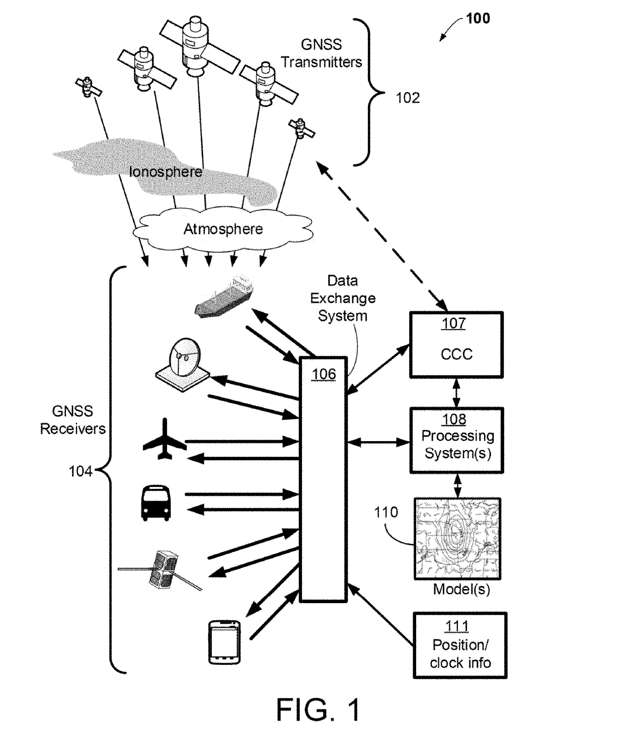
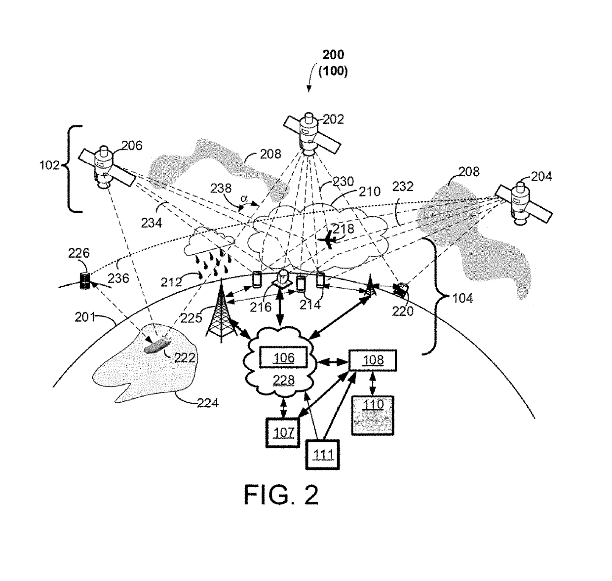
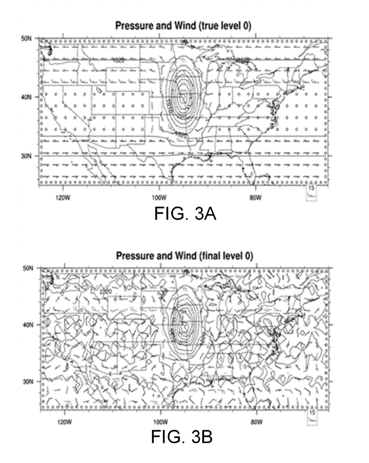
[0019]Some implementations of the disclosed technology will be described more fully hereinafter with reference to the accompanying drawings. This disclosed technology may however, be embodied in many different forms and should not be construed as limited to the implementations set forth herein. Some of the components illustrated in the accompanying figures are shown for illustration purposes only, and may or may not be drawn to scale. In the following detailed description, numerous specific details are set forth by way of examples to provide a thorough understanding of the relevant teachings. However, it should be apparent to those skilled in the art that the present teachings may be practiced without such details. In other instances, well known methods, procedures, components, and / or circuitry have been described at a relatively high-level, without detail, to avoid unnecessarily obscuring aspects of the present teachings.

[0020]The disclosed technology generally relates to systems a...


PUM


Abstract

The disclosed technology relates to systems and methods for determining three-dimensional atmospheric and ionospheric density using refraction of electromagnetic waves. A method is provided for receiving, at a processing system, and from a plurality of Global Navigation Satellite Systems (GNSS) stations, navigation data corresponding to computed positions of the plurality of GNSS stations. The method can further include determining, based at least in part on received navigation data and received GNSS transmitter information, ionosphere and atmosphere refractivity corresponding to intersections of two or more GNSS signals. The method can include calculating, based on the determined 3D density states, data fields of a model representing the three-3D density states. The method can include transmitting position adjustment data to calibrate a navigation position of at least one of the plurality of the GNSS stations based at least in part on the calculated data fields of the model.

Description

FIELD[0001]The disclosed technology relates to systems and methods for determining three-dimensional atmospheric and ionospheric density using refraction of electromagnetic waves. Improved atmospheric and ionosphere three-dimensional density fields are used to constrain errors in GNSS navigation devices, allowing more accurate estimate of location. Additionally, iterative improvements between three-dimensional refraction fields and GNSS locations provides improved atmospheric and space weather predictions, and improved GNSS location capabilities.BACKGROUND[0002]Global Navigation Satellite Systems (GNSS) are satellite systems that can include the United States' Global Positioning System (GPS), Russia's GLONASS, and the European Union's GALILEO. Such systems are used primarily in navigation applications, for example, to determine receiver positioning. GPS has been in operation since 1978 (globally since 1994) and was initially developed to provide precise positioning for military purp...

Claims


Application Information

Patent Timeline
IPC IPC(8): G01S19/07G01S19/08
CPCG01S19/07G01S19/08G01S19/258G01S19/072
Inventor MACDONALD, ALEXANDER E.PLATZER, PETER
Owner SPIRE GLOBAL
Why Eureka
Try Eureka