Wildfire discovery, monitoring, and response system using personal vehicles

a technology for monitoring and responding systems, applied in fire alarms, instruments, navigation instruments, etc., can solve the problems of reliance on human intervention, and increasing frequency, duration and intensity of wildfires, so as to reduce the risk and cost of wildfires, improve firefighting, and reduce the effect of human intervention

Inactive Publication Date: 2019-07-25
FORD GLOBAL TECH LLC
View PDF0 Cites 10 Cited by
  • Summary
  • Abstract
  • Description
  • Claims
  • Application Information

AI Technical Summary

Benefits of technology

[0006]This invention provides an early fire detection method utilizing scattered vehicles as a “net of mobile nodes.” It enhances fire-fighting by enabling low cost and pervasive data gathering to support the determination of fire location, size, direction, and estimated burn rates. It helps mitigate the risk and cost of wildfires by detecting a fire event while it is in a more controllable state. It shares information with vehicles in the region of the fire so they can take action, such as additional data gathering and detouring around any confirmed wildfires.
[0007]In preferred embodiments, 360-degree visible cameras, infrared cameras, Radar, and / or LiDAR sensing subsystems on a car capture surrounding images and process them for various assisted driving features. The various vehicle control subsystems record the images or other environmental parameters and, in addition to their vehicle control functions, examine them for a potential indication of a fire (e.g., using pattern recognition to examine the shape, strength, and source of a possible fire). When at least one sensing subsystem is triggered as detecting a potential fire event, a central onboard logic system collects relevant data from a plurality of sensing subsystems so that it can analyze the parameters (e.g., by classifying the images whether they show fire flames or smoke plumes using pattern-recognition software and by making other comparisons). Depending on the results, the data may be transmitted to a remote fire response center (i.e., monitoring station) for further analysis and actions. This vehicular-based sensing approach provides continuous monitoring in more areas simultaneously and enables an ability to send / display warnings locally to paired smart devices and remotely (cloud-based) to nearby vehicles and to the response center through V2X communication links. The invention also enables vehicles to quickly alter their routes if possible to avoid rapidly moving fires.

Problems solved by technology

Wildfires in forests and other natural areas are a well-recognized problem which have been increasing in frequency, duration, and intensity throughout the world.
Known systems have exhibited various shortcomings, such as, reliance on human intervention, relatively limited coverage, and very high cost.

Method used


Image

  • Wildfire discovery, monitoring, and response system using personal vehicles
  • Wildfire discovery, monitoring, and response system using personal vehicles
  • Wildfire discovery, monitoring, and response system using personal vehicles

Examples


Embodiment Construction

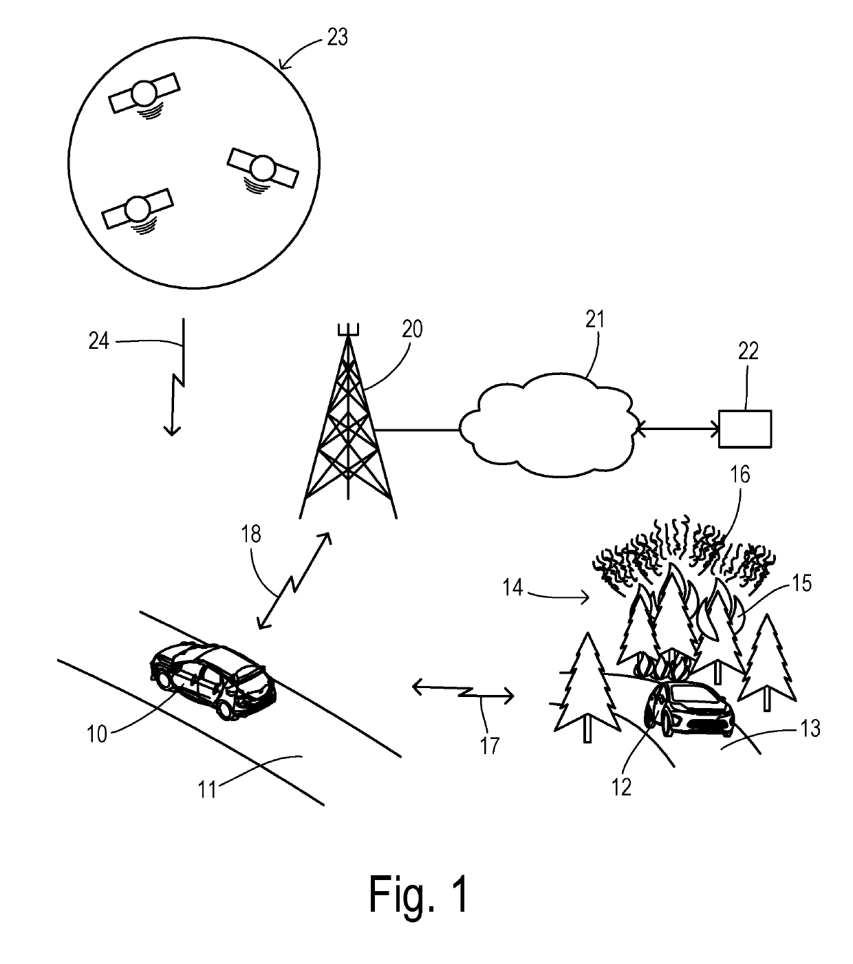
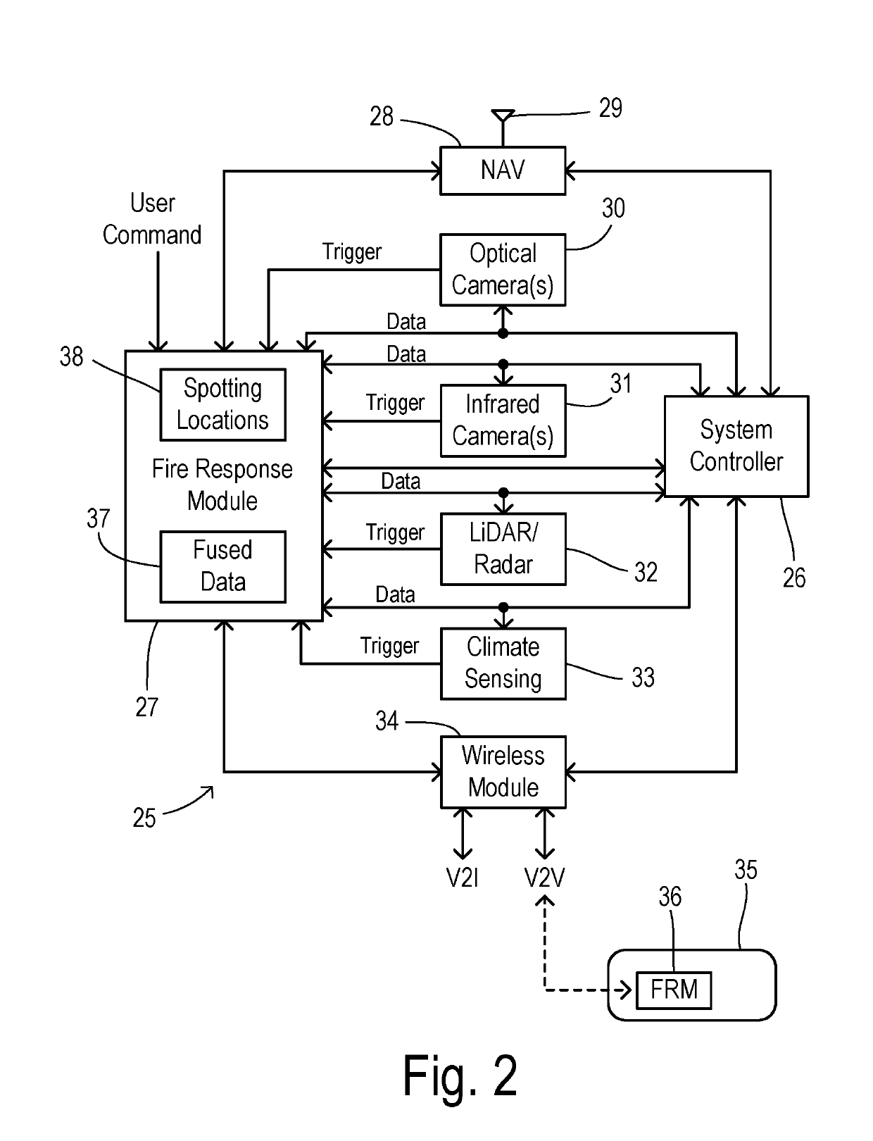
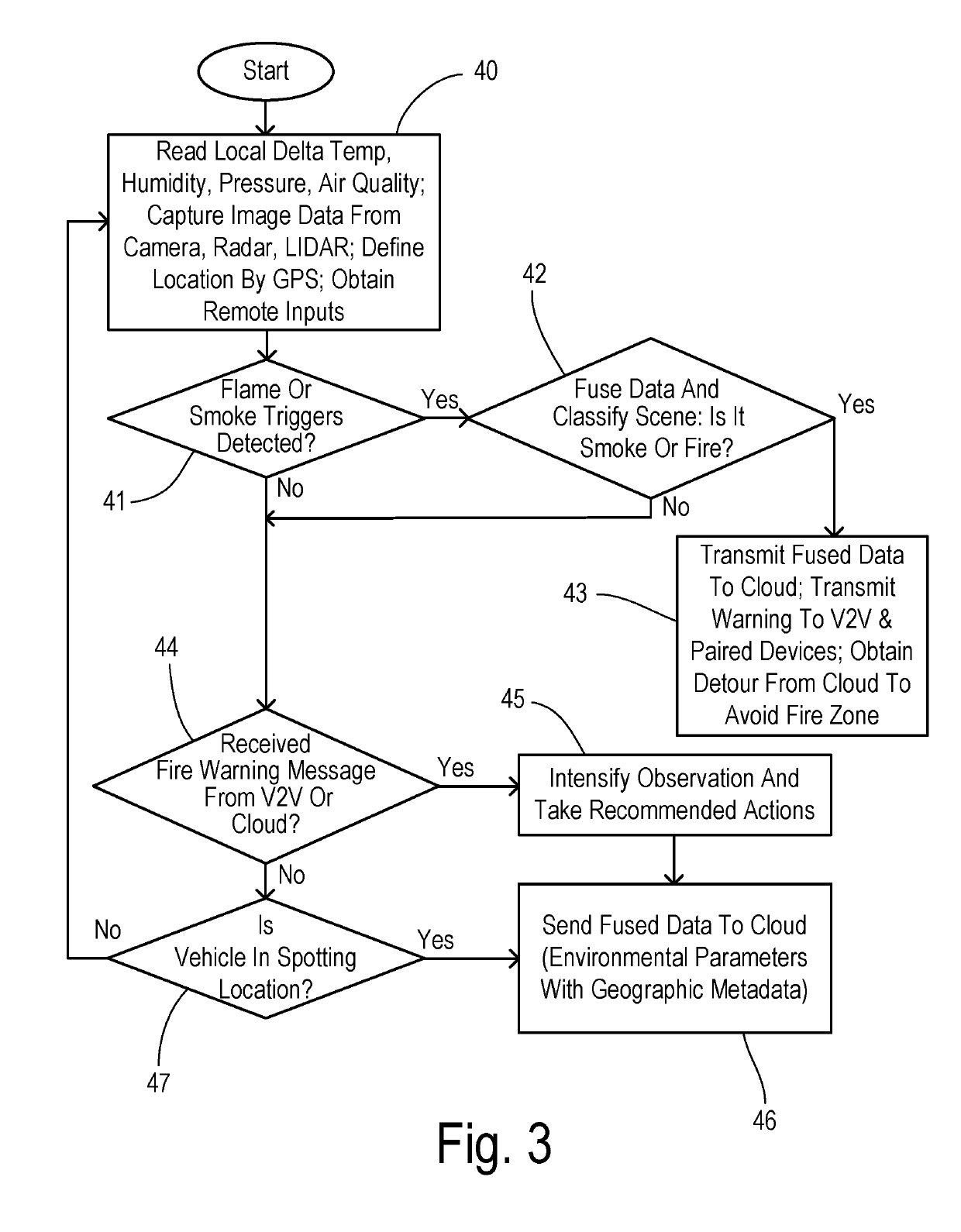
[0016]In some embodiments, vehicle image sensing and recognition systems detect the presence of smoke and / or fire, e.g., using the visible light spectrum of 360-degree cameras. These onboard systems have the advantage of continuous operation, relative proximity to potential sources of wildfires, and can support ongoing operations even after a fire is initially detected (e.g., in response to follow-up requests for data received from a response center). Using V2V networks for data transmission between vehicles (which remains stable even in remote areas), more extensive data sets with multiple camera images from multiple viewing locations and directions can confirm each other, which increases the robustness of discriminating smoke and flame. Moreover, the sensing subsystems and vehicle communication systems can execute the monitoring and signaling tasks without direct human intervention.

[0017]Given that GPS navigation systems are deployed as a standard feature in many vehicles that may...


PUM


Abstract

A distributed system detects and tracks wildfires using a fleet of automobiles as remote sensing systems. An individual vehicles includes a plurality of sensing subsystems each collecting and evaluating a respective environmental parameter for various autonomous functions such as collision avoidance, lane-keeping, and climate control. Each sensing subsystem analyzes a respective environmental parameter to detect a respective fire-related trigger. A fire response module in the vehicle responds to a respective fire-related trigger from one of the sensing subsystems by fusing data from a plurality of the sensing subsystems. The fire response module uses the fused data to detect whether there is a fire-related event. A wireless communication module communicates with a remote fire response center, and transmits the fused data to the fire response center when a fire-related event is detected. The response center sends notices and detour information for a confirmed fire incident to the wireless communication module.

Description

CROSS REFERENCE TO RELATED APPLICATIONS[0001]Not Applicable.STATEMENT REGARDING FEDERALLY SPONSORED RESEARCH[0002]Not Applicable.BACKGROUND OF THE INVENTION[0003]The present invention relates in general to wildfire detection, tracking, and response systems, and, more specifically, to onboard vehicle systems for gathering data characterizing potential fire events, for sharing the data, and for safely navigating away from confirmed fire events.[0004]Wildfires in forests and other natural areas are a well-recognized problem which have been increasing in frequency, duration, and intensity throughout the world. Current wildfire detection efforts have been based on dedicated ground-based visual and non-visual sensors in fixed locations or driven on customized vehicles as specialized instrument packages. Instruments are also deployed in aircraft and satellites. Known systems have exhibited various shortcomings, such as, reliance on human intervention, relatively limited coverage, and very ...

Claims


Application Information

Patent Timeline
Patent Type & Authority Applications(United States)
IPC IPC(8): G01C21/34G08G1/0967G08G1/0968G08B17/00G07C5/00
CPCG08G1/0967G08G1/0968G08B17/005G07C5/008G01C21/3415G01C21/3461G01D21/02G08B17/125G08B25/10G08G1/0112G08G1/096833G07C5/0841G08G1/0133G08G1/0141G08G1/096716G08G1/096741G08G1/096775G08G1/096791G08G1/096805G08G1/096811
Inventor GHANNAM, MAHMOUD Y.BENNIE, BRIANSCHONDORF, STEVEN Y.
Owner FORD GLOBAL TECH LLC
Why Eureka
Try Eureka