Automatic satellite telemetry, tracking and command system

a satellite and command system technology, applied in the field of automatic satellite telemetry and tracking and command, can solve the problems of uncontrollable unaffordable costs for satellite operators with limited economical resources, and inability to control leo satellites for most of their orbital time, so as to achieve cheaper costs and enhance coverage

Active Publication Date: 2020-01-23
TELESPAZIO SPA
View PDF2 Cites 14 Cited by
  • Summary
  • Abstract
  • Description
  • Claims
  • Application Information

AI Technical Summary

Benefits of technology

[0023]In particular, a specific object of the present invention is that of providing a system that is able to provide Telemetry, Tracking and Command (TT&C) services for LEO satellites, in particular small / micro / nano / pico / femto-satellites, without any necessity for orbital data provision from external sources, and with enhanced coverage and cheaper costs than current solutions.

Problems solved by technology

Therefore, LEO satellites are uncontrolled for most of their orbital time.
Anyway, the cost of a COTS-based ground station may reach several tens of thousands of euros.
Additionally, for the overall operating cost of one of these satellites, there should be considered also the expenses for management and maintenance of the ground station and for the staff there employed.
It is worth noting that these costs could be unaffordable for satellite operators with limited economical resources (e.g., universities and research centers).
Unfortunately, since these satellites are typically deployed in orbit with multiple release mechanisms as piggyback payload on board commercial launchers, their orbital data are known only after the identification and tracking made by the dedicated authorities.
However, the ever increasing number of small / micro / nano / pico / femto-satellites is posing extraordinary challenges to all authorities responsible for satellite identification and tracking.
Additionally, this approach relies only on the capability of the US-SSN to rapidly track, discriminate, and identify satellites.
However, the US-SSN TLEs do not guarantee a timely provision of needed input data to appropriately steer ground stations' antennas to establish communication links with the satellites.
Furthermore, it took several weeks before the USSTRATCOM performed identification of all the launched satellites.
Therefore, in view of the foregoing, a small / micro / nano / pico / femto-satellite is typically left completely uncontrolled, with related problems and risks, for a certain period (namely, until its orbital data become available).
Therefore, if a LEO small / micro / nano / pico / femto-satellite is not equipped with high speed data link means, the overall data amount transmitted to ground could be very limited.
However, the limit of these initiatives is the reliability and the stability of the single ground stations.
1) for a certain initial period, orbital data of a satellite are not known and the respective ground station cannot track and control the satellite;
2) even when the orbital data are known, for a LEO satellite the coverage period of a single ground station is only about 3% of the total satellite orbital time;
3) a ground station involves non-negligible costs that can be unaffordable for low-budget missions.
Moreover, if a LEO satellite, both of the traditional large type and of the small / micro / nano / pico / femto type, has a malfunction, it is detected only when the satellite pass over the respective ground station sending alert signals to ground, and this may occur after many hours, or even days, from malfunction occurrence.

Method used


Image

  • Automatic satellite telemetry, tracking and command system
  • Automatic satellite telemetry, tracking and command system
  • Automatic satellite telemetry, tracking and command system

Examples


Embodiment Construction

[0030]The following discussion is presented to enable a person skilled in the art to make and use the invention. Various modifications to the embodiments will be readily apparent to those skilled in the art, without departing from the scope of the present invention as claimed. Thence, the present invention is not intended to be limited to the embodiments shown and described, but is to be accorded the widest scope consistent with the principles and features disclosed herein and defined in the appended claims.

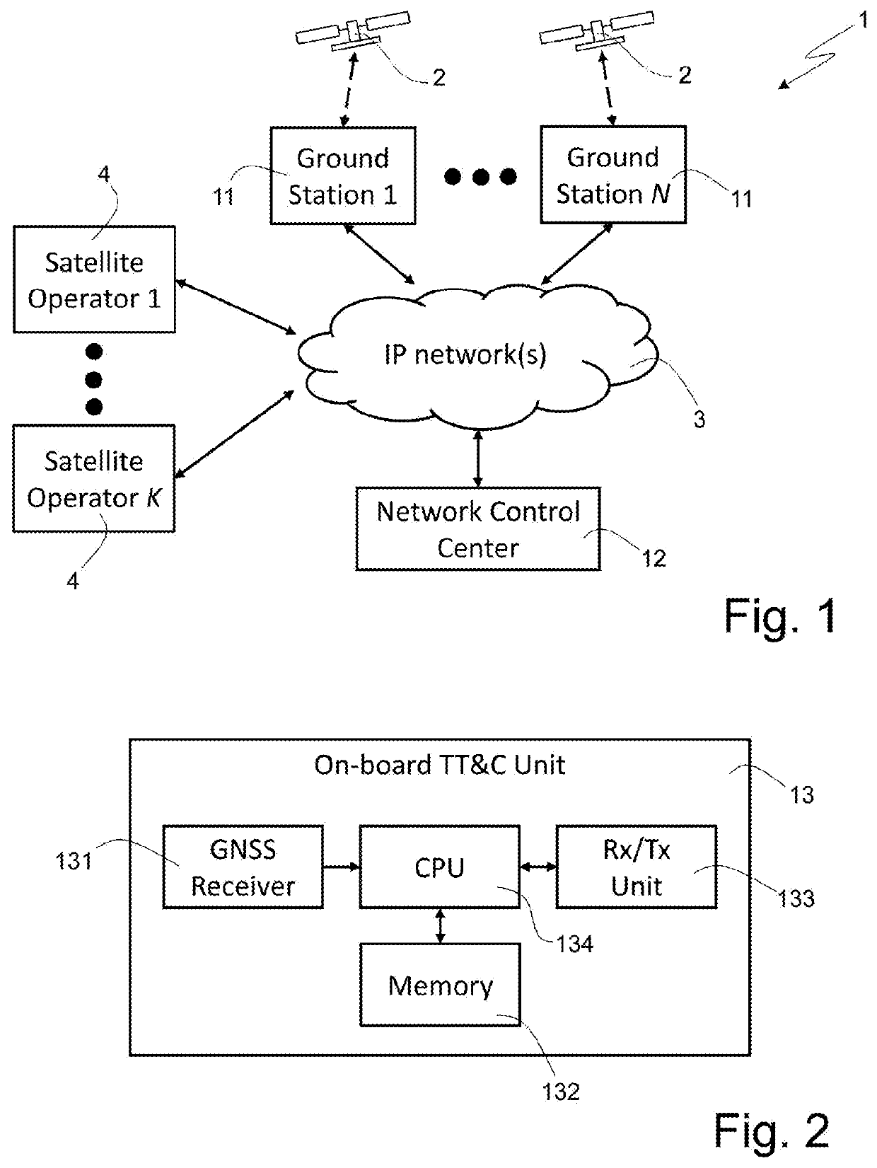
[0031]FIG. 1 schematically illustrates a satellite Telemetry, Tracking and Command (TT&C) system (denoted as a whole by 1) according to a preferred, non-limiting embodiment of the present invention.

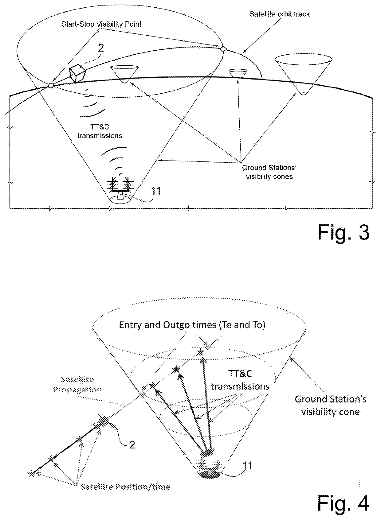
[0032]In particular, the satellite TT&C system 1 includes:[0033]a plurality of ground stations 11, each of which is located at a respective position on earth's surface and is designed to, when a satellite 2 is in a respective visibility region of the around station 11, receive downlink...


PUM


Abstract

The invention concerns a satellite telemetry, tracking and command system including ground stations, on-board units and a network control center. Each on-board unit is installed on board a respective satellite and is configured to compute a future orbital path of the satellite and determine when said respective satellite is within the visibility region of one of the ground stations on the basis of the satellite's positions and velocities computed and of the stored coverage data. When said respective satellite is within the visibility region of a ground station, the on-board unit may transmit to said ground station the downlink signals and receive therefrom the uplink signals; and carry out actions/operations corresponding to the commands received from the ground stations. The ground stations may be networked together and may send and receive information to and from the network control center.

Description

CROSS-REFERENCE TO RELATED APPLICATIONS[0001]This application claims priority from Italian Patent Application No. 102017000138364 filed on Nov. 30, 2017, the disclosure of which is incorporated by reference.TECHNICAL FIELD OF THE INVENTION[0002]The present invention concerns, in general, a system for satellite Telemetry, Tracking and Command (TT&C) applications. In particular, the present invention finds advantageous, although non-exclusive, application with the so-called small satellites, microsatellites, nanosatellites, picosatellites and femtosatellites, frequently made in the form of cubesats.STATE OF THE ART[0003]As is known, a satellite orbiting the earth sends telemetry data to, and receives commands from, a respective ground station located on earth's surface. Typically, a single ground station is able to cover about 3% of the orbit of a Low Earth Orbit (LEO) satellite. Therefore, LEO satellites are uncontrolled for most of their orbital time.[0004]In order to increase cover...

Claims


Application Information

Patent Timeline
Patent Type & Authority Applications(United States)
IPC IPC(8): B64G3/00G01S19/27G01S19/28
CPCB64G3/00G01S19/28G01S19/27G01S5/0009H04B7/18552H04B7/18515H04B7/18517H04B7/195
Inventor FORTEZZA, RAIMONDO
Owner TELESPAZIO SPA
Why Eureka
Try Eureka