Offline Method to Determine Location of a Vehicle Using Mobile Phones

Active Publication Date: 2021-01-21
GOOGLE LLC
View PDF0 Cites 1 Cited by
  • Summary
  • Abstract
  • Description
  • Claims
  • Application Information

AI Technical Summary

Benefits of technology

[0008]In view of the foregoing, an embodiment herein provides the user travelling the ability to choose a specific vehicle in a public transport system and a way to specify whether the user is inside or outside the vehicle. The method and system used in the invention stores the route information for a predetermined set of vehicles in the mobile device so that they are available offline during travel without needing Internet. The route information of a vehicle consists of the geographical path traversed by the vehicle along with the times at which the vehicle arrives/departs specific points along the route. For public transport like trains/buses, the route information for each individual train/bus is publicly known in a specific website or database. Though the route information may also change over time, they change at a frequency of several days. The method and system used in the invention is able to update the mobile phone with the latest route information, and this is done intelligently at times when the user is not travelling and when the mobile phone is connected to Internet. The method and system used in the invention further converts the publicly known route information into a form tha

Problems solved by technology

Furthermore, in many countries like India, the public transport like trains and buses have overnight journeys, which makes it more difficult for the passenger to determine the current location of the vehicle in a journey.
Moreover, these vehicles also get often delayed and don't run as per the known schedule which makes it even more important for passengers to know real-time location of the vehicle and plan accordingly.
However, in mobile phones, GPS based solutions do come with a cost.
They need lot of power and drain the battery very fast.
This is because GPS is a very slow communication channel.
It need to communicate with 3 or 4 satellites for an extended duration at nearly 50 bits per second that puts a huge load on the battery life of the mobile phone and particularly when a user is in a long-distance public transport where battery charge is vital, it is not viable to use GPS continuously to monitor location.
The other problem with GPS solutions is relating to the locking of the GPS signal.
This part takes several seconds and sometimes e

Method used


Image

  • Offline Method to Determine Location of a Vehicle Using Mobile Phones
  • Offline Method to Determine Location of a Vehicle Using Mobile Phones
  • Offline Method to Determine Location of a Vehicle Using Mobile Phones

Examples


Example

[0025]The embodiments herein and the various features and advantageous details thereof are explained more fully with reference to the non-limiting embodiments and detailed in the following description. Descriptions of well-known components and processing techniques are omitted so as to not unnecessarily obscure the embodiments herein. The examples used herein are intended merely to facilitate an understanding of ways in which the embodiments herein may be practiced and to further enable those of skill in the art to practice the embodiments herein. Accordingly, the examples should not be construed as limiting the scope of the embodiments herein.

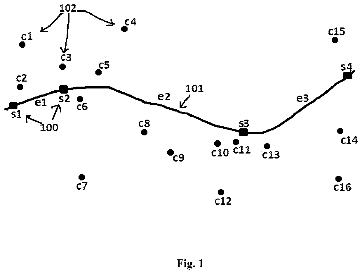
[0026]As mentioned above, there is a need to develop a technique that enables users inside a vehicle to find the location of the vehicle using mobile devices without the overhead of GPS or internet especially during commuting in public transport. The embodiments herein achieve this by locating cell towers around the route of the vehicle select...


PUM


Abstract

The present invention provides a method for determining real-time location of a vehicle using a mobile device without GPS for the user travelling inside the vehicle. According to the embodiment of the present invention, the location of the vehicle is determined using the locations of the cell-towers to which a mobile phone of a user is connected, and projects these cell tower locations onto the selected route of the user journey to obtain a closest point and thereby determining the user location. The invention also provides the real-time location of the vehicle over internet to users outside the vehicle by crowd-sourcing the cell-tower data of the passengers inside the vehicle.

Description

FIELD OF INVENTION[0001]The embodiments herein generally relates to a method and system of finding approximate location of a vehicle for a user using his / her mobile device. The invention is specifically applicable when a user travels in public transport where the set of routes and schedules are publicly known, and the user would like to view the dynamic location of a vehicle with or without the need of Internet.BACKGROUND AND PRIOR ART[0002]Passengers travelling in public transports have great tendency to frequently know the location of the vehicle with respect to the journey. In many countries, the exact location of the vehicle is not displayed to the passengers in the vehicle. Furthermore, in many countries like India, the public transport like trains and buses have overnight journeys, which makes it more difficult for the passenger to determine the current location of the vehicle in a journey. Moreover, these vehicles also get often delayed and don't run as per the known schedule...

Claims


Application Information

Patent Timeline
IPC IPC(8): H04W4/029H04W4/02
CPCH04W4/029H04W84/042H04W4/023G08G1/123H04W64/00G01S5/14G01S5/02695G01S5/0295
Inventor MOHAIDEEN PATHURUDEEN, AHMED NIZAMVENKATARAMAN, SASHIKUMARSUNDARAM, MEENAKSHIRAJENDRAN SURIYAKALA, BALASUBRAMONIAMNAGARAJAN, ARUN KUMAR
Owner GOOGLE LLC
Why Eureka
Try Eureka