Communication navigation system

a communication navigation and system technology, applied in the field of communication navigation system, can solve the problems of user owing high communication costs, navigation apparatus not being able to determine a road link, navigation apparatus not having the same road link database,

Inactive Publication Date: 2003-04-01
EQUOS RES
View PDF16 Cites 67 Cited by
  • Summary
  • Abstract
  • Description
  • Claims
  • Application Information

AI Technical Summary

Problems solved by technology

However, although the information center has the latest road links database, the navigation apparatus may not have a road link database same as in the information center.
In such a case, the navigation apparatus is not able to determine a road link alon

Method used


Image

  • Communication navigation system
  • Communication navigation system
  • Communication navigation system

Examples


first embodiment

(1) Summary of First Embodiment

In a first embodiment, the crossing specifying data received from an external device is used to generate corresponding route data, by which route guidance is executed.

In this embodiment, a route may be determined even when the navigation apparatus has no crossing or road data corresponding to the route data acquired from the external device, so that route guidance may be executed.

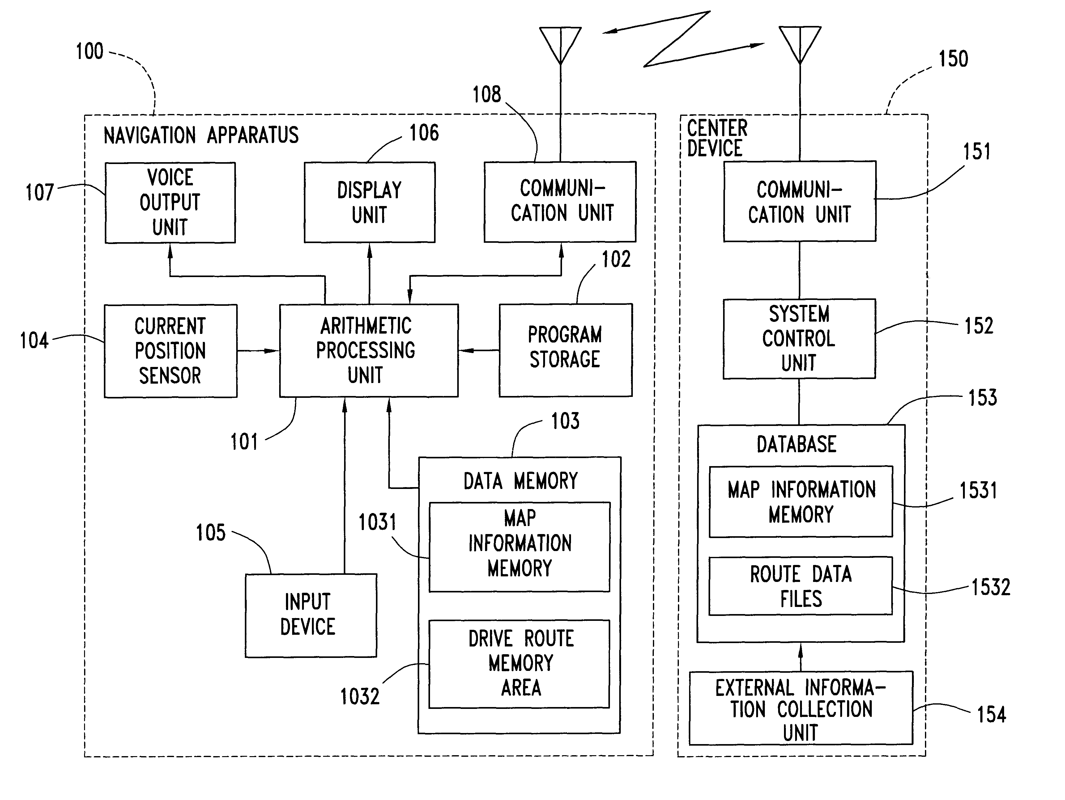
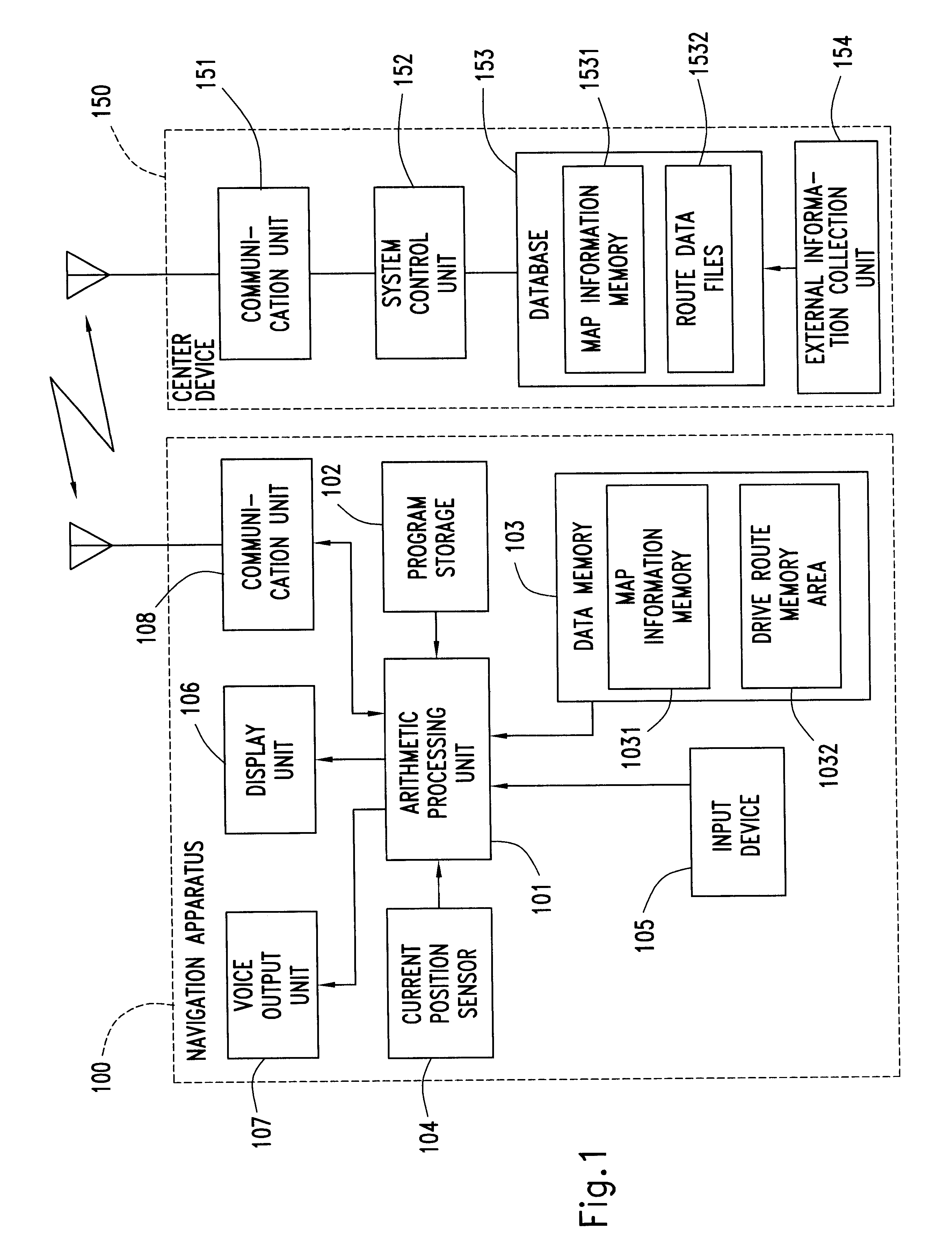
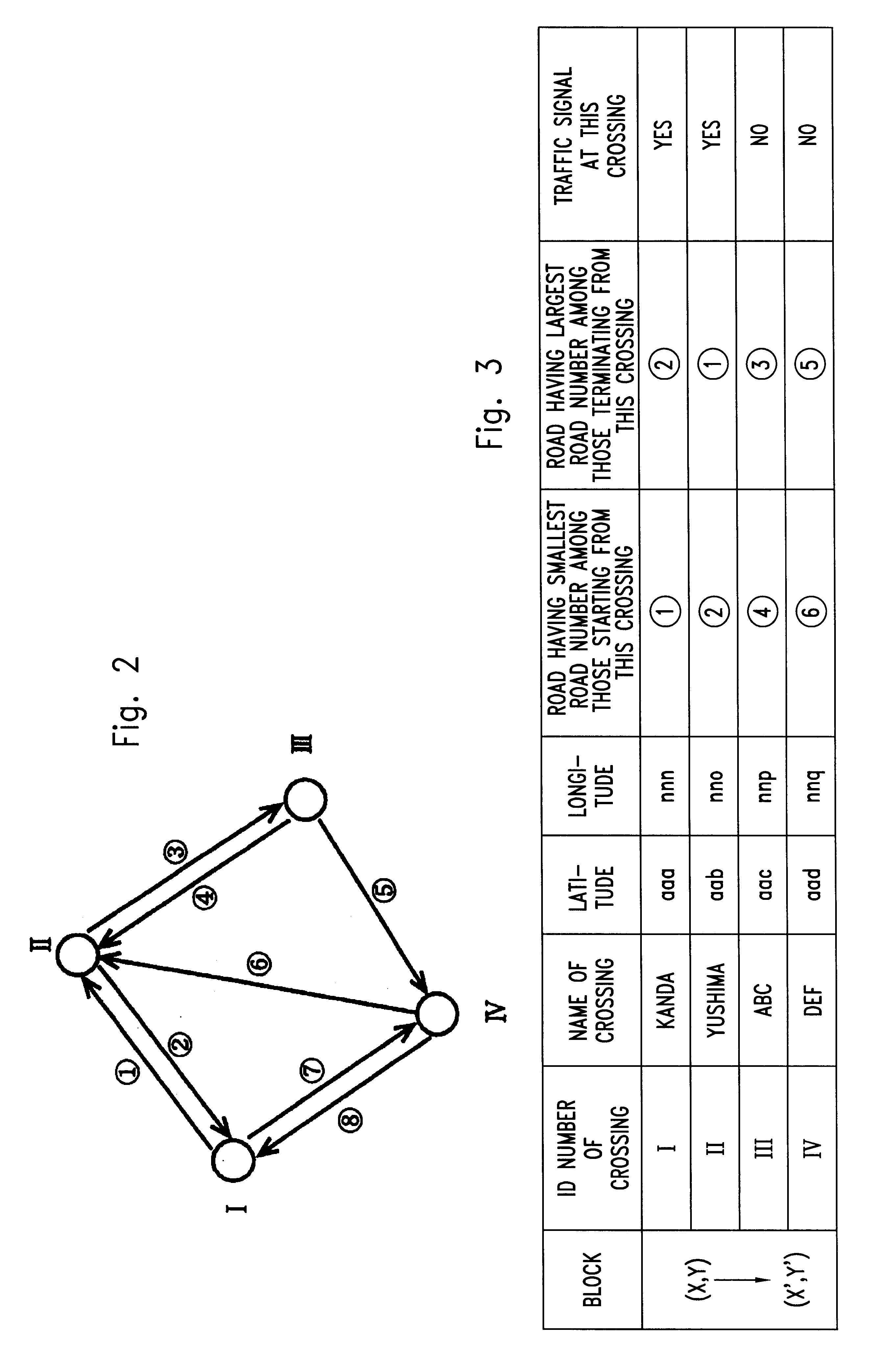
In this embodiment, the information center searches a recommended route to a destination which is transmitted from the navigation apparatus, and extracts crossings located on the recommended route to prepare the crossing specifying data which comprises a series of coordinates of the on-route crossings. The crossing specifying data is transmitted to the navigation apparatus.

After transmitting the destination to the information center, the navigation apparatus receives the crossing specifying data. The navigation apparatus then matches the coordinates of the on-route crossings c...

second embodiment

(3) Summary of Second Embodiment

The second embodiment also relates to a communication navigation system wherein a navigation apparatus 100 mounted on a vehicle communicates with a center device 150 in an information center so that the navigation apparatus 100 executes route guidance operation with the help of information transmitted from the center device 150.

In accordance with the second embodiment, in a system wherein the center device 150 (i.e., a communicatory information center) executes route searching operation, the result of which is transmitted to the navigation apparatus 100 (i.e., a communicatory mobile data-processing unit mounted on the vehicle), it is possible to execute the route guidance operation even if there is a version difference between the road information stored in the navigation apparatus 100 and the road information stored in the center device 150. More particularly, the navigation apparatus 100 transmits version data of the road information stored it the n...


PUM


Abstract

A communication navigation system, wherein a navigation apparatus requests a recommended route guidance data to a information center and guides a user of the navigation apparatus to a destination by using the recommended route guidance data received from the information center.In this present invention, the navigation apparatus transmits version data of road data held in the navigation apparatus at the request to the information center. The information center prepares a guidance data of recommended route using latest road data held in the information center, and transmits the data to the navigation apparatus. When the information center transmits the guidance data, the information center selects the type of data of the road links along the recommended route, in the guidance data, by comparing the version data received from the navigation apparatus and the version data of each road link along the recommended route. If each data of road links along the recommended route is considered to be contained in the road data held in the navigation apparatus, the information center transmits the only data which enable to specify the road link from the road data held in the navigation apparatus. On the hand, if each data of road links is considered not to be contained in the road data held in the navigation apparatus, the information center transmits whole data of the road link. Therefore, the navigation apparatus can generate the route guidance data by extracting road link data, from its own road data, corresponding to the road link specified by transmitted data and by reconstructing road link data using transmitted data.

Description

The present invention relates to a navigation system for guiding a user of a navigation apparatus from a current location to a destination and, more particularly to a communication navigation system wherein a navigation apparatus mounted on a vehicle receives a drive route to a destination from an information center or an external device by communication therebetween.BACKGROUND OF THE ARTA navigation system has been widely used in a vehicle to provide a recommended route from a current location to a destination, along which a user of the system may drive the vehicle. The navigation system stores destination data, road link data and map data. The road link data is used for searching for a route from the current location to the destination. The current location of the vehicle is detected by a GPS receiver, for example. The systems refers to the current vehicle location and the searched route to guide the user by showing the direction which the user should head off or by giving instruc...

Claims


Application Information

Patent Timeline
IPC IPC(8): G01C21/34G09B29/00G01C21/00G08G1/09G08G1/0969G08G1/137G09B29/10H04B7/26
CPCG01C21/32G01C21/3629G01C21/3492G01C21/3889G01C21/3815G01C21/3896
Inventor ITO, YASUOGORAI, NAOKISUGAWARA, TAKASHIKITANO, SATOSHIYAMAKAWA, HIROYUKI
Owner EQUOS RES
Why Eureka
Try Eureka