Cellular telephone system that uses position of a mobile unit to make call management decisions

a mobile unit and cellular telephone technology, applied in the field of wireless over the air communication, can solve the problems of insufficient coverage, no coverage, complicated geographical area, etc., and achieve the effect of efficient and accurate service to a mobile uni

Inactive Publication Date: 2005-01-25
EMSAT ADVANCED GEO LOCATION TECH
View PDF76 Cites 282 Cited by
  • Summary
  • Abstract
  • Description
  • Claims
  • Application Information

AI Technical Summary

Benefits of technology

It is a main object of the present invention to provide a wireless over-the-air communications system that will permit a wireless communication system to determine the most efficient and accurate service to a mobile unit.
These, and other, objects are achieved by a CMR system that allows the Exact Geographic Location (EGL) of a communications device to be tracked and compared to geographic land data and information data and to continuously update this information during the communication process whereby the proper and most efficient service is provided, including proper communication process management and billing decisions. Within the scope of this invention is the ability to solve the above-mentioned problems and achieve the above-mentioned objects. By knowing the exact geographic location of a mobile unit during a communication process, competing service providers can locate their cell sites anywhere where the wireless reception will allow them to provide the best wireless coverage of their territory. The cell sites can even have overlapping coverage, or be inside an adjacent wireless communication system's coverage area. By knowing the location of the calling device at all times during the communication process, the wireless over-the-air communication system can configure the system to work together with other systems and wireless communication systems to process a communication process correctly. Service can be provided by the proper licensed wireless communication system because the exact location of the mobile unit is known at all times during the communication process. Propagation patterns and the like are not needed.

Problems solved by technology

Any particular geographic area can become quite complicated with cells overlapping each other, and overlapping cells of other neighboring cellular systems.
Further, null zones with inadequate coverage, or even no coverage, can result.
Since wireless propagation does not end at exact geographic boundaries, many conflicts have arisen between service providers as to which service provider should provide service at the location from where the Communication Process (CP) is being originated or received.
Today, there are no methods or procedures to resolve these issues.
This created service voids between major metropolitan markets.
Today, as rural systems fill in the patchwork of nationwide coverage, network service provision boundary disputes are becoming common.
The methods used to match the system boundaries to the geographic boundaries are not entirely successful due to the variations in terrain, environment and limitations of antenna design and wireless propagation.
A common result of these problems is inadequate wireless signal strength or null coverage and border disputes around the geographic boundaries and hence poor service.
This presents substantial challenges when choosing sites in which to place wireless transmit / receive antennas.
Additionally, with real estate values being very high in established communities, cell sites are harder to construct and more expensive to build.
This in turn creates problems with overlapping coverage between wireless systems and thus disputes over which wireless system handles the communication process.
Another area that would be affected by this is problems of quality service.
This is because the service provider has conflicting requirements.
However, at the present time, presently available systems do not permit this type of coverage.
Some areas inherently have wireless propagation problems, such as service areas next to bodies of water or in steep valleys.
Wireless propagation can provide some very undesirable results for a number of reasons, some of which have been mentioned above and in the incorporated material.
Since cellular system geographic borders can be non-linear and can have irregular shapes, problems can arise.
These null zones will have either poor quality service or even no service at all, thereby resulting in poor service.
The result is that subscriber's Communication Process (CP) may not be processed by the correct service provider.
With a bluff on either side of the river, the cells can only service the opposite bluff.
This issue denies revenue to the wireless communication system that has legal right to serve the subscribers within its licensed geographic service boundaries.
Prior art systems are incapable of determining the geographic location of both the communications devices and their service boundaries and thus compromise quality of coverage.
Prior art systems cannot fully account for this.
Still further, if there is a service problem with a mobile unit, prior art systems are not able to accurately identify the exact geographic location of the unit when the problem arose.
This makes it difficult for the network to pinpoint coverage problems.
However, signal strength from one cell site does not provide such location information with sufficient accuracy to be of the best assistance to law enforcement agencies.

Method used


Image

  • Cellular telephone system that uses position of a mobile unit to make call management decisions
  • Cellular telephone system that uses position of a mobile unit to make call management decisions
  • Cellular telephone system that uses position of a mobile unit to make call management decisions

Examples


Embodiment Construction

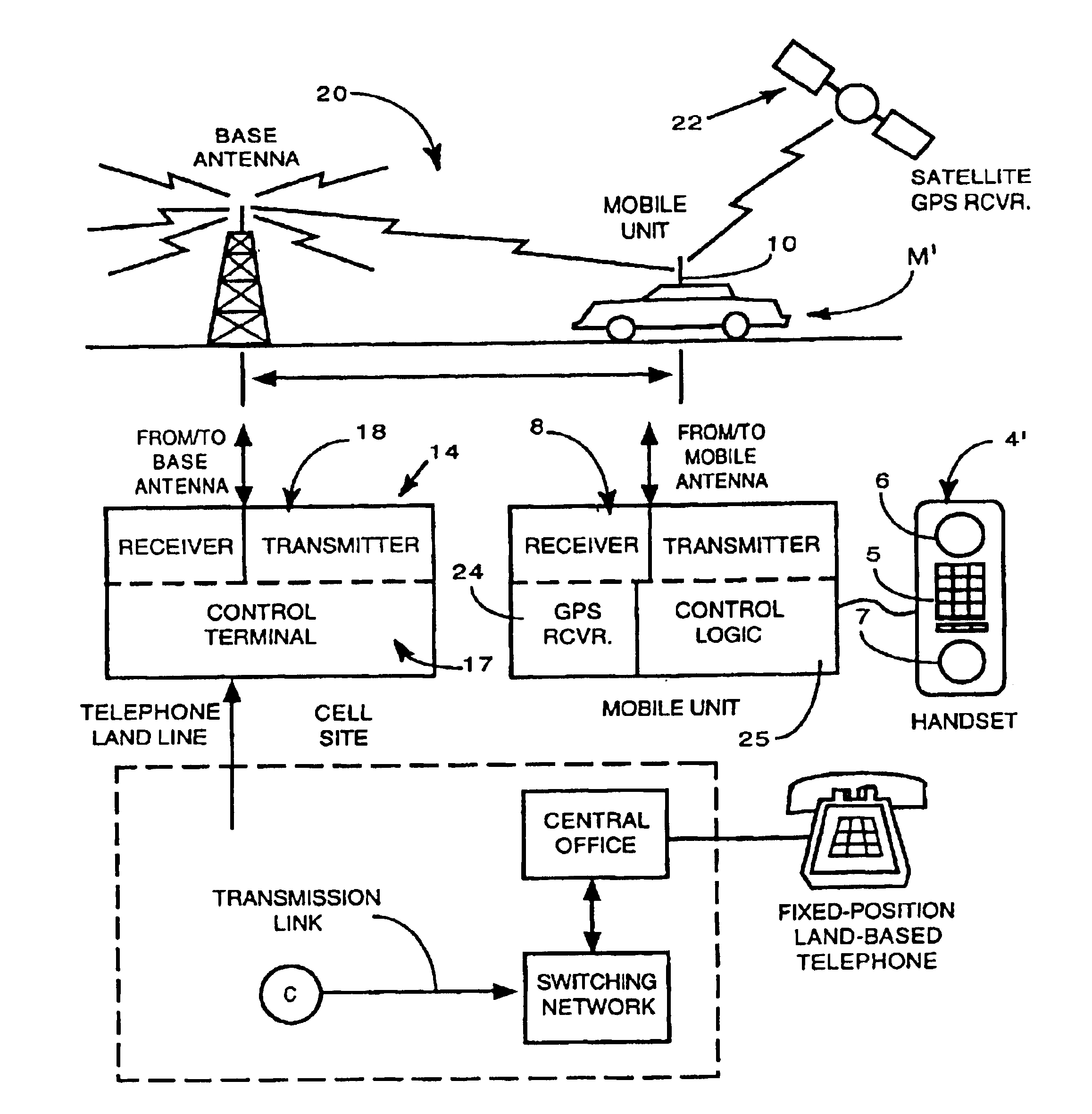
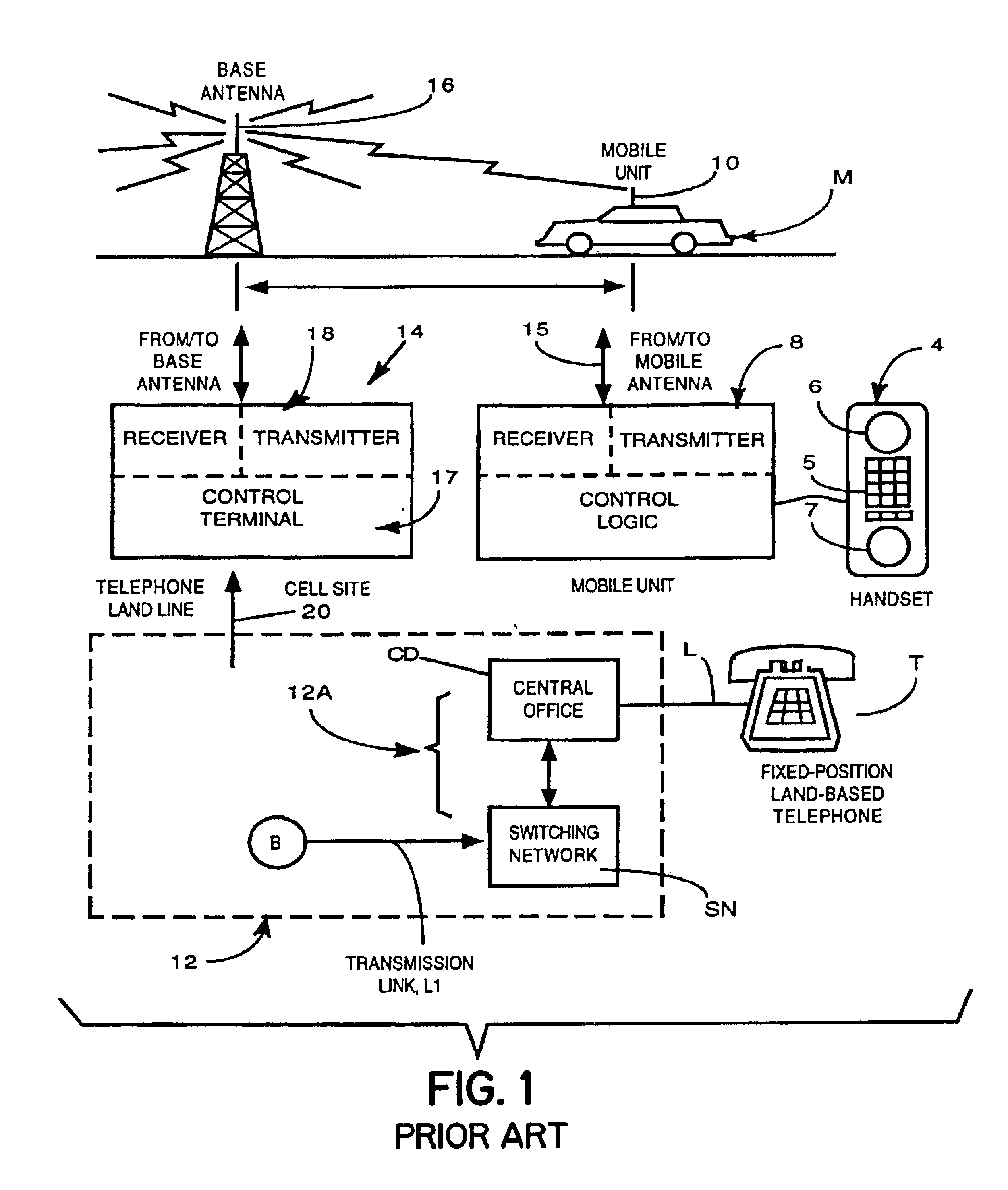
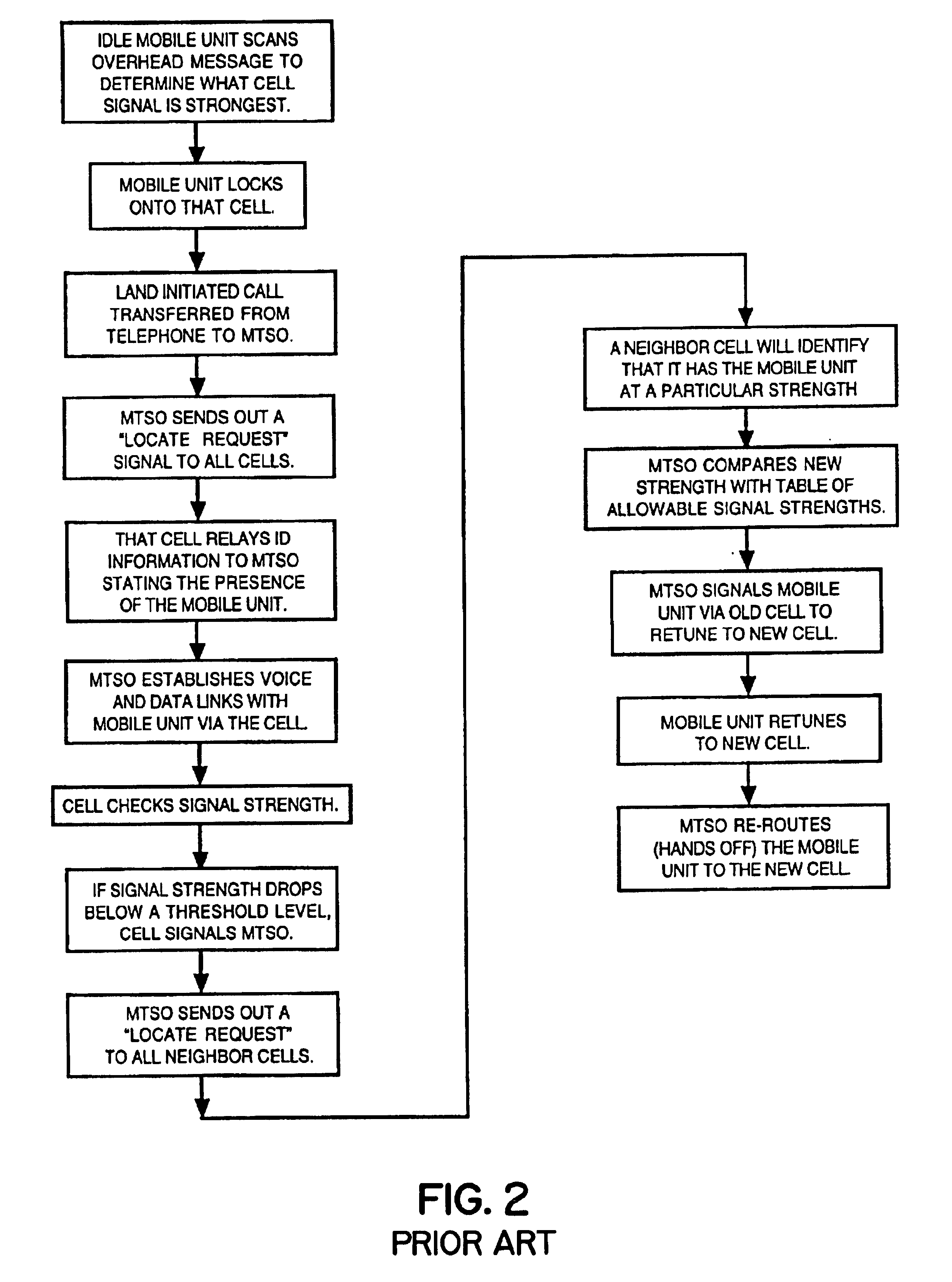
A representation of the logical flow that may occur in a wireless communications system incorporating the use of exact geographic location (EGL) for the communication process management decisions is shown in FIGS. 8-10. The communication process management decisions are based on information provided by the communication device (CD) towards the fixed system and to the communications device from the fixed system. The description of a sample communications process (CP) begins upon the powering up of the communicating device and continues until that communications process is completed.

When a communications device is powered up, block 101, the registration process, block 102 is initiated. The registration process is detailed in FIG. 9. The first step in the registration process, block 102 is to determine the exact geographic location, block 201 of the communications device via either GPS, block 202, signal strength, block 203, Loran, block 204, triangulation or other similar location mea...


PUM


Abstract

A cellular telephone system has call management decisions made based on the exact geographic location of the mobile unit. These call management decisions include billing and taxing decisions, cell site selection, frequency selection and even cellular system selection. The decisions are continuously updated during a call whereby decisions can be made and changed regardless of where a call originated. Cell site location, and even cellular system selection, can be made in a specific manner to best serve the needs of the mobile user, the cellular system as well as the public. It is even possible for a cellular system to locate one or more of its cell sites in the geographic area served by another cellular system. In some cases, cellular systems might even share cell sites.

Description

TECHNICAL FIELD OF THE INVENTIONThe present invention relates to the general art of wireless over-the-air communication, which includes cellular mobile radiotelephone (CMR) technology, and to the particular field of managing communication processes in a wireless over-the-air communication system. The present application is a continuation-in-part of pending U.S. application Ser. No. 08 / 555,884, filed Oct. 23, 1995 which is a continuation-in-part of U.S. application Ser. No. 08 / 402,976, filed Mar. 13, 1995, which was a CIP of U.S. application Ser. No. 07 / 813,495, filed Dec. 26, 1991, which is a continuation of U.S. application Ser. No. 08 / 057,833, filed May 7, 1993 which is a continuation of U.S. application Ser. No. 07 / 813,494, filed Dec. 26, 1991 and issued as U.S. Pat. No. 5,235,633. The disclosures of each of these applications is fully incorporated herein by reference. Therefore, as used hereinafter, the term “prior art” refers to art that is relevant prior to the invention dates...

Claims


Application Information

Patent Timeline
Patent Type & Authority Patents(United States)
IPC IPC(8): H04B7/185H04Q7/22H04Q7/38H04W4/02H04W4/029H04W4/90H04W36/32H04W76/04
CPCH04B7/18541H04B7/18552H04W4/02H04W76/007H04W4/22H04W76/04H04W36/32H04W64/00H04W76/50H04W4/90H04W76/20H04W36/322H04W4/029
Inventor DENNISON, EVERETTDUFFY, TIMOTHY J.PAULEY, GREGORY TJONES, SCOTT L.PHARIS, JR., ALBERT H.WILLIAMSON, IV, WARREN P.
Owner EMSAT ADVANCED GEO LOCATION TECH
Why Eureka
Try Eureka