Methods and systems for detecting forward obstacles

a technology of forward obstacles and detection methods, applied in the field of radar altimeters, can solve the problems of increasing the probability, not being able to detect objects, and still flying into certain terrain,

Inactive Publication Date: 2005-04-26
HONEYWELL INT INC
View PDF7 Cites 52 Cited by
  • Summary
  • Abstract
  • Description
  • Claims
  • Application Information

AI Technical Summary

Benefits of technology

[0009]In one aspect, a method for detecting obstacles in the forward flight path of an air vehicle is provided. The air vehicle utilizes a radar altimeter and an electronic digital elevation map for precision terrain aided navigation, and the radar altimeter incorporates a forward looking antenna. The method comprises determining a position of the air vehicle on the digital elevation map, selecting an area of the digital elevation map in the flight path of the air vehicle, based at least in part on the determined air vehicle position, and scanning the terrain representing the selected map area with the forward looking antenna. The method also comprises combining the digital elevation map data for the selected area with radar return data for the scanned, selected area and displaying the combined data to provide a representation of the terrain and obstacles in the forward flight path of the air vehicle.
[0010]In another aspect, a radar altimeter is provided. The radar altimeter comprises a precision terrain aided navigation (PTAN) processor configured to process interferometric radar altimeter data, a terrain correlation processor configured to correlate data from the PTAN processor to a present vehicle location on a digital elevation map (DEM), and a forward map scanning processor configure

Problems solved by technology

However, problems still exist with flights into certain terrain.
Flying at such low altitudes increases the probability that certain terrain features are in front of the aircraft, in the flight path, rather than safely below the aircraft, as is the case at normal flight altitudes.
Radar altimeters are generally incapable of detecting objects that are in a flight path.
While an aircraft equipped with a radar altimeter can determine an altitude, the aircraft is not able to determine the presence of objects in front of the aircraf

Method used


Image

  • Methods and systems for detecting forward obstacles
  • Methods and systems for detecting forward obstacles
  • Methods and systems for detecting forward obstacles

Examples


Embodiment Construction

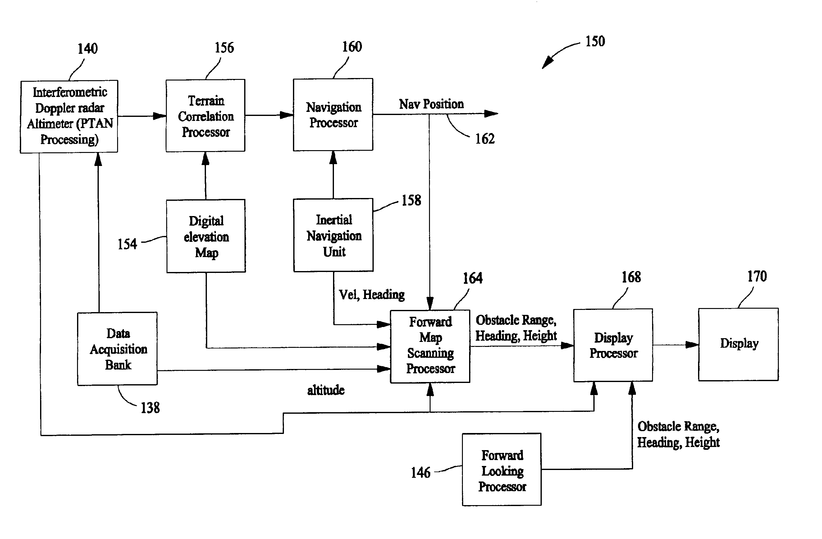
[0017]A radar altimeter which provides a forward looking capability is herein described. Precision terrain aided navigation (PTAN) allows correlation of radar ground return data with a digital elevation map (DEM), resulting in a position update to a navigation system. Such navigation systems typically will incorporate at least two sources of navigation information in providing a position solution. For example, an inertial navigation unit, for example, along with a radar altimeter incorporating PTAN capability, will provide a navigation solution. In such a scenario, position updates based on radar are used to subtract out drift errors generated by an inertial sensor of the inertial navigation unit, resulting in highly accurate navigation position capability. The success of poor visibility, low flying missions depends not only on a system like a radar altimeter with PTAN capability to provide an exact vehicle location on the DEM, but also the ability to determine the existence of obst...


PUM


Abstract

Methods and apparatus for detecting obstacles in the flight path of an air vehicle are described. The air vehicle utilizes a radar altimeter incorporating a forward looking antenna and an electronic digital elevation map to provide precision terrain aided navigation. The method comprises determining a position of the air vehicle on the digital elevation map, selecting an area of the digital elevation map in the flight path of the air vehicle, based at least in part on the determined air vehicle position, and scanning the terrain representing the selected map area with the forward looking antenna. The method also comprises combining the digital elevation map data for the selected map area with radar return data for the scanned, selected area and displaying the combined data to provide a representation of the terrain and obstacles in the forward flight path of the air vehicle.

Description

CROSS REFERENCE TO RELATED APPLICATIONS[0001]This application claims priority of Provisional Application Ser. No. 60 / 560,292 filed Apr. 6, 2004.BACKGROUND OF THE INVENTION[0002]This invention relates generally to radar altimeters, and more specifically to a radar altimeter with a forward looking capability.[0003]The proper navigation of an aircraft in all phases of its flight is based, to a large extent, upon the ability to determine the terrain over which it is passing, and further based on the ability to determine a position of the aircraft. In this regard, aircraft instrumentation, sensors, radar systems, and specifically, radar altimeters are used in combination with electronic terrain maps. The electronic terrain maps (sometimes referred to as digital elevation maps or DEMs) provide the height (elevation) of objects on the map, and together with the radar altimeter, aid in the flight and the planning of a flight path for the aircraft.[0004]As such, radar altimeters are commonly...

Claims


Application Information

Patent Timeline
IPC IPC(8): G01C21/00G01S13/94G01S13/00G01S13/28G01S13/88G01S13/42G01S13/935
CPCG01S13/288G01S13/94G01S13/882G01S13/426G01S13/935
Inventor HAGER, JAMES R.ALMSTED, LARRY D.BECKER, ROBERT C.
Owner HONEYWELL INT INC
Why Eureka
Try Eureka