
Road status data providing system

a technology of road status and data providing system, which is applied in the field of road status data providing system, can solve the problems of insufficient ascertion, road jamming with vehicles, and inability to accurately ascertain whether the traffic jam is real or no

Inactive Publication Date: 2006-05-16
PIONEER CORP
View PDF18 Cites 32 Cited by
  • Summary
  • Abstract
  • Description
  • Claims
  • Application Information

AI Technical Summary

Benefits of technology

[0022]In accordance with configuration, a navigation function is added and the set destination data can be used for totaling the number of vehicles running toward the prescribed point, thereby realizing more accurately totaling.
[0027]In accordance with this configuration, the destination of the vehicle which has not set the destination can be estimated on the basis of the present position information transmitted at regular intervals and the past history information of the vehicle to estimate the route corresponding to the estimated destination, thereby acquiring a reasonable totaling result.
[0040]In accordance with the configuration, a navigation function is added and the set destination data can be used for totaling the number of vehicles running toward the prescribed point, thereby realizing more accurately totaling.
[0051]In accordance with this configuration, the user can create the status data requesting information which includes position information for indicating the prescribed point, range information for specifying a prescribed range inclusive of the point and time information for setting a time when the status data is to be acquired, thereby easily requesting the server to provide the road status data.

Problems solved by technology

The conventional display of a traffic jam status has a problem that it cannot be sufficiently ascertained whether the traffic jam on the same road should be attributable to the vehicles running toward the same destination or different destinations.
For example, it is assumed that in the case of going to an amusement facility, the road is jammed with vehicles.
In this case, it cannot be exactly ascertained whether the traffic jam is attributable to the vehicles going to the pleasure facility, a place farther than it or another place nearer than it.

Method used


Image

  • Road status data providing system
  • Road status data providing system
  • Road status data providing system

Examples


Embodiment Construction

[0071]Now referring to the drawings, an explanation will be given of the configuration and operation of this invention.

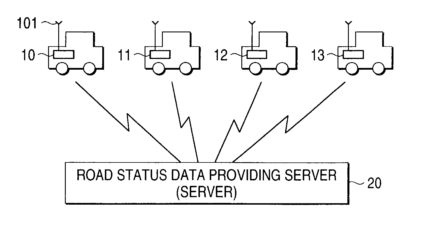
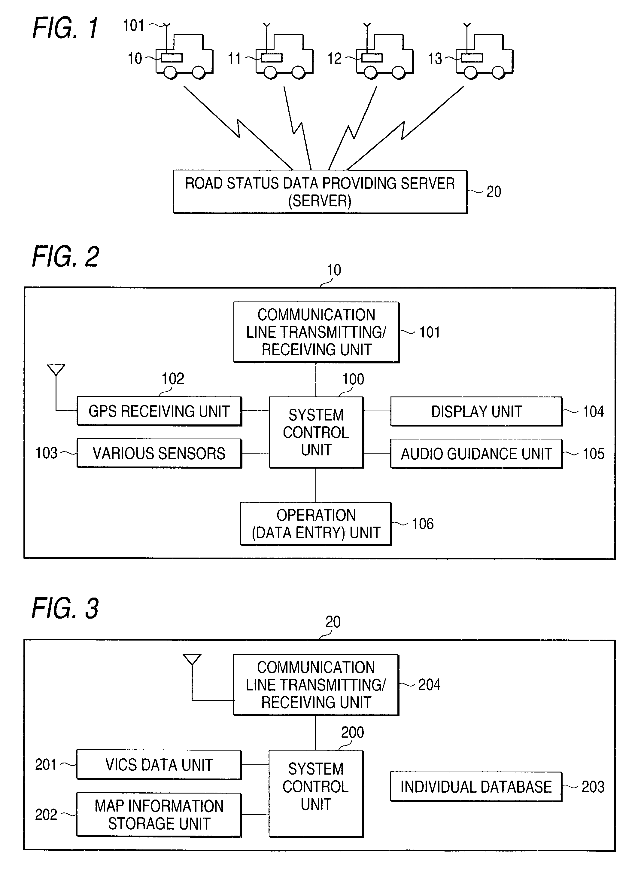
[0072]FIG. 1 is a view showing the entire hardware configuration of a road status data providing system according to this invention.

[0073]In FIG. 1, reference numeral 20 denotes a road status data providing system managing center (server) that is being managed by an enterprise which manages the road status data providing system according to this invention.

[0074]Reference numerals 10, 11, 12 and 13 denote terminals for the road status data providing system, which are installed on vehicles, respectively. Theses terminals are connected to the road status data providing system managing center 20 via a communication network (inclusive of wireless communication by radio waves or optical communication).

[0075]FIG. 2 is a block diagram showing the arrangement of the terminal which is mounted on a vehicle and used for the road status data providing system.

[0076]In FIG. 2, ref...


PUM


Abstract

A road status data providing system includes a server for transmitting / receiving data via a communication line and a plurality of vehicle terminals. The server includes a transmitting / receiving unit for transmitting / receiving data to and from the plurality of vehicle terminals, a vehicle trend management database for managing vehicle trends of the plurality of vehicle terminals, and a totaling unit for totaling status data indicative of a status of vehicles at a prescribed point on the basis of the vehicle trend management database. Each of the vehicle terminals includes a transmitting / receiving unit for transmitting / receiving data to and from the server, a present position determining unit for determining the present position of the vehicle, and a creating unit for creating status data requesting information for acquiring the status data at the prescribed point.

Description

CROSS REFERENCE OF RELATED APPLICATION[0001]This application is based on and claims priority under 35 U.S.C. §119 with respect to Japanese Patent Application No. 2001-333230 filed on Oct. 30, 2001, the entire content of which is incorporated herein by reference.BACKGROUND OF THE INVENTION[0002]1. Field of the Invention[0003]This invention relates to a road status data providing system, and a server and a vehicle terminal for providing road status data.[0004]2. Description of the Related Art[0005]A conventional navigation device is mounted in a vehicle (mounted in shipment of the vehicle or installed afterwards) and generally executes road navigation for each vehicle using map data and a program for running a system which are stored in a large scale storage device such as a CD (COMPACT DISC), DVD (DIGITAL VERSATILE DISC or DIGITAL VIDEODISC), or HDD (HARD DISK DRIVE), etc.[0006]Some conventional navigation devices are given a communication function based on a system such as VICS (VEH...

Claims


Application Information

Patent Timeline
IPC IPC(8): G01C21/34G08G1/00G01C21/00G08G1/01G08G1/09G08G1/0968G08G1/0969
CPCG08G1/0104G08G1/096844G08G1/096838G08G1/096811
Inventor WATANABE, TOMOODA, TAMAMISATO, TSUYOSHISAITO, YUKITAKA
Owner PIONEER CORP
Learn More