System for producing high-resolution, real-time synthetic meteorological conditions for a specified location

a meteorological condition and real-time synthetic technology, applied in the field of weather data or content analysis, can solve the problems of poor resolution of sensing and measuring many weather phenomena, dangerous in respect to life and property, and large distance between reporting stations

Active Publication Date: 2006-07-25
DTN LLC
View PDF13 Cites 136 Cited by
  • Summary
  • Abstract
  • Description
  • Claims
  • Application Information

AI Technical Summary

Benefits of technology

[0011]According to the present invention, an exemplary method for estimating weather conditions at a predetermined time at a predetermined location is as follows. Periodically, weather observation data and short-term forecast data is received. An initial estimate of weather conditions is established at the predetermined location from the weather observation data and short-term forecast data. The short-term forecast data may be adjusted by the weather observation data. Corrections to the initial estimate may be made via, e.g., interpolation methods, to determine first estimated weather conditio...

Problems solved by technology

One limitation is that there are often considerable distances between reporting stations, especially in the Intermountain West and Northern Plains.
This is poor resolution for sensing and measuring many weather phenomena such as severe thunderstorms or tornadoes.
Such small-scale events are often “invisible” or aliased as a result of the poor spatial and temporal resolution within the official observing network.
This can be dangerous in respect to the protection of life and property.
However, there are several problems and limitations with such private networks of weather observing stations.
One problem is that the instrument packages are limited, and offer and provide only basic meteorological quantities.
The automated instrument packages typically do not detect the present weather or type of precipitation (rain, snow, ice, thunderstorm, etc.), nor can they detect important obstructions to visibility such as fog, blowing snow, and blowing dust.
The instruments cannot sense the cloud cover, cloud ceilings, or types of clouds.
While the instruments may detect rainfall by recording rainfall that falls into s...

Method used


Image

  • System for producing high-resolution, real-time synthetic meteorological conditions for a specified location
  • System for producing high-resolution, real-time synthetic meteorological conditions for a specified location
  • System for producing high-resolution, real-time synthetic meteorological conditions for a specified location

Examples


Embodiment Construction

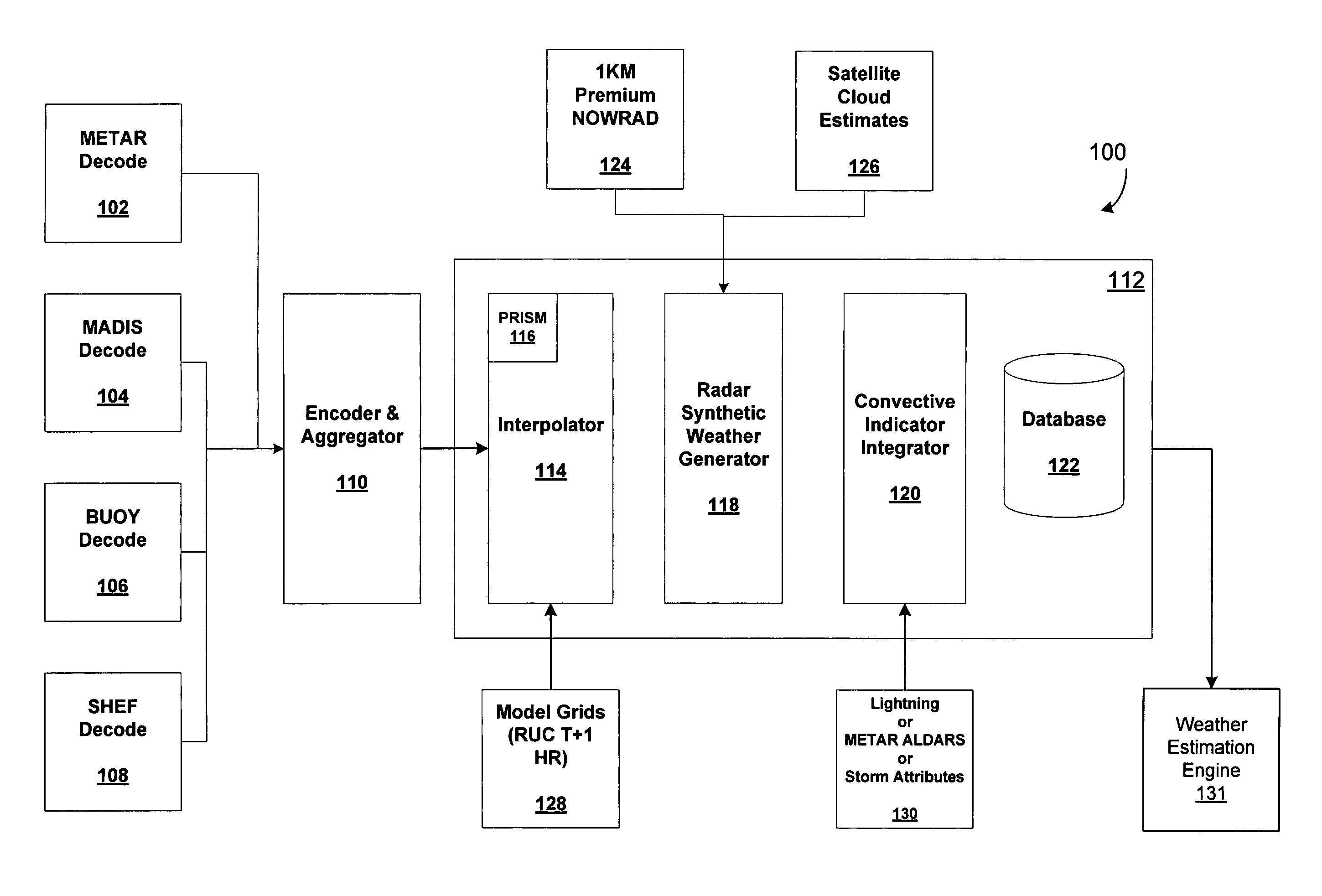
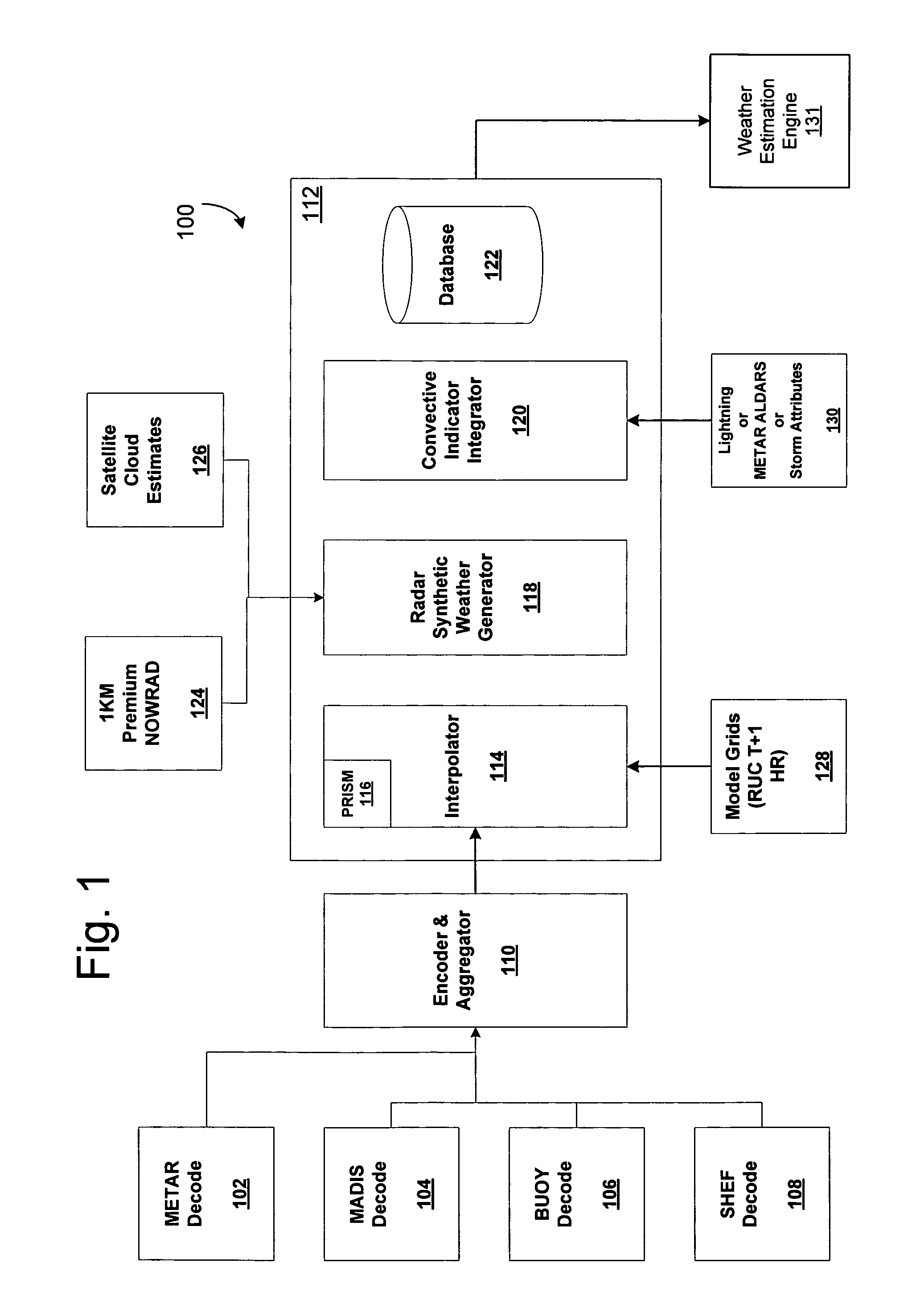
[0019]The present invention provides systems and methods for estimating observed surface weather conditions in locations between the official reporting stations. As such, the present invention may estimate the surface weather conditions of large numbers of locations, well beyond the number of official reporting stations, by zip code, place names, GPS triangulations, etc. For example, a frequent problem encountered in the current observation network arises when a point is found to be experiencing “Light Rain,” and a nearby point is simultaneously experiencing “Light Snow.” Conventionally, there is no practical way to directly estimate the weather found between these two points. The present invention overcomes this limitation by interpolating conditions to points with unknown values that lie between the known points. The new interpolated values can be used to produce the discrete enumerated weather condition inputs for these intermediate locations.

[0020]Referring to FIG. 1, there is i...


PUM


Abstract

Methods and articles of manufacture for estimating or deriving weather observations/conditions for any given location using observed weather conditions from neighboring locations, radar data, lightning data, satellite imagery, etc. An initial estimate of weather conditions for a location is made based on a downscaling process using the current conditions the neighboring locations. A measure of corroboration between the radar data and surface weather conditions at official observing stations may be established. Through the results of the downscaling process, radar calibration statistics and estimates of ground-based precipitation, the corroboration can be iteratively tuned, resulting in a weather conditions vector containing associated meteorological fields for locations that lie between or near the sparse network of official observing sites from which an estimate of the weather conditions may be made.

Description

FIELD OF THE INVENTION[0001]The present invention relates to weather data or content analysis. In particular, the present invention is directed to a system and method of utilizing observed weather data, radar and / or satellite imagery to provide an indication of surface weather conditions for any selected point or ground-based point.BACKGROUND OF THE INVENTION[0002]In the United States, the commercial weather sector provides forecasts, observations, and other meteorological content to businesses and consumers for direct fees and other forms of compensation. There is, at any time, a strong drive for value-added differentiation in this sector, since most of the basic weather forecast and observational data originates from a freely available, public data source—the National Weather Service (NWS).[0003]Weather information vendors attempt to add value to the basic, public-domain database in many ways to distinguish themselves over other vendors. One area in which value-added products and ...

Claims


Application Information

Patent Timeline
IPC IPC(8): G06F19/00
CPCG01W1/10G01W1/02Y02A90/10
Inventor ROSE, JR., BRUCE L.MILLER, IAN JAMESNEILLEY, PETER PAULLIDRBAUCH, JAMES J.FACIANE, DAVID RICHARDKLEIST, MICHAEL R.
Owner DTN LLC
Why Eureka
Try Eureka