Automatic weather radar system and method

a weather radar and automatic technology, applied in the field of airborne weather radar systems and methods, can solve the problems of difficult identification, adversely affecting the passing of aircraft, reducing the background image of terrain related, etc., and achieves the effect of removing ground clutter, weaker echo intensity color, and stronger echo intensity

Inactive Publication Date: 2007-04-17
HONEYWELL INT INC
View PDF42 Cites 69 Cited by
  • Summary
  • Abstract
  • Description
  • Claims
  • Application Information

AI Technical Summary

Benefits of technology

[0005]A radar system apparatus is provided, adapted to display thunderstorm images to a pilot, substantially free of interfering ground clutter. The apparatus comprises an antenna, a radar transmitter / receiver (T / R) coupled to the antenna wherein the T / R and antenna generate an outgoing radar beam and receive returning radar echoes of the thunderstorm, an antenna steering control (ASC) coupled to the antenna for steering the radar beam, a processor coupled to the T / R and ASC for managing the T / R and ASC to direct the radar beam in particular directions in space, an aircraft flight data system (AFDS) coupled to the processor for providing flight parameter information to the processor, a memory coupled to the processor for storing operating instructions for the processor and for storing a data matrix of returning radar echo intensity received from particular azimuthal (X), elevation (Y) and range (R) coordinates in space, a display coupled to the processor for receiving from the processor a modified storm image for presentation to the pilot, and, optionally, a pilot operable control input coupled to the processor through which the pilot may initiate generation and presentation of a storm image on the display and alter the range settings. The processor manages the T / R, ASC and antenna in accordance with instructions and parameters stored in the memory depending upon current flight parameters (e.g., altitude) provided by the AFDS. For aircraft altitudes at or below a predetermined value (the “datum”), the beam-shaped radar signal is directed at the storm at an angle and range setting that permits detection of the storm substantially free of ground clutter. For aircraft altitudes above the predetermined datum, two or more scans are provided: (a) a first higher altitude (e.g., higher or upper beam tilt angle) scan to locate an upper portion of the thunderstorm referred to as the storm head substantially free of ground clutter, and (b) a second lower altitude (e.g., lower or lower beam tilt angle) scan to detect the storm body, especially the bright band region of the thunderstorm, along with unavoidable ground clutter. The processor then determines the perimeter of the storm head from the first scan and uses it to form a storm image mask stored in memory. In a preferred implementation, the processor expands this storm image mask by a predetermined amount. The storm image mask is then applied to the return echo data of the second scan to prune away echoes that lie laterally outside the storm image mask, thereby substantially removing the ground clutter. The resulting modified, de-cluttered, thunderstorm radar image is presented to the pilot via the display. In a further embodiment, the processor colorizes the de-cluttered storm image so that a central region color indicates strong storm echoes and a peripheral region color adjacent the perimeter of the thunderstorm indicates weak storm echoes. Once launched, the system operates automatically without pilot intervention other than optional changes in range setting that may be performed by the pilot.
[0006]A method is provided for operating a radar system to present a thunderstorm image to a pilot. The method comprises, determining at least the aircraft altitude, then for altitudes in a first range (e.g., at or below the datum) using one or more radar beam scans at a predetermined beam elevation angle(s) to detect the storm substantially free of ground clutter and present the resulting storm image to the pilot, and for altitudes in a second range above the first range (e.g., above the datum) making at least two radar beam scans, a first scan at a first tilt angle to identify an upper portion of the storm (the storm head) substantially free of ground clutter, and a second scan at a second, lower tilt angle, to record an image of the storm and surrounding ground clutter (the storm body image), and then from the first scan determining a storm head image mask based upon the lateral extent of the storm head, then projecting that storm head image mask onto the storm body image obtained in the second scan and discarding storm body image echoes outside the storm head image mask, and then presenting the resulting modified thunderstorm image to the pilot. In a further embodiment, the perimeter of the storm head image mask is enlarged by a predetermined amount prior to being projected onto the storm body image. In a further embodiment, the predetermined amount of expansion is in the range of 5–15% of the lateral dimensions of the storm head. In a still further embodiment, the modified storm image intensity is graded on the outer 5–25% of the thunderstorm image area (the peripheral region) so as to show weaker echo intensity color in the peripheral region and stronger echo intensity color in the central region of the thunderstorm. Any residual clutter from especially prominent ground features may also be removed.

Problems solved by technology

They often produce internal lightening bolts and heavy turbulence, which can adversely affect aircraft passing through them.
Several problems that can arise in connection with airborne weather radar systems are: (i) minimizing pilot involvement in detecting the presence of thunderstorms in the flight path, (ii) determining thunderstorm location and shape relative to the aircraft, (iii) presenting the thunderstorm image on the radar display in such manner that it is easy for the pilot to grasp its location, size and relative impact on aircraft operations, and (iv) reducing the terrain related background images (collectively referred to as “ground clutter”) that can sometimes accompany thunderstorm images making them difficult to identify.

Method used


Image

  • Automatic weather radar system and method
  • Automatic weather radar system and method
  • Automatic weather radar system and method

Examples


Embodiment Construction

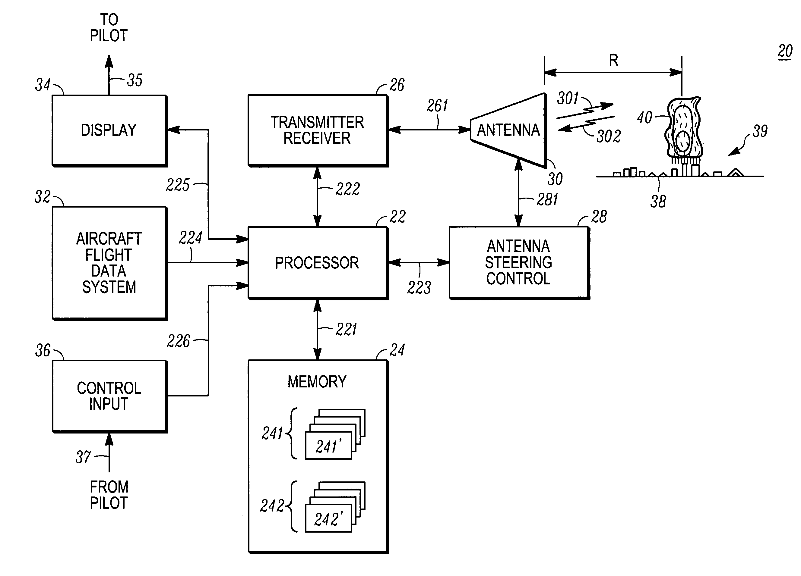
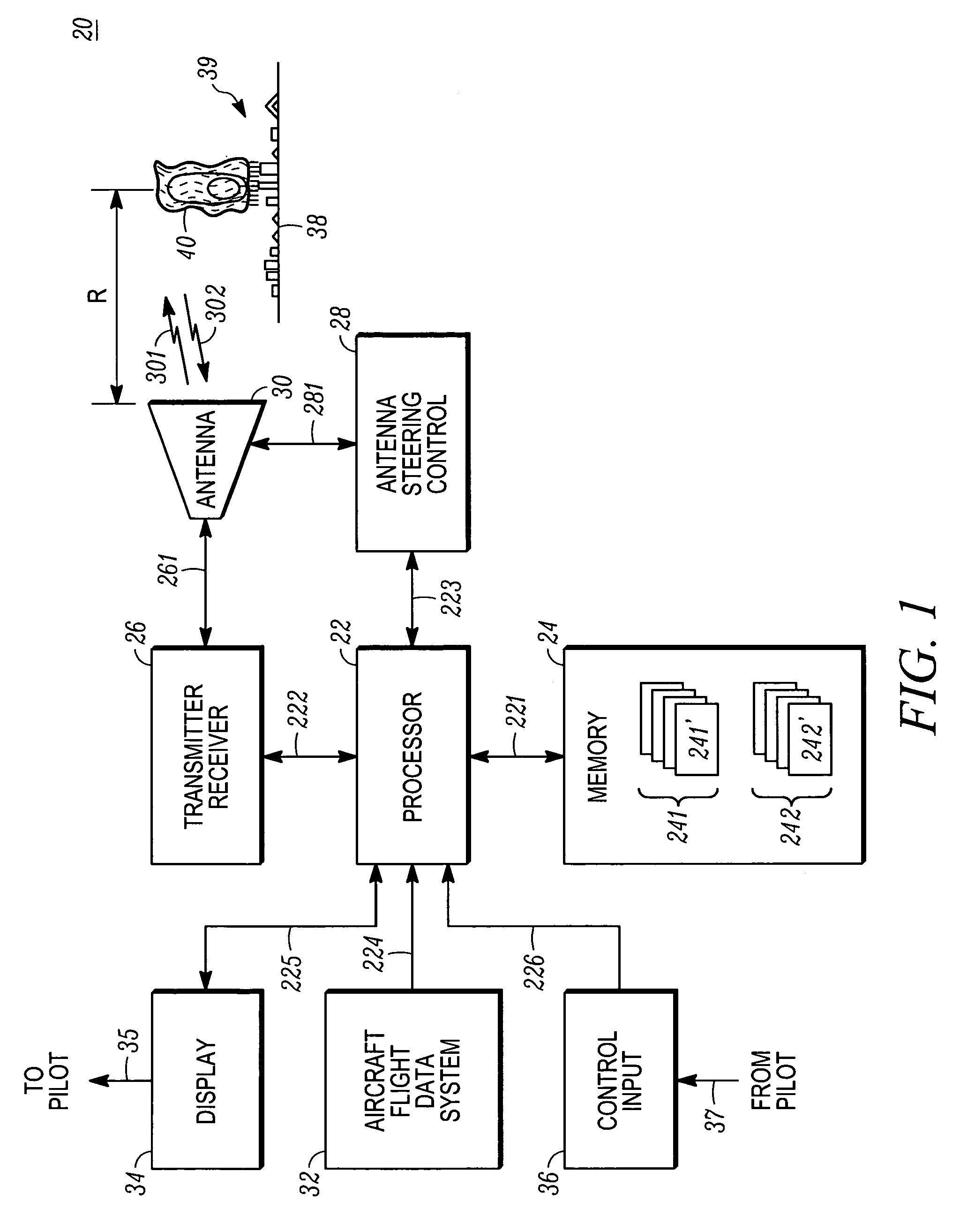
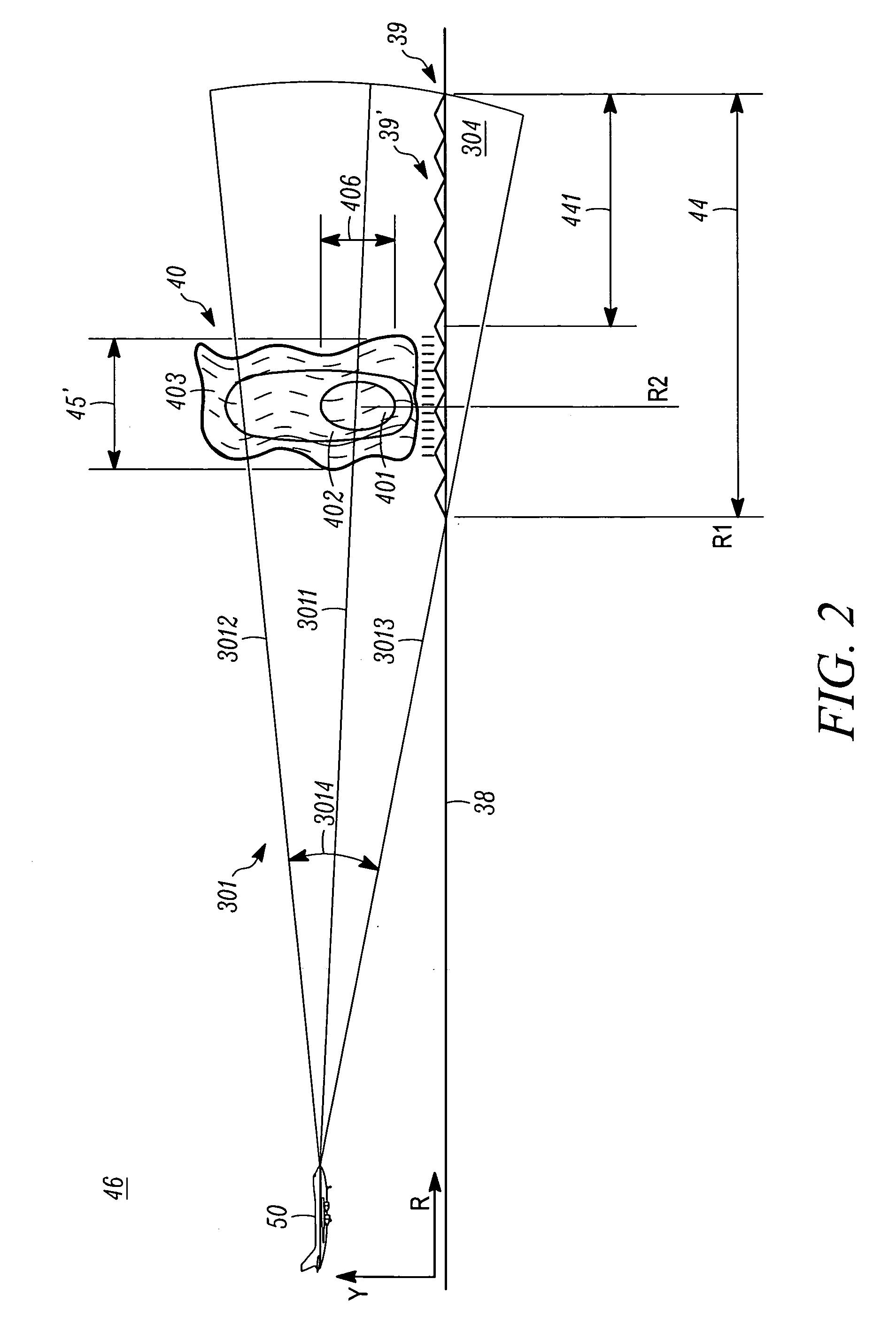
[0017]The following detailed description is merely exemplary in nature and is not intended to limit the invention or the application and uses of the invention. Furthermore, there is no intention to be bound by any expressed or implied theory presented in the preceding technical field, background, brief summary or the following detailed description.

[0018]For simplicity and clarity of illustration, the drawing figures illustrate the general manner of construction and method of operation, and descriptions and details of well-known features and techniques may be omitted to avoid unnecessarily obscuring the invention. Additionally, elements in the drawings figures are not necessarily drawn to scale. For example, the dimensions of some of the elements or regions in the figures may be exaggerated relative to other elements or regions to help improve understanding of embodiments of the invention.

[0019]The terms “first,”“second,”“third,”“fourth” and the like in the description and the claims...


PUM


Abstract

Methods and apparatus are provided for operating a radar system to provide a thunderstorm image to a pilot. The method comprises using one or more radar scans depending upon the aircraft altitude, a single upward tilted scan at or below a datum level of about 15,000±3000 feet wherein a clutter free storm image may be obtained and two scans above the datum level; a first upward tilting scan to determine, clutter free, a storm head perimeter and a second lower tilting scan for the storm body with ground clutter. The perimeter is used to discard return echoes from the second scan that lie outside the perimeter or an expansion thereof and retain those lying on or within the perimeter. The result is presented to the pilot. Optionally, the thunderstorm image is graded from center to edge so as to indicate weaker echo intensity near the edge.

Description

TECHNICAL FIELD[0001]The present invention generally relates to airborne radar systems and methods, and more particularly relates to airborne weather radar systems and methods.BACKGROUND[0002]Airborne radar systems are widely used to assist pilots in avoiding obstacles and unfavorable weather ahead of the aircraft. For convenience of description, the term “pilot” is intended to include any person who is operating and / or viewing the radar images and not merely the person who is controlling the aircraft and the terms “storm” or “storms” are intended to include any type of weather disturbance detectable by the radar but especially thunder storms. As used herein, the term “thunderstorms,” whether singular or plural, is intended to refer to cumulonimbus storms. These are convective storms that have significant moisture content. Such storms usually involve rapidly rising and sometimes violent columns of moisture ladened air that can extend to high altitudes. Typical thunderstorms are ofte...

Claims


Application Information

Patent Timeline
Patent Type & Authority Patents(United States)
IPC IPC(8): G01S13/95G01S13/00G01S13/08
CPCG01S13/953G01S7/414Y02A90/10
Inventor SWEET, STEVEN R.
Owner HONEYWELL INT INC
Why Eureka
Try Eureka