Navigation system for a snorkeler

a navigation system and snorkeling technology, applied in underwater equipment, instruments, measurement devices, etc., can solve the problems of poor navigation skills, poor navigation skills, and a much higher chance of missing most of them

Inactive Publication Date: 2007-12-18
BROWN RICHARD IVAN
View PDF12 Cites 23 Cited by
  • Summary
  • Abstract
  • Description
  • Claims
  • Application Information

AI Technical Summary

Benefits of technology

[0027]The present invention thus provides the snorkeler with a system that can provide needed navigational information that includes, but is not limited to, distance and direction to a predetermined location; current location and velocity; and / or graphical representation of the snorkeler's position on a map.

Problems solved by technology

With luck, they might happen upon a good area, but are much more likely to miss most of them entirely.
Even with fairly good directions they may still miss their destination due to less than ideal visibility, poor navigation skills, or both.
However, marking an underwater trail is expensive and difficult to do without taking away the natural beauty of the site.
Additional expense and complication arise when maintenance issues develop.
And placing permanent markers on a coral reef raises significant environmental issues.
Another problem can arise when a snorkeler ventures into a shallow area where an environmental fragile entity exists, such as a coral bed or delicate sea anemone.
In such tight quarters it is easy to contact the entity, causing damage to it and, perhaps, to the snorkeler.
Yet another problem a snorkeler might encounter is that of finding his way back to a given starting point or to some other predetermined exit point.
The problem is compounded if the weather suddenly turns inclement.
Even if the weather remains mild, waves can obscure details of the shoreline, again making it difficult to find the correct exit point.
Even snorkelers who swim from excursion boats can't completely avoid the problem because there are frequently many excursion boats all looking approximately alike at the same site.
Still another problem that a resort snorkeler encounters is that of time management.
It is difficult enough to meet that kind of time commitment even if he knows what time it is, yet many resort snorkelers don't have watches that can be used underwater.
Thus snorkelers, and especially inexperienced snorkelers, face a number of issues they aren't aware of when the they start.
They may stumble into areas that are environmentally fragile or unsafe to swim into.
All of these problems become even more daunting if inclement weather suddenly arises, even for experienced snorkelers.
But towing a float is an encumbrance for a snorkeler, especially an inexperienced one, because the towline is distracting, occupies one hand, presents a constant drag, and frequently becomes entangled in his arms, legs, and fins.
Still another issue with the above system that makes it less desirable for use by a snorkeler is that the navigational information computed by the system is that for the float, not the scuba diver.
In particular, the location and direction of travel of the float is not necessarily that of the scuba diver because the float is at the end of a long towline and is thus slow to respond to a change in direction by the scuba diver.

Method used


Image

  • Navigation system for a snorkeler
  • Navigation system for a snorkeler

Examples


Embodiment Construction

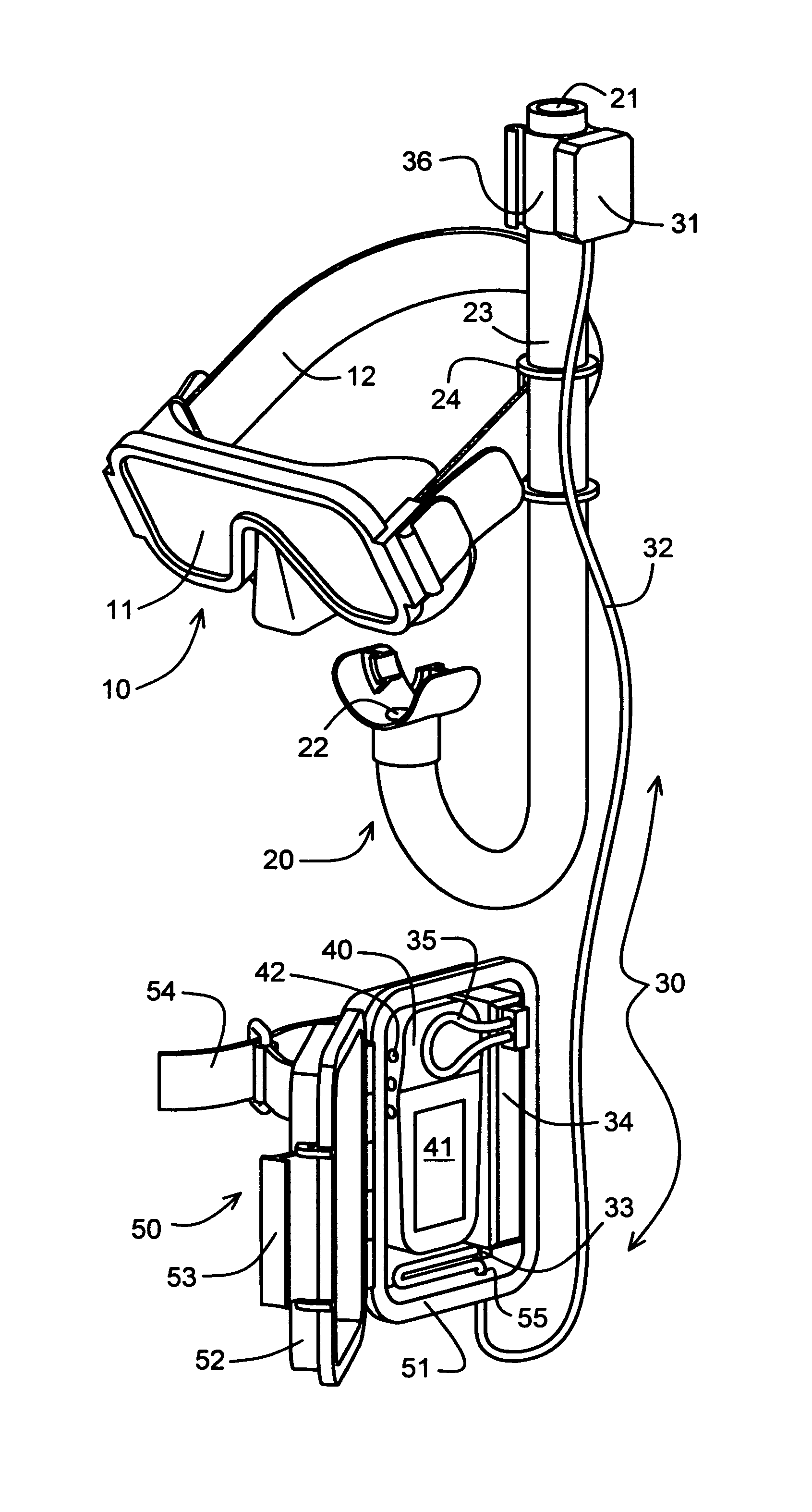
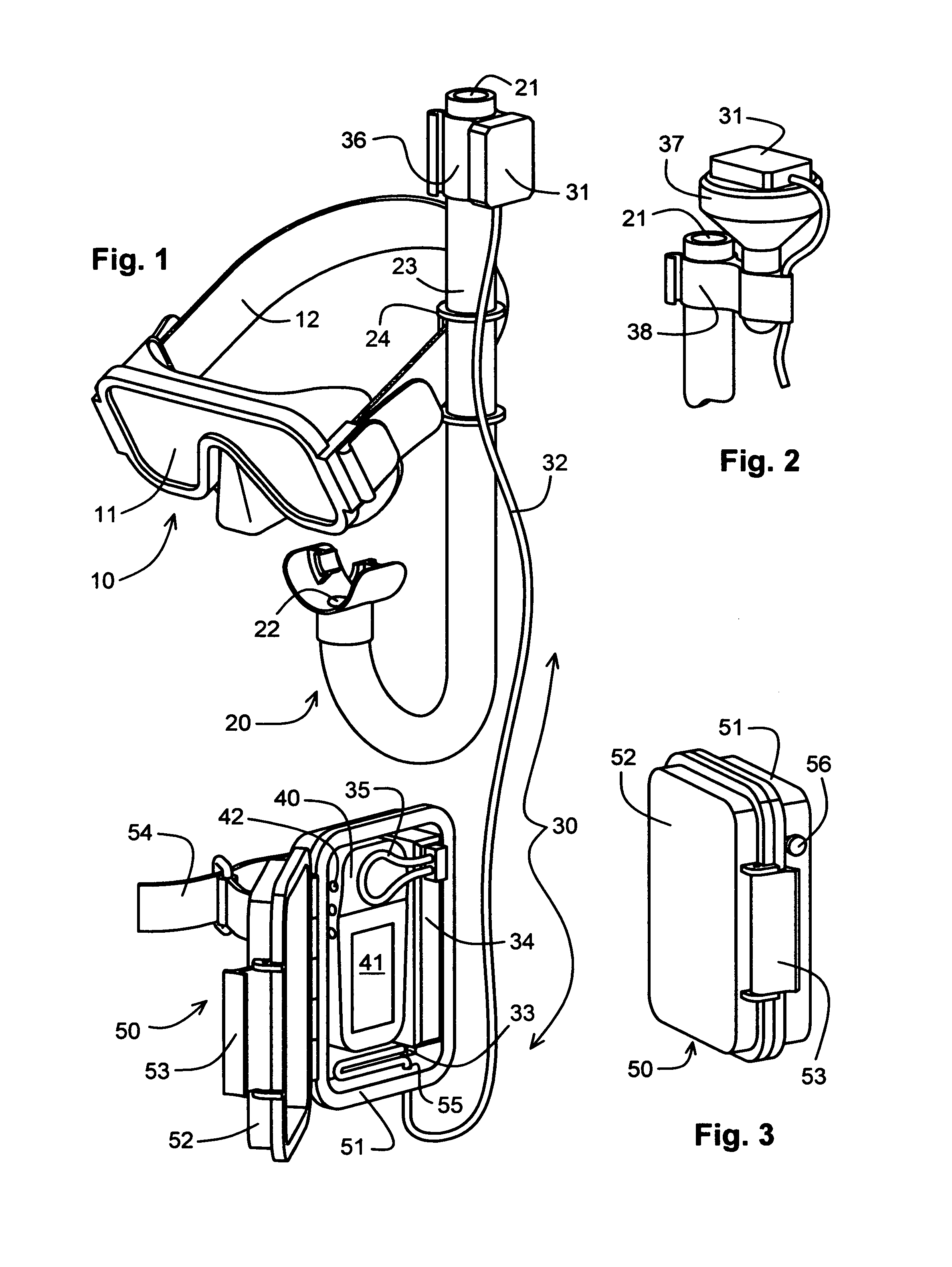
[0032]The illustrative embodiment is shown in FIG. 1 and comprises mask 10, snorkel 20, GPS re-radiator assembly 30, handheld GPS receiver 40, and waterproof case 50. Masks and snorkels are known in the art and shown in only generic form. GPS re-radiator assemblies are also known in the art and typically comprise a receiving antenna, a power source, a signal amplifier and a re-transmitting antenna. Handheld GPS receivers are also known in the art and are marketed by a number of manufactures. Typically, they include an internal GPS signal receiving antenna, a GPS signal and data processor, and a display for presenting navigational information to the user. The type and form of the navigational information presented varies from manufacturer to manufacturer, but most have several user selectable screens to present a graphical map, a compass, and numerical data. They have become so ubiquitous that a detailed explanation of their workings, controls, and graphical displays is not necessary...


PUM


Abstract

A navigation system is provided for use by a snorkeler. A GPS signal receiving antenna (31) is coupled to the snorkeler in a substantially fixed spatial relationship and communicates with a display (41) to provide the snorkeler with navigational information. In the illustrative embodiment, the GPS signal receiving antenna (31) is attached to the breathing tube (23) of the diver's snorkel (20) and communicates with the display (41) of a handheld GPS receiver (40) housed in a waterproof case (50). The GPS signals received by the GPS signal receiving antenna (31) are conveyed to the handheld GPS receiver (40) via a GPS re-transmitting antenna (35) housed in the same waterproof case (50). An externally operable pushbutton (56) allows the snorkeler to switch between multiple screens presented on the display (41) to guide him through the snorkeling site.

Description

FIELD OF THE INVENTION[0001]The invention relates to the field of navigation, and, more specifically, to a global positioning system (GPS) based navigation system for snorkelers.BACKGROUND OF THE INVENTION[0002]The present invention provides a GPS based navigation system for use by a swimmer while snorkeling. One would not expect that a snorkeler would need a sophisticated navigation system since all he has to do is raise his head and look around to acquire whatever visual points of reference he might need to find his way around a snorkeling site. Surprisingly, however, providing the snorkeler with a navigation system greatly increases his safety and enjoyment, can have a positive effect on the environment, and can improve the health of the coral reef system as discussed below.[0003]Snorkeling has become increasingly popular among tourists at resorts and parks, and as side excursions on cruises. Most tourists have limited or no snorkeling experience. After donning mask, snorkel and ...

Claims


Application Information

Patent Timeline
Patent Type & Authority Patents(United States)
IPC IPC(8): G01S1/00G01S19/14B63C11/16G01S19/19G01S19/35
CPCB63C11/205B63C11/26G01S19/35G01S19/19G01C21/20
Inventor BROWN, RICHARD IVAN
Owner BROWN RICHARD IVAN
Why Eureka
Try Eureka