Mapping application for rendering pixel imagery

a mapping application and imagery technology, applied in the field of mapping applications, can solve the problems of limited processing power, memory and display size, limited frame-rate, and drawing tricks used to temporarily disorient users

Active Publication Date: 2008-05-27
RAYTHEON CO
View PDF28 Cites 15 Cited by
  • Summary
  • Abstract
  • Description
  • Claims
  • Application Information

AI Technical Summary

Benefits of technology

[0009]The present invention provides a mapping application for rendering pixel imagery on platform with limited processing power, memory and display size. The mapping tool provides the capability to navigate multiple images simultaneous, the ability to pan, scan, zoom and rotate in near real-time, and enables “track-up” mode.
[0012]In another embodiment, the execution time to perform the affine transformation is, on average over all rotations of the view port in world space, greatly improved by storing the map pixel data in vertical strips of memory. On average, this will greatly reduce the likelihood of a cache miss when rendering the maps. In this case pixel data is sampled by determining the vertical strip in memory in which the pixel data resides, converting the map space coordinate into a vertical strip column coordinate, and sampling the pixel data from the vertical strip at the column coordinate.
[0015]To further improve processing efficiency, the processor preferably executes the mapping application using integer fixed-point math whenever possible, writes and reads pixel data in double words, and constructs an entire graphics frame in an off-screen double-buffer and then paints the entire frame to the view port at once.

Problems solved by technology

These requirements have to be implemented on a battery-powered handheld device with limited processing power, memory and display size.
However, their frame-rate is limited by the need to redraw all of the line segments on-screen every time the view of the map is changed.
However, some of the drawing tricks employed can have the effect of temporarily disorienting the user when they are rapidly panning or zooming.
Most of these applications do not support rotation.
However, on a platform such as a PDA having limited memory and processing power, the supported frame rate is very slow, a slide show at best.
These applications use rendering algorithms that are more efficient at panning than zooming, so they typically limit zoom capability to a “step” zoom between a few constant defined zoom levels so that the slow update rate is less noticeable.
This can have the effect of temporarily disorienting the user when “jumping” from one zoom level to the other.
In addition, rotating picture maps is a feature that is completely unsupported by any existing PDA mapping tools.

Method used


Image

  • Mapping application for rendering pixel imagery
  • Mapping application for rendering pixel imagery
  • Mapping application for rendering pixel imagery

Examples


Embodiment Construction

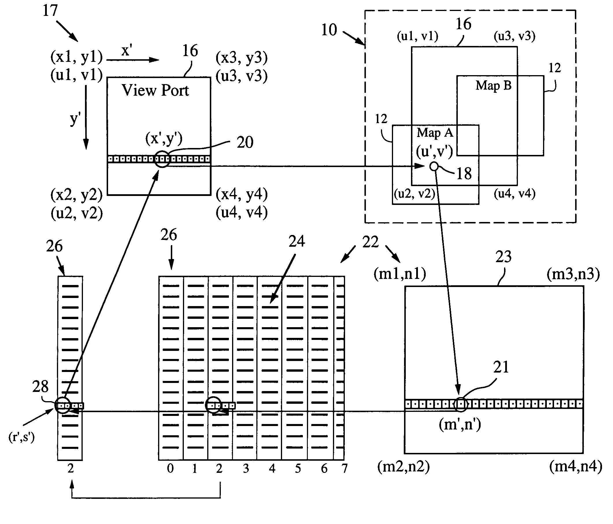
[0026]The present invention relies on a modified affine transformation algorithm to provide near real-time navigation of imagery, track-up capability and integration of segment and picture data. The mapping application is most useful for rendering pixel imagery on a platform with limited processing power, limited memory and small display sizes, e.g., “hand held devices” such as a GPS handset, a personal digital assistant (PDA) or cell phone. However, the techniques could be applied to other platforms such as car navigation systems, laptop computers or PCs.

[0027]Affine transformations are algorithms most often used in 3D graphics for texturing polygons (triangles are most commonly used) with bitmaps. They are also used in applications that allow the rotation of 2D images, such as Power Point®. Although the affine transformation algorithm is known, its use in and modification for a map rendering application is new. The standard affine algorithm, although adequate for displaying a sing...


PUM


Abstract

A mapping application relies on a modified affine transformation algorithm to provide near real-time navigation of imagery, track-up capability and integration of segment and picture data. The affine transformation is modified to map a “world space” comprised of a plurality of pixel maps onto a view port. The pixel data for the maps is preferably stored in vertical strips of memory to reduce the likelihood of cache misses. The mapping application is most useful for rendering pixel imagery on a platform with limited processing power, limited memory and small display sizes, e.g., “hand held devices” such as a GPS handset, or Pocket PC.

Description

BACKGROUND OF THE INVENTION[0001]1. Field of the Invention[0002]This invention relates to mapping applications, and more specifically to a mapping application for rendering pixel imagery on platforms with limited processing power and memory and small display sizes.[0003]2. Description of the Related Art[0004]Hand held devices are rapidly evolving beyond their use as an address book, calendar, note pad, etc. They are merging with other technologies to provide cellular telephone service, email, wireless internet and other applications. Continuing improvements in processor speed, memory, displays and battery power are making the hand held devices a powerful and ubiquitous tool for consumers, business, and the military.[0005]Mapping applications allow users to display and navigate maps on a hand held display using GPS technology. Mapping application software should support the ability to pan around a map, zoom in and out, manipulate navigation objects, and view a tracked position relati...

Claims


Application Information

Patent Timeline
Patent Type & Authority Patents(United States)
IPC IPC(8): G06T15/10G09G5/00
CPCG06T3/0006G06T17/05
Inventor HOFF, CHRISTOPHER G.
Owner RAYTHEON CO
Why Eureka
Try Eureka