Method for optimization of temporal and spatial data processing

a technology for spatial data and optimization, applied in data processing applications, instruments, geographical information databases, etc., can solve the problems of large loss of temporal functionality, time-consuming domain translation, sql conversion, etc., and achieve the effect of improving temporal/spatial data processing

Inactive Publication Date: 2008-12-30
IBM CORP
View PDF22 Cites 23 Cited by
  • Summary
  • Abstract
  • Description
  • Claims
  • Application Information

AI Technical Summary

Benefits of technology

[0021]Provided are a method, system, and program for processing temporal data. A spatial query is received specifying a mapping function that identifies a set of temporal values for one or more objects. Geographic positions are automatically extracted from each set of temporal values for ea

Problems solved by technology

In addition, the majority of temporal functionality may be lost in the first SQL conversion 114.
This doma

Method used


Image

  • Method for optimization of temporal and spatial data processing
  • Method for optimization of temporal and spatial data processing
  • Method for optimization of temporal and spatial data processing

Examples


Embodiment Construction

[0030]In the following description, reference is made to the accompanying drawings which form a part hereof and which illustrate several implementations of the present invention. It is understood that other implementations may be utilized and structural and operational changes may be made without departing from the scope of the present invention.

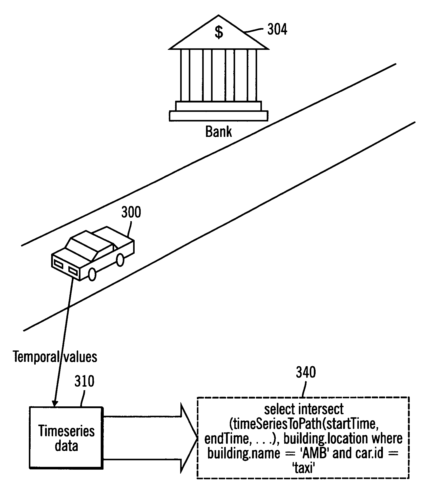
[0031]Implementations of the invention provide functions that move data from the temporal to spatial domain directly, thereby reducing the lag between collecting and using the data, as well as, eliminating redundancies.

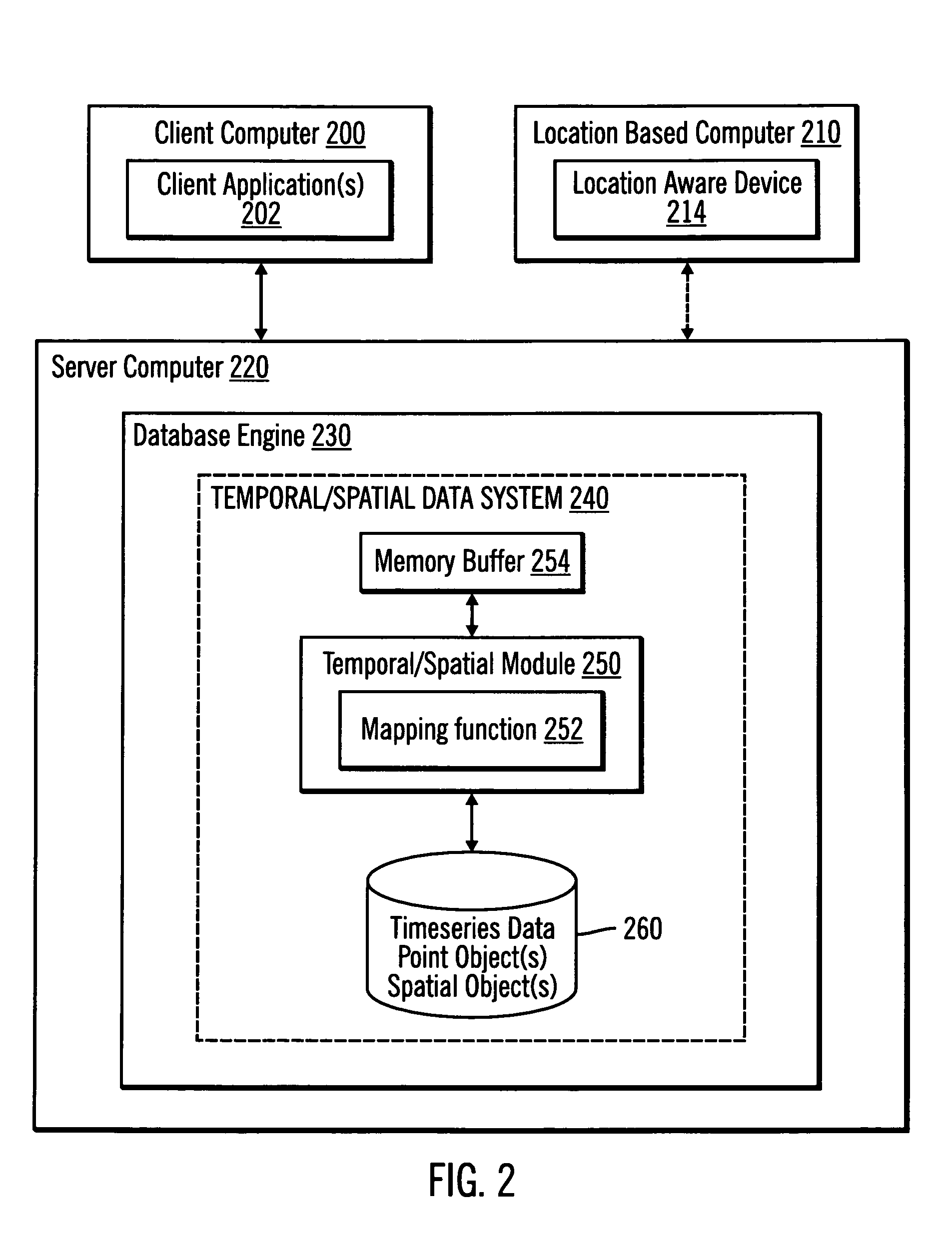
[0032]FIG. 2 illustrates, in a block diagram, a computing environment in accordance with certain implementations of the invention. A client computer 200 executes one or more client applications 202. A client application 110 may be any type of application program.

[0033]A location based computer 210 includes a location aware device 214, such as a GPS receiver. The location aware device 214 is capable of generating temporal value...


PUM


Abstract

Disclosed is a method for processing temporal data. A spatial query is received specifying a mapping function that identifies a set of temporal values for one or more objects. Geographic positions are automatically extracted from each set of temporal values for each of the one or more objects. Point objects are generated from the geographic positions. One or more spatial objects are generated from the point objects.

Description

BACKGROUND OF THE INVENTION[0001]1. Field of the Invention[0002]The present invention is related to temporal and spatial data processing.[0003]2. Description of the Related Art[0004]The Global Positioning System is a set of satellites that orbit the earth and make it possible for people with ground GPS receivers to pinpoint their geographic location. The GPS is owned and operated by the U.S. Department of Defense but is available for general use around the world.[0005]At any given time, four satellites from the set of satellites are above the horizon. Each satellite contains a computer, an atomic clock, and a radio. Each satellite has an understanding of its orbit and has a clock. With this, each satellite continually broadcasts its changing position and time. On the ground, each GPS receiver contains a computer that “triangulates” its position by getting bearings from three of the four satellites. The result is a geographic position in the form of a longitude and latitude.[0006]As ...

Claims


Application Information

Patent Timeline
IPC IPC(8): G06F17/30
CPCG06F17/30241G06F17/30551Y10S707/99944Y10S707/99933G06F16/29G06F16/2477
Inventor KATIBAH, EDWINSIEGENTHALER, MARTIN
Owner IBM CORP
Why Eureka
Try Eureka