LEO-based positioning system for indoor and stand-alone navigation

a positioning system and satellite technology, applied in the field of navigation, can solve the problems of insufficient power of gps to penetrate the walls of buildings, may not be available to a navigation user, and may not be able to meet the needs of navigation users, so as to improve the integration load

Active Publication Date: 2009-02-10
THE BOEING CO
View PDF11 Cites 77 Cited by
  • Summary
  • Abstract
  • Description
  • Claims
  • Application Information

AI Technical Summary

Benefits of technology

[0008]The present invention comprises a system for leveraging the relative strengths of at least two navigation systems, an inertial navigation system and a LEO satellite navigation system. The inertial navigation system is used to ameliorate the integration load on the LEO satellite navigation processing system and the inertial system provides a good approximation of the changing position of the user device where jamming or an indoor environment blocks the use of the LEO satellite navigation. In turn, the LEO satellite navigation system will provide a precise position location to refine the inertial position fix wherever a precise position is available.
[0011]In accordance with yet another aspect of the invention, the advantageously rapid changing geometry of the LEO satellites allows rapid convergence of a positional fix.
[0012]In accordance with preferred embodiments of the present invention, a Low Earth Orbiting (LEO) satellite constellation, such as Iridium, is used as a ranging source operating in conjunction with MEMS inertial sensors and a precise user time standard to offer an effective and low-cost approach to navigation without using GPS. Applications of the present invention include (but are not limited to) ultra-wide-band interference protection, anti-jam protection, and enhanced ability to use GPS indoors.
[0014]In accordance with still further aspects of the invention, inertial navigation sensors significantly reduce integration time on a signal transmitting over a special Iridium broadcast channel that has no data modulation (or with schemes that emulate low modulation rates). The inertial navigation sensor removes much of the effective bound-on integration time. Integration times of several seconds would allow an extremely weak Iridium signal (that had originally been boosted 30 to 45 dB above GPS in power) to be used deep indoors or in conditions of high jamming.
[0015]In accordance with other aspects of the invention, the inventive method and apparatus reduces multipath. Treating the superposition of several sub-bands as a CDMA signal rather than a TDMA signal allows the superposition to be processed by code correlators inside an Iridium receiver to estimate multipath in real time.
[0016]In accordance with other aspects of the invention, the inventive method and apparatus combines its results with those of such other satellite navigation systems as may be available or intermittently available to establish fixes to augment positioning solutions. The more ranging sources, the better. Examples of other useable satellites are Globalstar and GPS. In general, with more ranging sources, biases can be estimated more quickly, and the dependence on the inertial component can be loosened in proportion to the additional ranging data available.

Problems solved by technology

In many instances, GPS may not be available to a navigation user.
In hostile conditions, GPS may be jammed or otherwise defeated.
In indoor application, GPS has insufficient power to penetrate the walls of buildings.
However, GPS has a low-power signal that limits operations indoors or in conditions of heavy jamming.

Method used


Image

  • LEO-based positioning system for indoor and stand-alone navigation
  • LEO-based positioning system for indoor and stand-alone navigation
  • LEO-based positioning system for indoor and stand-alone navigation

Examples


Embodiment Construction

[0026]The present invention relates to satellite navigation. Many specific details of certain embodiments of the invention are set forth in the following description and in FIGS. 1 through 5 to provide a thorough understanding of such embodiments. One skilled in the art, however, will understand that the present invention may have additional embodiments, or that the present invention may be practiced without several of the details described in the following description.

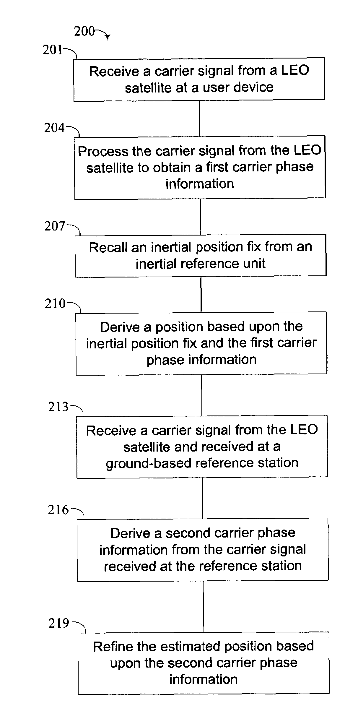
[0027]By way of overview, a method for estimating a precise position of a user device from signals from a low earth orbit (LEO) satellite includes receiving at least one carrier signal at a user device, each carrier signal being transmitted a distinct LEO satellite. The user device processes the carrier signals to obtain a first carrier phase information. The user device recalls an inertial position fix derived at an inertial reference unit. The user device derives a position of the user device based on the inertial p...


PUM


Abstract

A method for estimating a precise position of a user device from signals from a low earth orbit (LEO) satellite includes receiving at least one carrier signal at a user device, each carrier signal being transmitted a distinct LEO satellite. The user device processes the carrier signals to obtain a first carrier phase information. The user device recalls an inertial position fix derived at an inertial reference unit. The user device derives a position of the user device based on the inertial position fix and the first carrier phase information.

Description

RELATED APPLICATIONS[0001]This application claims priority from a provisional application Ser. No. 60 / 536,823 filed on Jan. 15, 2004 and entitled, “LEO-BASED POSITIONING SYSTEM FOR INDOOR AND STAND-ALONE NAVIGATION.” That application is incorporated by this reference.FIELD OF THE INVENTION[0002]This invention relates generally to systems for navigation and, more specifically, to using LEO satellites for navigation.BACKGROUND OF THE INVENTION[0003]In many instances, GPS may not be available to a navigation user. In hostile conditions, GPS may be jammed or otherwise defeated. In indoor application, GPS has insufficient power to penetrate the walls of buildings.[0004]GPS now provides at least four ranging sources simultaneously which enables instantaneous, three-dimensional positioning. However, GPS has a low-power signal that limits operations indoors or in conditions of heavy jamming. A fundamental advantage of the system described herein is that it simultaneously addresses the limit...

Claims


Application Information

Patent Timeline
Patent Type & Authority Patents(United States)
IPC IPC(8): H04W4/00G01S19/11G01S5/02G01S5/14H04B7/185
CPCG01S5/0263G01S19/26G01S19/423
Inventor WHELAN, DAVID A.COHEN, CLARK E.GUTT, GREG M.FERRELL, BARTON G.
Owner THE BOEING CO
Why Eureka
Try Eureka