System and method of displaying map image

a map image and display system technology, applied in the field of system and method of displaying map image, can solve the problems of losing sight of a target position on the map image, the inability to smoothly change the map image, etc., and achieve the effect of smooth movement of the display range of the one-page map image, short time, and easy checking of the continuity of the map imag

Inactive Publication Date: 2009-09-01
PIONEER CORP +1
View PDF33 Cites 24 Cited by
  • Summary
  • Abstract
  • Description
  • Claims
  • Application Information

AI Technical Summary

Benefits of technology

[0022]Hence, when a center point of the display range of the one-page map image designated on the user terminal screen is moved, the system allows the user terminal to re-display a new one-page map image with a changed center point simply by the reception, from the map database site, of a unit or units of map data required for displaying a map image or map images corresponding to the newly added sections of the display range of the one-page

Problems solved by technology

Hence, the conventional system has the problem of the impossibility of smoothly changing map images because of the long time lag until a new map image is displayed.
Further, for the reason that a map image displayed in a map-image display frame F in a web page is generated from an in

Method used


Image

  • System and method of displaying map image
  • System and method of displaying map image
  • System and method of displaying map image

Examples


Embodiment Construction

[0080]One of preferred embodiments according to the present invention will be described hereinafter in detail with reference to the accompanying drawings.

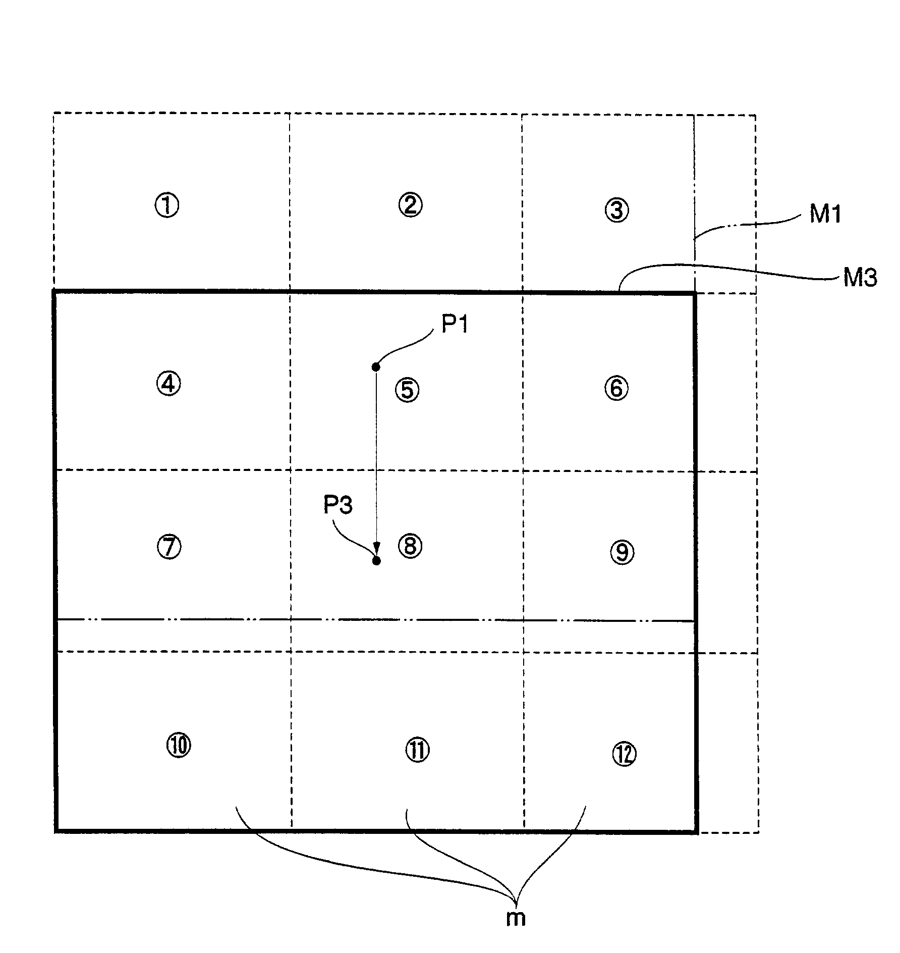
[0081]FIG. 1 is a schematic representation illustrating a computer network comprising a map database site S and user terminals T which are connected through the Internet I in the preferred embodiment of a system of displaying map images according to the present invention.

[0082]In FIG. 1, the map database site S performs the service of providing map data for allowing the user terminal T to display a map image in response to a request transmitted from the user terminal T through the Internet, and includes a map delivery server Sa and a map information database Sb for accumulating map data for delivery.

[0083]The map delivery server Sa of the map database site S includes a retrieval CGI (Common Gateway Interface) for searching the map database Sb for map data corresponding to input information, e.g. place names, addresses, rail-station...


PUM


Abstract

A map database site S comprises a map information database Sb for accumulating the map data constructed of units for displaying of unit images m each having a display range smaller than a display range of a map image M corresponding to one page of a map image displayed on a user terminal T, in association with position data indicating the display ranges of the individual unit images m. A user terminal T comprises map-image display means for combining the map data of a plurality of units with each other on the basis of the associated position data, which are read out from the map information database Sb provided in the map database site S and transmitted from the map database site S, to form the one-page map image M for display.

Description

BACKGROUND OF THE INVENTION[0001]1. Field of the Invention[0002]This invention relates to a system of providing map data accumulated in a server through a computer network to a user terminal for the display of a map image, and a method of displaying the map image.[0003]The present application claims priority from Japanese Application No. 2001-255159, the disclosure of which is incorporated herein by reference for all purposes.[0004]2. Description of the Related Art[0005]Information providing services of providing various types of information through a computer network such as the Internet include a map-information providing service for providing map data accumulated in a server through the computer network to a user terminal connected to the computer network as required, to allow the user terminal to display a desired map image.[0006]FIG. 6 illustrates an example of map images displayed on the user terminal on the basis of map data provided by the map-information providing service a...

Claims


Application Information

Patent Timeline
IPC IPC(8): G06F3/00G06F3/14G09B29/00G01C21/00G06F17/30G06T1/00G06T3/00G06T11/60G08G1/137
CPCG06F17/30899G09G2340/145G06F16/957Y10S707/99945Y10S707/99948
Inventor OKAMURA, JUNICHI
Owner PIONEER CORP
Why Eureka
Try Eureka