System and method for asynchronous continuous-level-of-detail texture mapping for large-scale terrain rendering

a texture mapping and large-scale technology, applied in static indicating devices, 2d-image generation, instruments, etc., can solve the problems of increasing the size of the texture, unable to be accessed as quickly by a graphics processing unit or gpu, and unable to determine the precise influence of all the texels

Inactive Publication Date: 2009-12-01
D& S CONSULTANTS
View PDF23 Cites 14 Cited by
  • Summary
  • Abstract
  • Description
  • Claims
  • Application Information

AI Technical Summary

Benefits of technology

[0030]The advantages of extending the clip-map concept to include independent clip-map levels include, but are not limited to, allowing each clip-map level to be updated independently and asynchronously, an advantageous feature not realized in prior implementations of clip-mapping, such as SGI's InfiniteReality Machine graphics hardware or methods such as the “extra-dimension clip-map,” as described in U.S. Pat. No. 7,012,614. The highest resolution clip-map level may, for instance, be updated by importing texture sub-tiles from a texture data-base into a main or graphics memory on one schedule, such as, but not limited to, every second frame or data cycle. The next highest resolution clip-map level may, however, be updated on a different schedule such as, but not limited to, every fourth frame or data cycle.

Problems solved by technology

Large textures may have to be stored in a large texture database or other storage medium, which are cheaper than texture memory, but cannot be accessed as quickly by a graphics processing unit or GPU.
The problem of increasing texture size, however, is further exacerbated in the case of mip-mapping, discussed in greater detail below, where multiple copies of a texture image at different resolutions are also stored.
A major challenge for a real-time, geo-specific terrain rendering system involving a workstation computer with a “commodity” GPU, therefore, is dealing with the large amount of data that must be processed to cover a large terrain expanse using a texture that is based on high-resolution satellite imagery.
It is, however, difficult to determine the precise influence of all the texels 22 near a particular pixel 24, and it is effectively computationally impossible to do so perfectly in real time.
Simple filtering techniques, such as picking the texel 22 at the center of the pixel 24, usually result in severe aliasing of the image, i.e., the sampling causes artifacts such as, but not limited to, straight lines or edges becoming broken or jagged.
As the pre-filtering is only done once off-line, more sophisticated, computationally expensive techniques can be used.
Implementing a large texture mip-map requires a significant amount of memory.
Although clip-mapping has advantages, its use to date has been limited to specialized hardware designed to support clip-mapping, such as the InfiniteReality Machine graphics hardware available from SGI, a Delaware Corporation, or to methods such as the “extra-dimension clip-map,” as described in U.S. Pat. No. 7,012,614.
Significantly, in both of these implementations of clip-mapping, all levels of the clip-map are updated simultaneously, which is wasteful of transfer bandwidth between the data-base containing the complete texture data-base and main system and graphics memory.
Synchronous transfer of all clip-map levels, required in both of these prior implementations of clip-mapping, is also an inefficient use of graphics memory.

Method used


Image

  • System and method for asynchronous continuous-level-of-detail texture mapping for large-scale terrain rendering
  • System and method for asynchronous continuous-level-of-detail texture mapping for large-scale terrain rendering
  • System and method for asynchronous continuous-level-of-detail texture mapping for large-scale terrain rendering

Examples


Embodiment Construction

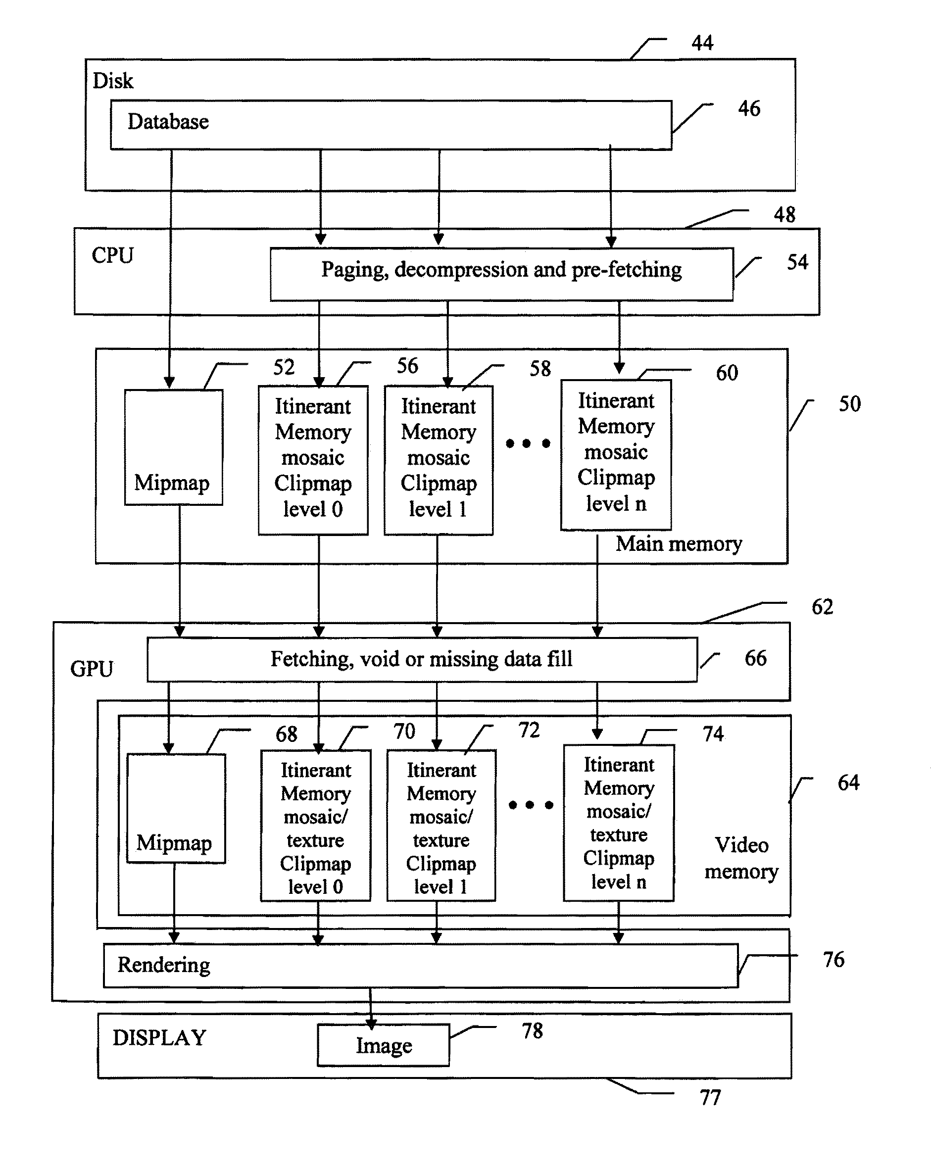
[0045]The present invention applies to systems and methods of graphics rendering, and particularly to systems and methods for real-time rendering of large, geo-specific terrains using standards based, or commodity, GPUs, graphics hardware and / or graphics hardware systems.

[0046]In a preferred embodiment, the present invention leverages the vertex and fragment processors and the vertex and fragment shaders that are now standard components of many commodity GPUs to implement an extended version of clip-mapping. Vertex shaders are programmable modules capable of modifying values associated with each vertex of a graphics geometry. Fragment or pixel shaders are programmable modules capable of modifying values on a per pixel basis. The extended clip-mapping of the present invention includes allowing asynchronous updating of the different clip-map levels. Whereas with prior clip-map technology, such as SGI's InfiniteReality Machine, the clip-maps of each clip-map level all have a common ori...


PUM


Abstract

A multi-resolution texture mapping system suitable for large scale terrain rendering using commodity graphics processing units (GPU). The GPU vertex and fragment shaders are used to implement the clip-mapping functionality. The terrain texture is represented by a combination of a mip-map and a multi-level clip-map having independent origins and off-set values. The independent clip-map levels may be independently updated. The offset values allow the origins to be associated with a reference point in a scene to be rendered. The desired clip-map level to be used to render a particular fragment may be determined using the base 2 logarithm of the maximum screen-space derivative of the source texture required by the terrain geometry to be drawn. If the desired clip-map level is non-integer and lies between two clip-map levels, appropriate texel data is created by interpolating between the bounding clip-map levels. This interpolation allows a multi-resolution texture mapping to be displayed.

Description

CROSS REFERENCE TO RELATED APPLICATIONS[0001]This application is related to, and claims priority from, U.S. Provisional Patent application No. 60 / 761,653 filed on Jan. 24, 2006, by Roger Crawfis, Frederic Kuck, Eric Noble and Eric Wagner titled “Asynchronous Continuous Level-of-Detail and Texture-Mapping for Large-Scale Terrain Rendering,” the entire contents of which are hereby incorporated by reference.FIELD OF THE INVENTION[0002]The present invention relates to systems and methods of texture mapping, and particularly, to systems and methods for asynchronous, multi-resolution texture mapping suitable for large-scale terrain rendering that are capable of being implemented on, by or with standards based or commodity graphics processing units.BACKGROUND OF THE INVENTION[0003]Many computer graphics applications such as, for example, flight simulators, need to allow users to visualize, or fly over, terrains in real time. In order to accomplish this task, applications implement various ...

Claims


Application Information

Patent Timeline
Patent Type & Authority Patents(United States)
IPC IPC(8): G09G5/00G06K9/36G06K9/54G06T11/40G06T17/20
CPCG06T17/05G06T15/04
Inventor CRAWFIS, ROGERKUCK, FREDRICKNOBLE, ERICWAGNER, ERIC
Owner D& S CONSULTANTS
Why Eureka
Try Eureka