Route calculation method for a vehicle navigation system

a vehicle navigation and route calculation technology, applied in surveying and navigation, navigation instruments, instruments, etc., can solve the problems of wasting precious bandwidth, many vehicles needing the same information, and the known methods for providing and utilizing the above-described traffic information for navigation remain inflexible, cumbersome, etc., to reduce zig-zagging of the calculated route, increase the route calculation, increase or decrease the broadcast of traffic information

Active Publication Date: 2010-03-16
HONDA MOTOR CO LTD
View PDF117 Cites 99 Cited by
  • Summary
  • Abstract
  • Description
  • Claims
  • Application Information

AI Technical Summary

Benefits of technology

[0012]More specifically, the present invention encompasses a route calculation system and methods addressed to providing route calculation functionality for a traffic management system. Various embodiments of the present invention are addressed to using traffic information to calculate routes. In one embodiment, a new route is calculated based only on new traffic information but not on user error (e.g., making a wrong turn). Another embodiment increases route calculations during rush hours. Yet another embodiment uses streaming traffic information and an internal process clock to trigger route recalculations at fixed and / or variable time intervals. The present invention also encompasses a method to increase or decrease the broadcast of traffic information based on commute times. Where a traffic incident or congestion is displayed to the user, the present invention provides a method to give a user the option of calculating a route that avoids the displayed incident or congestion. The present invention also encompasses a route calculation methodology for reducing zig-zagging of the calculated route.

Problems solved by technology

Conventionally, however, known methods for providing and utilizing the above-described traffic information for navigation remain very inflexible, cumbersome, and inefficient.
A drawback with this method is that many vehicles require the same information.
This method, therefore, requires the transmittal of the same information several times to a plurality of vehicles, which results in a waste of precious bandwidth.
As known in the art, wireless network bandwidth is extremely sensitive to network capacity.
The drawback with these methods is that many vehicles are inundated with a large amount of unwanted traffic information.

Method used


Image

  • Route calculation method for a vehicle navigation system
  • Route calculation method for a vehicle navigation system
  • Route calculation method for a vehicle navigation system

Examples


Embodiment Construction

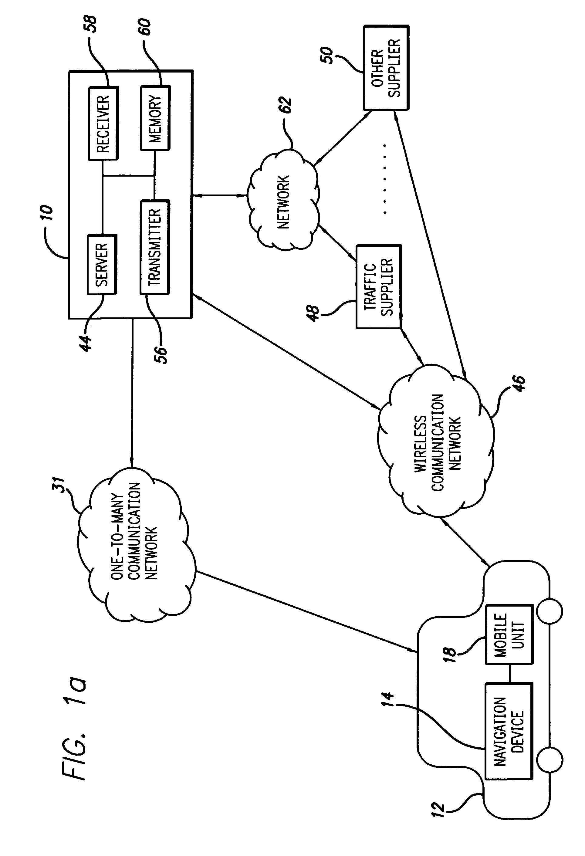
[0069]The present invention is directed to a system and method for facilitating the exchange of traffic information between a remote location and a vehicle. In particular, the present invention is directed to a system and method that includes a vehicle that exchanges traffic information with the remote location by way of one or more communication networks.

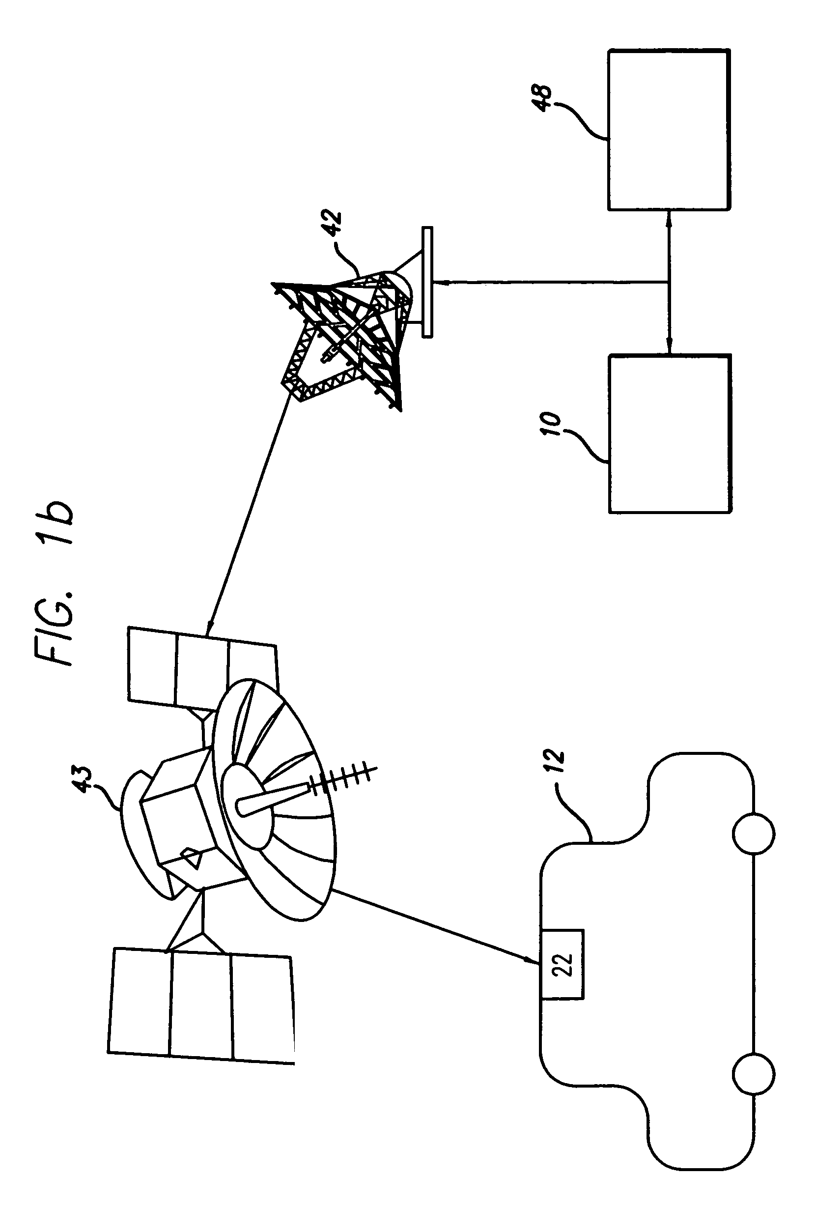
[0070]FIG. 1a shows a first embodiment of a system for facilitating the exchange of information between a remote location 10 and a vehicle 12 pursuant to aspects of the invention. The vehicle 12 includes a navigation device 14. Referring now also to

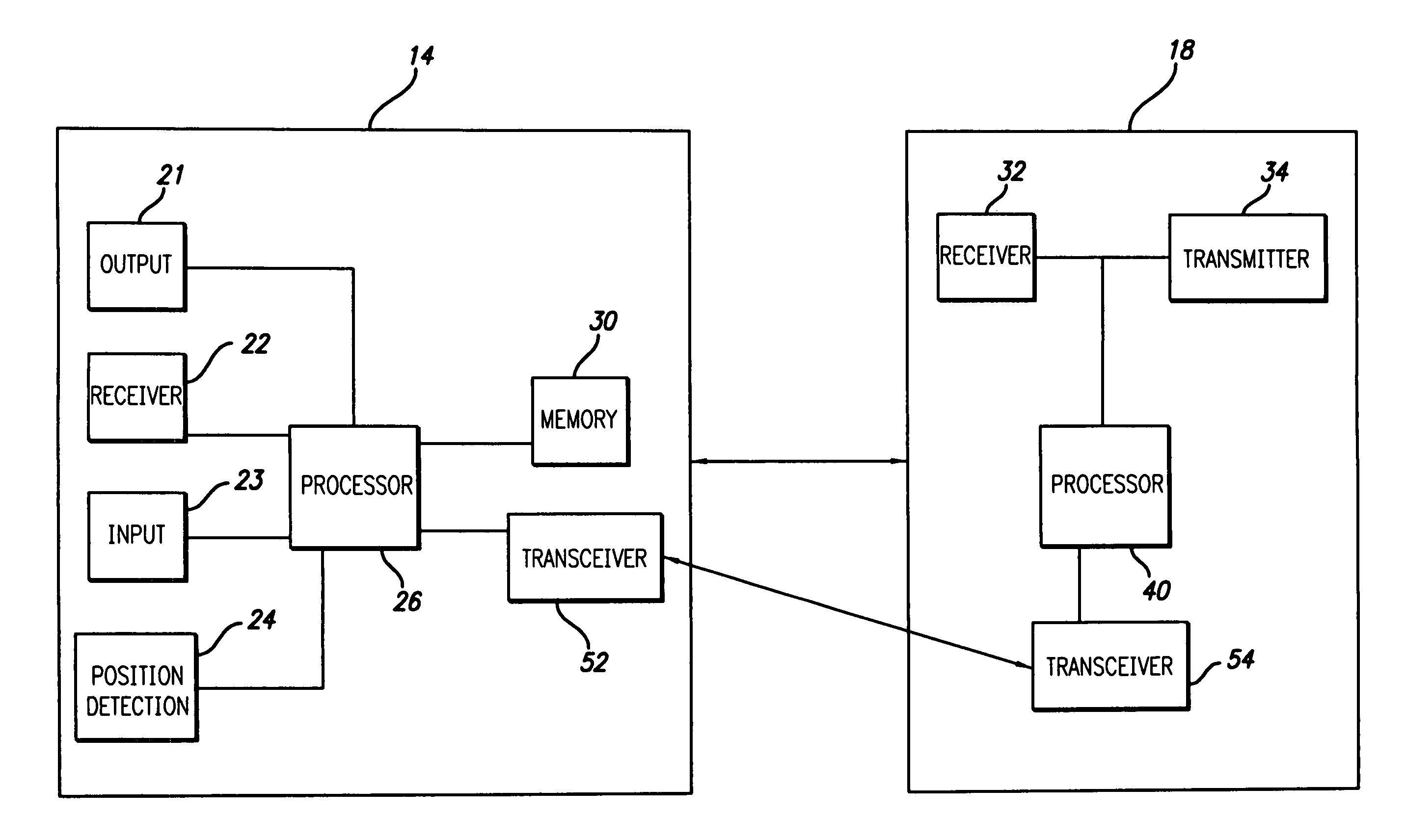
[0071]FIG. 1c, the navigation device 14 may include an output unit 21, a receiver unit 22, an input unit 23, a position detection unit 25, a navigation memory unit 30, a navigation processor unit 26, and an RF transceiver unit 52 that are all in electrical communication with one another. The navigation memory unit 30 includes at least a portion of a user profile and, in some embodiments,...


PUM


Abstract

Traffic information, including flow information and incident information, obtained through a traffic management system for providing and facilitating the exchange of traffic information between a remote location and a vehicle may be used in route calculation by a navigation device. The navigation device may recalculate a route based on anticipated user error. Alternatively, the navigation device may recalculate a route using received traffic information triggered by the receipt of a traffic information update, or triggered by the passage of an amount of time. The broadcast rate of traffic information updates may vary temporally (providing more frequent updates during peak commute times) or geographically (providing more frequent updates to metropolitan areas with increased traffic information needs). If route calculation is triggered by an elapsed amount of time, the amount of time may vary to be shorter during peak commute times. Additional route calculation techniques allow the incorporation of historical traffic information or the use of the most recent traffic information if incomplete traffic information is available. Still further route calculation techniques may calculate a best route by avoiding zigzagging or evaluating an assigned cost of a potential route.

Description

RELATED APPLICATION INFORMATION[0001]This application claims the benefit pursuant to 35 U.S.C. § 119(c) of U.S. Provisional Patent Application Ser. No. 60 / 560,087, entitled “Method and System for Traffic Management Between a Vehicle and a Remote Location,” which was filed with the U.S. Patent and Trademark Office on Apr. 6, 2004.BACKGROUND OF THE INVENTION[0002]1. Field of the Invention[0003]The present invention relates generally to a system for providing information between vehicles and a remote location and for providing traffic management and vehicle navigation information between a vehicle and the remote location, and more specifically to a system and method for calculating routes by a traffic management system.[0004]2. Description of Related Art[0005]Navigation systems for determining a route from a start point to a destination point are well known in the art. In addition, navigation systems having capabilities for determining the geographic position of a reference point are a...

Claims


Application Information

Patent Timeline
Patent Type & Authority Patents(United States)
IPC IPC(8): G01C21/34G08G1/0968
CPCG01C21/3415G01C21/3694G08G1/096811G08G1/096844
Inventor UYEKI, ROBERTTAMURA, KAZUYAOHKI, ERIC SHIGERUKURCISKA, MAJA
Owner HONDA MOTOR CO LTD
Why Eureka
Try Eureka