Streaming and interactive visualization of filled polygon data in a geographic information system

a geographic information system and polygon data technology, applied in the field of mapping systems, can solve the problems of limited usefulness of conventional geographic information systems in both their overall functionality and user interfa

Active Publication Date: 2010-06-29
GOOGLE LLC
View PDF55 Cites 265 Cited by
  • Summary
  • Abstract
  • Description
  • Claims
  • Application Information

AI Technical Summary

Benefits of technology

The present invention provides a computer-implemented method for streaming and interactive visualization of filled polygon data in a geographic information system (GIS). The method involves receiving a complex polygon dataset, subjecting it to height-based pre-filtering, dividing it into smaller sets called quads, simplifying the geometry in the quads to form a set of less complex polygons, and storing it for subsequent incremental streaming in response to client fly-through requests. The method may also include clipping polygons that fall on quad boundaries, generating additional geometry in the form of newly introduced vertices and edges, and preserving polygon features represented in the complex polygon dataset. The method allows for interactive frame rates on the client and provides a more efficient way to handle and display large amounts of geographic data.

Problems solved by technology

The technical problem addressed in this patent text is the limitations of current geographic information systems (GIS), including inflexible searches and interfaces. These systems require users to select specific search parameters, making it difficult to find relevant information without narrowing down the search results. There is a need for more flexible and efficient GIS tools that allow users to access a wider range of data while still interpreting search queries accurately.

Method used


Image

  • Streaming and interactive visualization of filled polygon data in a geographic information system
  • Streaming and interactive visualization of filled polygon data in a geographic information system
  • Streaming and interactive visualization of filled polygon data in a geographic information system

Examples


Embodiment Construction

[0023]Geographic information systems (GIS) and techniques are disclosed that provide users with a greater degree of flexibility, utility, and information. The system may be a distributed geographic information system (DGIS) including multiple components the communicate with one another. For purposes of this disclosure, assume that “GIS” includes both GIS and DGIS configurations.

[0024]General Overview

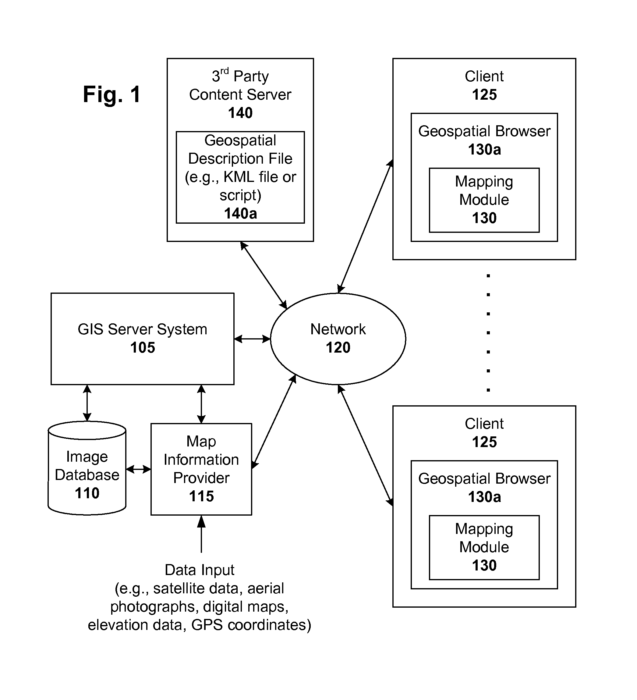
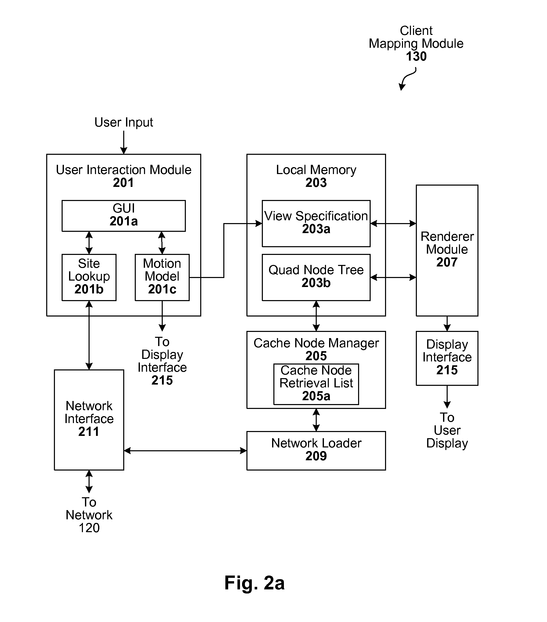
[0025]A GIS configured to carryout the techniques described herein can be implemented, for example, in a client-server architecture. Other configurations will be apparent in light of this disclosure. In accordance with one such embodiment of the present invention, client-side software operates (in conjunction with server-side software) to bring images of the Earth and other geospatial information to a user's computer so they can be seen by the user. In one example case, the client software is implemented using various software objects that are grouped in modules according to different fu...


PUM


Abstract

Interactive geographic information systems (GIS) and techniques are disclosed that provide users with a greater degree of flexibility, utility, and information. A markup language is provided that facilitates communication between servers and clients of the interactive GIS, which enables a number of GIS features, such as network links (time-based and/or view-dependent dynamic data layers), ground overlays, screen overlays, placemarks, 3D models, and stylized GIS elements, such as geometry, icons, description balloons, polygons, and labels in the viewer by which the user sees the target area. Also, “virtual tours” of user-defined paths in the context of distributed geospatial visualization is enabled. Streaming and interactive visualization of filled polygon data are also enabled thereby allowing buildings and other such features to be provided in 3D. Also, techniques for enabling ambiguous search requests in a GIS are provided.

Description


Claims


Application Information

Patent Timeline
Owner GOOGLE LLC
Why Eureka
Try Eureka