System for capturing, characterizing and visualizing lidar and generic image data

a generic image data and system technology, applied in the field of objects and feature extraction in photographs, can solve the problems of no system offering a method to capture, characterize and visualize fundamentally discrete distribution data, and no lidar elevation data lends itself to filling in missings

Active Publication Date: 2012-03-20
HSU SHIN YI
View PDF22 Cites 14 Cited by
  • Summary
  • Abstract
  • Description
  • Claims
  • Application Information

AI Technical Summary

Benefits of technology

[0028]In accordance with the present invention, there is provided a system that offers a method of capturing, analyzing, and visualizing a matrix of data for object and feature extraction. This is accomplished by reading a matrix of data represented by a plurality of data types into a processor via a data capture system. The matrix of data is overlaid by a control grid to form a regular matrix having a plurality of cells. A data search spatial radius is created from a point in each cell. Data is then processed from the matrix and certain characteristics are captured and represent each variable in each cell of the matrix, and then output, respectively.

Problems solved by technology

Inherently, LIDAR data points are not regularly spaced, and non-edited, point cloud LIDAR elevation data do not lend themselves to filling in missing data points by interpolation.
Although the IDW or any other interpolation technique can be used to estimate the building height, the process is illogical, and can lead to discrepancies.
Currently, no system offers a method to capture, characterize, and visualize fundamentally discrete distribution data, such as LIDAR data, and extends the process to include generic image data for object and feature extraction.

Method used


Image

  • System for capturing, characterizing and visualizing lidar and generic image data
  • System for capturing, characterizing and visualizing lidar and generic image data
  • System for capturing, characterizing and visualizing lidar and generic image data

Examples


Embodiment Construction

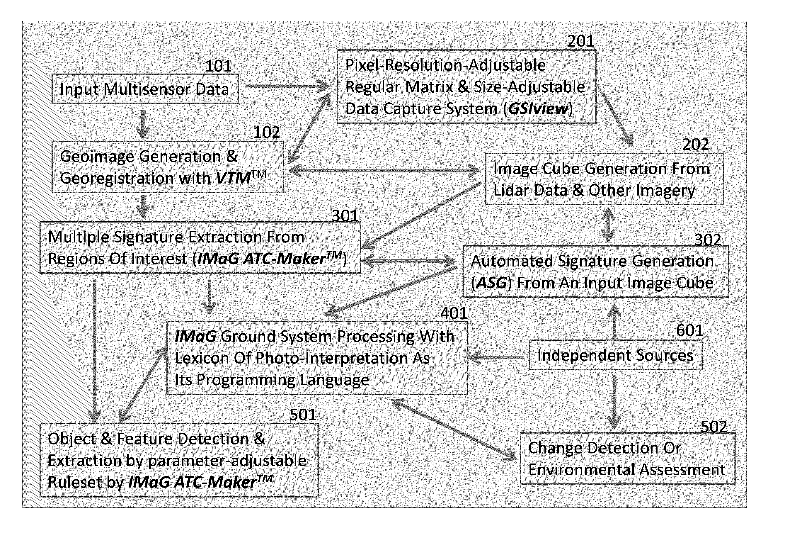
[0047]The invention features a method and system for extracting objects and features in photographs by capturing, analyzing, and visualizing a matrix of data that had been previously extracted from the aforementioned photographs. The regularly, or irregularly distributed data is then fed into a processor as a matrix of data points by the capture system. The captured data then undergoes through a parameter specific rule set and is then outputted by the system.

[0048]“Earth's Technological Satellite (ERTS), LANDSAT, Global Mapper, Geospatial Imagery Viewer, and GSlview” are terms used within the application that are either not registered or dead trademarks.

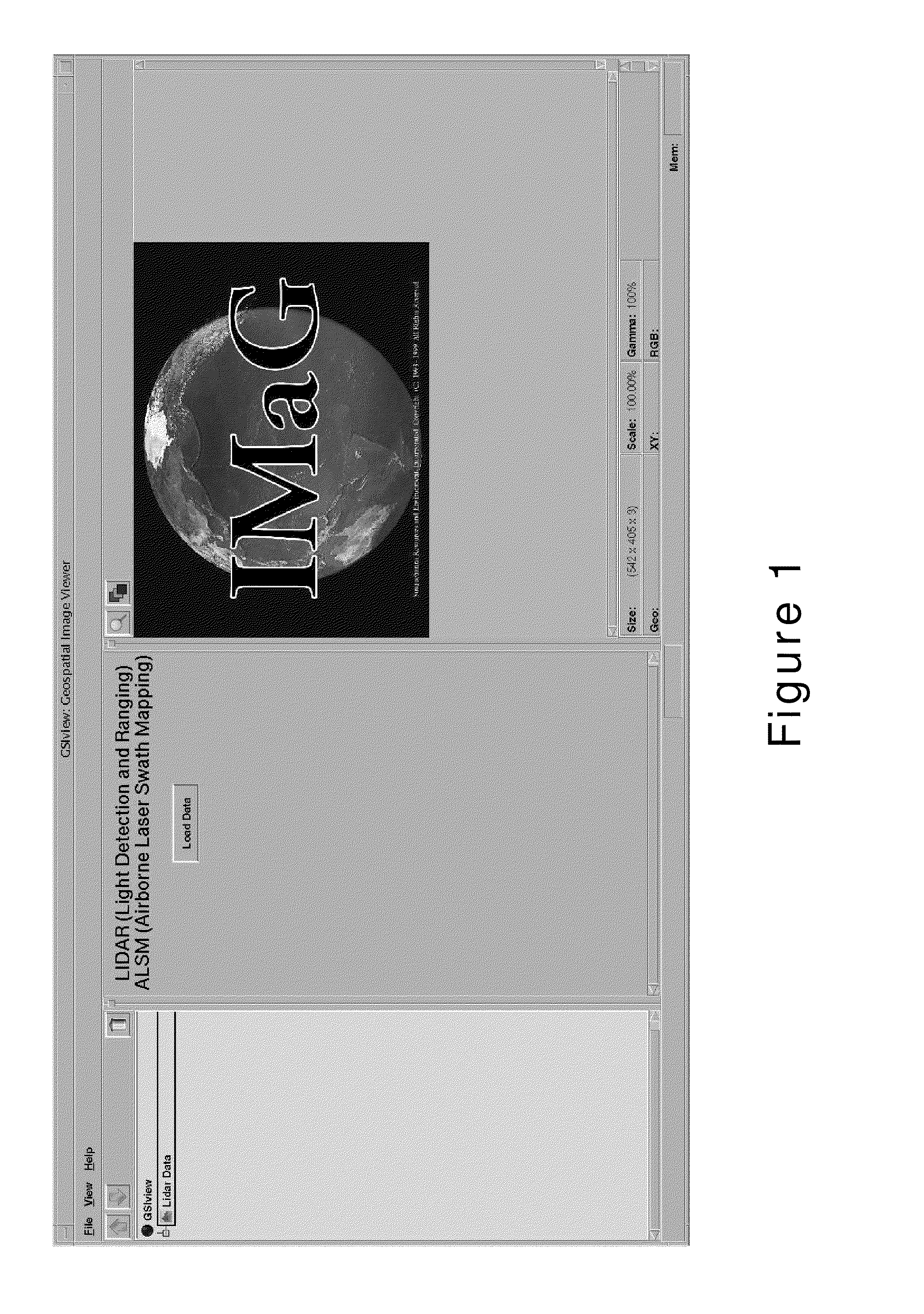
[0049]FIG. 1 depicts a data input GUI from GeoSpatial Imagery (GSI). A “load data” command reads the irregular or regular matrix data into the inventive system entitled GSlview.

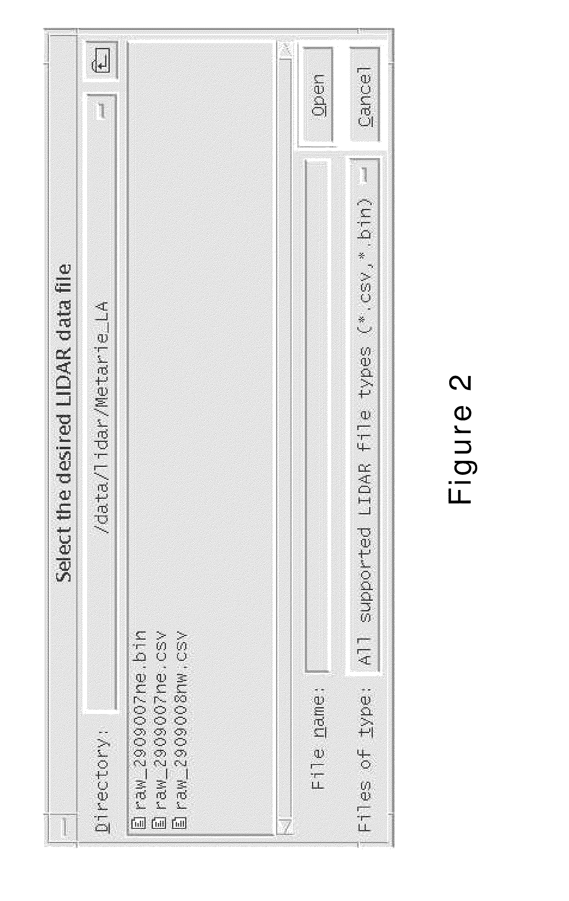
[0050]FIG. 2 shows an example of LIDAR data in common separated vector (csv) or binary (bin) format to be read in.

[0051]FIG. 3 shows the graphical user interf...


PUM


Abstract

A system that offers a method of capturing, analyzing, and visualizing a matrix of data for object and feature extraction. This is accomplished by reading a matrix of data represented by a plurality of data types into a processor via a data capture system. The matrix of data is overlaid by a control grid to form a regular matrix having a plurality of cells. A data search spatial radius is created from a point in each cell. Data is then processed from the matrix and certain characteristics are captured and represent each variable in each cell of the matrix, and then output, respectively.

Description

FIELD OF THE INVENTION[0001]The present invention relates to object and feature extraction in photographs and, more particularly, to object and feature extraction from LIDAR and generic image data.BACKGROUND OF THE INVENTION[0002]Since the launch of the Earth's Technological Satellite (ERTS), now known as LANDSAT, in 1972, numerous software packages have been developed and used to visualize and analyze multispectral imagery (MSI) data. Since the vast majority of MSI data have been prepared in a form of a regular matrix where missing data points are extremely rare, users in general have had no problem in filling in missing data. Thus, such users do not need to examine whether given software has an option to handle irregular data points, or whether the method is appropriate.[0003]With an increasing use of Light Detection and Ranging (LIDAR) and with the advancement of GPS as a navigation system since the 1980s, users of remotely sensed imagery must handle missing data points and must ...

Claims


Application Information

Patent Timeline
Patent Type & Authority Patents(United States)
IPC IPC(8): G06K9/46G06V10/58
CPCG01S17/87G01S17/89G06K9/00637G06K2009/00644G06K2009/4657G06V20/176G06V20/194G06V10/58
Inventor HSU, SHIN-YI
Owner HSU SHIN YI
Why Eureka
Try Eureka