3-D golf course navigation device and image acquisition method

a golf course and navigation device technology, applied in the field of golf, can solve the problems of geospatial data used, conventional golf gps devices suffer from a number of drawbacks, and the production of commercial golf gps devices, so as to improve accuracy, improve playability, and improve the effect of informed decision-making on the cours

Inactive Publication Date: 2013-03-12
ROBERTS GREGG
View PDF8 Cites 6 Cited by
  • Summary
  • Abstract
  • Description
  • Claims
  • Application Information

AI Technical Summary

Benefits of technology

[0016]An advantage of the invention is that it provides better accuracy (both visually and distance related) through measuring and calculating the change in the hypotenuse or change in topographic elevation between certain points. A general assumption is that golf courses are not flat, therefore, the horizontal mapping accuracy of a golf course navigation devices are directly dependent upon the measurement and calculation of the hypotenuse to determine the correct and highly accurate horizontal, latitude and longitudinal position of a relative point or distance to enable a player to make better informed decisions on the course, which should lead to faster play. This means that a player or user has the correct ranging, distancing, and course management information, which results in a higher accuracy and precision of shots, and an increased pace of play and performance.

Problems solved by technology

Conventional golf GPS devices suffer from a number of drawbacks.
First, the geospatial data used (satellite imagery and differential GPS collection systems) in the production in commercially available golf GPS devices, such as those produced by GPS Industries, Sky Golf's Sky Caddie, and Callaway's uPro is very low resolution and is no better than five (5) to thirty (30) yards or meters.
If the golf GPS device indicates that the remaining distance to a pin is 150 yards when it is really 160 yards, then a player hitting an 8-iron instead of a 7-iron will come up well short—an unnecessary error that may result in the player's ball coming to rest in a hazard rather than on the green.
This type of inherent error is not well suited for a game considered by many to be a game of inches.
The accuracy of conventional GPS devices is further complicated as some courses are better fit to use the capabilities of GPS than others.
Accordingly, courses with lots of trees and other types of natural obstructions are less suitable for golf GPS devices.
Objects such a mountains or buildings between the satellite and the receiver can produce significant error, sometimes up to 30 meters.
The graphics displayed on conventional GPS devices are rudimentary at best.
However, this oblique imagery and perspective view was acquired by Pictometry's Oblique camera system and is not considered a mapping or calibrated camera system usable for mapping or civil engineering.
For a game that depends on where and the way a golf ball lands and bounces, conventional golf GPS systems are woefully inadequate.

Method used


Image

  • 3-D golf course navigation device and image acquisition method
  • 3-D golf course navigation device and image acquisition method
  • 3-D golf course navigation device and image acquisition method

Examples


Embodiment Construction

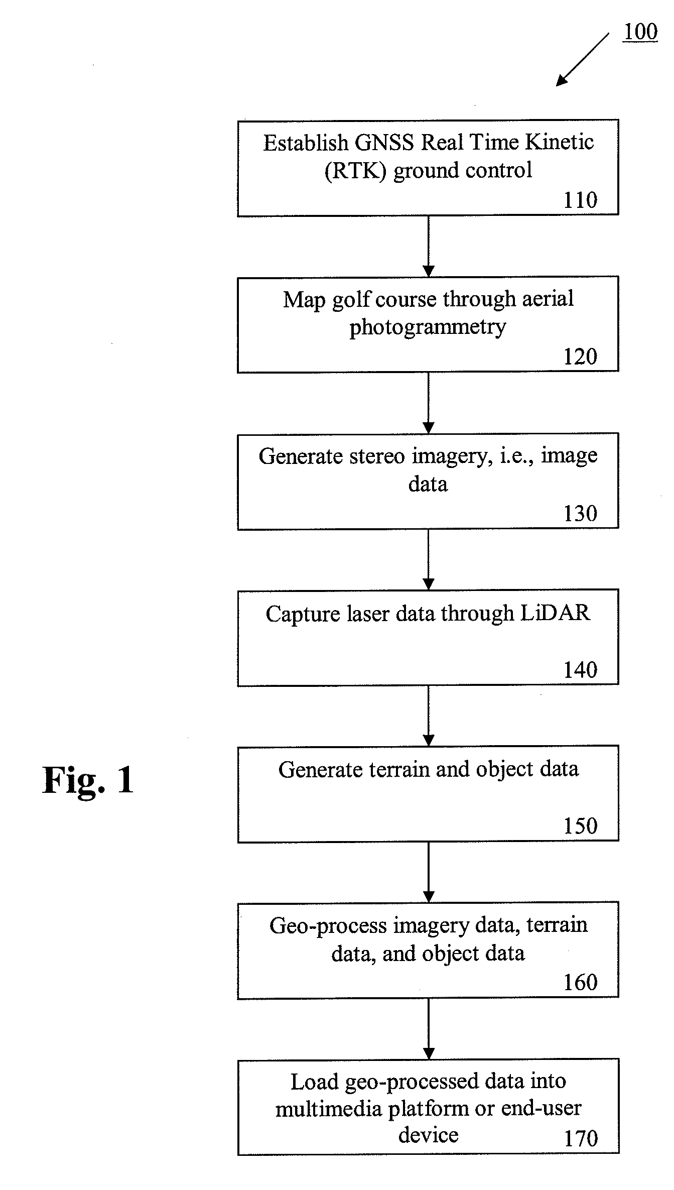
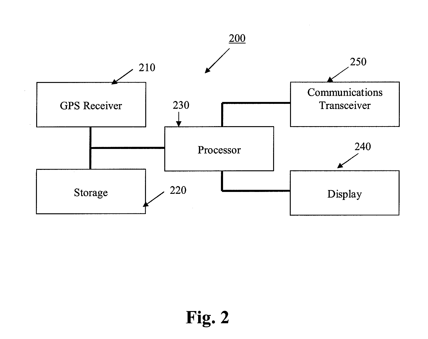
[0024]Further features and advantages of the invention, as well as the structure and operation of various embodiments of the invention, are described in detail below with reference to the accompanying FIGS. 1-5, wherein like reference numerals refer to like elements. Although the present invention is described in the context of a golf course, the navigation and display technology described herein may be implemented in other geospatial applications such as, but not limited to parks, hiking trails, ski resorts, amusement parks, and race courses.

[0025]The present invention provides a golf course navigation device that implements three-dimensional data and software for accurate distance measurements. In an embodiment of the invention, three data sets are acquired for each golf hole: (1) image data, (2) geospatial terrain data including elevation measurements, and (3) object data pertaining to trees, bushes, water hazards, buildings, and any other objects present (collectively referred t...


PUM


Abstract

The present invention provides three-dimensional, topographic data (x,y,z) for a golf course navigation device. In an embodiment of the invention, three data sets are acquired for each golf hole: (1) geospatial digital image data, (2) geospatial terrain data including elevation and topographic measurements, and (3) object data pertaining to trees, bushes, water hazards, buildings, and any other objects present. Each hole is mapped using high resolution airborne photogrammetry and in some cases, light detection and ranging acquisition sensors. Geospatial, three-dimensional terrain data is acquired using a photogrammetry and / or stereo photogrammetry compilation. Object data is acquired from measurements taken from ground level. From all of this acquired data, a three-dimensional (x,y,z) geospatial model is built and then integrated into 3-D gaming, visualization and web mapping environments such as Microsoft Bing Maps, Google Earth, and various mobile and golf cart mounted, golf course navigation systems.

Description

CROSS-REFERENCE TO RELATED APPLICATION[0001]The present application claims priority under 35 U.S.C. §119(e) to U.S. Provisional Patent Application No. 61 / 238,652, entitled “3-D Golf GPS Navigation Device and System,” and filed Aug. 31, 2009, the disclosure of which is incorporated by reference herein in its entirety.BACKGROUND OF THE INVENTION[0002]1. Field of Invention[0003]This invention relates to golf and more specifically, to three-dimensional (3-D) mapping, photogrammetry, and light detection and ranging (LIDAR) techniques used to produce the software and data required for implementation into a series of golf course navigation software and physical hardware devices that use satellite navigation and geospatial database systems for assisting golf players, fans, and viewers in course navigation, visualization, management, and administration.[0004]2. Description of Related Art[0005]Golf is a game of accuracy, precision and distance. Without an expert caddie along, there's a lot of...

Claims


Application Information

Patent Timeline
Patent Type & Authority Patents(United States)
IPC IPC(8): G01C21/00G06K9/00
CPCA63B57/00G01C21/20G01S19/19
Inventor ENGSTROM, KARL
Owner ROBERTS GREGG
Why Eureka
Try Eureka