
Eureka
For R&D, Eureka makes reading and utilizing patents & technical documents easy.
Eureka AIR
Designed for self-driven R&D workflows. Generate viable solutions, solve complex R&D challenges, empower your innovation with AI.

Eureka Materials
Designed for material experts only. Revolutionize your material R&D, from search, analyze, to developing new materials.

TechResearch
Generate reliable direction feasibility study reports for your R&D in just a few steps.

TechSeek
Discover and master advanced knowledge NOW. Basics, ideas, possibilities, all at once.

TechMind
As an expert in R&D Theories, TechMind can generates customized viable solutions instantly.

TechRisk
Analyze your overall solution with one click, know your potential R&D risks in advance.

TechMonitor
Get weekly tech updates, stay abreast of the latest tech innovations and key insights.
Gravity survey data processing
- Summary
- Abstract
- Description
- Claims
- Application Information
AI Technical Summary
Benefits of technology
Problems solved by technology
Method used
Image

Examples
second embodiment
[0087]In the method a modified Fourier basis functions technique is employed. In this method a two-dimensional Fourier expansion is used to represent the measured data but each two-dimensional coefficient Amn of each component (Amneikmxeikny) of the 2-D Fourier transform of the gravity field is rewritten as a product of a position independent coefficient, (Cmn) multiplying a height-dependent coefficient (e−|kmn|z). That is, Amn=Cmne−|kmn|z. Explicitly, one can write the gravity field of any mass distribution in the form
[0088]gg(x,y,z)=∑m∑nCmnⅇⅈkmxⅇⅈknyⅇ-kmnz,kmn=(km2+kn2)
[0089]In the language of Fourier transforms, Amn is the 2-D Fourier transform of the gravity field. This representation is completely general and each component of the expansion representing the gravity field explicitly obeys Laplace's Equation (when differentiated the multipliers of the height-dependent coefficient and of the 2D components cancel). What is now made explicit is the height dependence of...
first embodiment
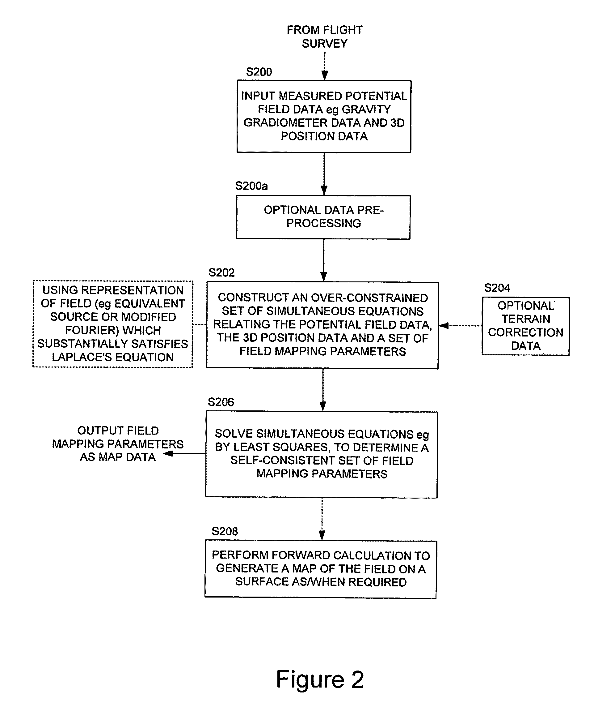
[0092]Broadly speaking, coefficients for the expansion are determined in a manner virtually identical to that described above for the equivalent source method. Once one has chosen the maximum wavelength of interest for each direction, and of the orientation and origin of the coordinate system for measurement, the value of the basis functions can be determined at every point in space. Once this is done, the same difference squared function, S, is calculated for the measured quantity and the best values for the coefficients Cmn are determined by minimising such function with respect to variations in Cmn. Thus, as with the first embodiment described above, a set of simultaneous equations is generated which can be solved for the Fourier expansion coefficients. These coefficients can then be employed to determine (by forward calculation) the gravity or gravity gradient on any two-dimensional surface, that is to provide a map. It will be recognised that with this (and the preceding) embod...
PUM
 Abstract
Description
Claims
Application Information
 - R&D Engineer
- R&D Manager
- IP Professional
- Industry Leading Data Capabilities
- Powerful AI technology
- Patent DNA Extraction
Browse by: Latest US Patents, China's latest patents, Technical Efficacy Thesaurus, Application Domain, Technology Topic, Popular Technical Reports.
© 2024 PatSnap. All rights reserved.Legal|Privacy policy|Modern Slavery Act Transparency Statement|Sitemap|About US| Contact US: help@patsnap.com