Method and apparatus for automatically ensuring consistency among multiple spectrum databases

a technology of automatic assurance and database, applied in the field of cognitive radio communication systems, can solve the problems of large number of steps and computations, inconsistent incumbent protection, and inability to automatically ensure etc., and achieve the effect of ensuring consistency between multiple spectrum databases, inadvertently or deliberately corrupting geo-location data or algorithms during operation

Active Publication Date: 2013-11-19
MOTOROLA SOLUTIONS INC
View PDF10 Cites 1 Cited by
  • Summary
  • Abstract
  • Description
  • Claims
  • Application Information

AI Technical Summary

Problems solved by technology

However, there are a large number of steps and computations required to determine channel availability information.
This may result in inconsistent incumbent protection results between the different geo-location databases due to various issues such as differing protection algorithm quantization / interpolation methods, geo-spatial reference points when channel availability results are gathered from multiple databases, or times in which the protection data in each geo-location database is updated.
Moreover, the geo-location data or algorithms may become inadvertently or deliberately corrupted during operation.
In any event, incorrect channel availability information may cause impermissible interference to protected devices if the secondary devices begin to operate in the desired location.
Differing geo-location databases may interpret the protection status differently, leading to discrepancies in channel availability information among databases.
Secondary devices of all types are typically not allowed to operate with these co-channel protected areas.
This poses additional risk for differing databases having differing protected entity information, which could result in protection information (i.e., channel availability) discrepancies between different databases.
The generally accepted propagation models, however, only provide statistical average data for signal reception, and are subject to errors in the field due to a variety of reasons (e.g., terrain variations, antenna variations, etc.).
For example, an unlicensed secondary device with a poor transmit spectral mask operating two channels away in frequency, but in close proximity to another secondary cognitive radio device, may cause a significant amount of interference to the other cognitive radio device, and significantly lower the channel quality of a previously available (or desirable) channel.
Generally, the secondary device is not allowed to transmit co-channel inside of a protected service contour to protect incumbent receivers inside the primary system's service contour.
Also, differences in a geo-spatial reference grid may also result in differing database results (see below).
Other items such as terrain database resolution are not specified, which may lead to minor differences in calculating the protected service areas among different database vendors.
The various computations are complicated enough, however, to offer several opportunities for minor errors or variations to be introduced.
Another avenue is the use of differing spatial grid reference points among between the different databases, which can cause minor differences in results among multiple databases.
These minor differences will typically result in differing channel availability results around the edges of these protected areas.
The significant proportion of errors may occur inadvertently such as corrupted data or algorithms in the database(s) or deliberately due to unauthorized tampering with the database(s).
However, contour calculation is not an exact science.
Although it may be desirable to specify that each database adhere to the exact same computational algorithm, this may be impractical due to a number of implementation issues.
Given a high power transmitter with a very large service area, since errors are proportional to contour distances (R), a large error may result due to the difference between the actual distance R (e.g., determined at 10° increments) and the extrapolated distance r. For example, a 500 kW ERP, 400 m HAAT omni-directional UHF DTV station has contour radius of 99.6 km results in a maximum contour error of 379 m.
Note that larger contour distances generally mean larger absolute errors.
Antenna patterns are generally defined in 10° steps in databases such as the FCC CDBS database, the F-curves in the FCC CDBS database are generally non-linear functions, and real-world RF environments will further complicate the contour calculations.
It is expected, for example, that the largest errors occur along contour edges with the highest rates of curvature and that a greater number of potential errors exist near nulls of patterns.
This can significantly alter nulls in the contour patterns.

Method used


Image

  • Method and apparatus for automatically ensuring consistency among multiple spectrum databases
  • Method and apparatus for automatically ensuring consistency among multiple spectrum databases
  • Method and apparatus for automatically ensuring consistency among multiple spectrum databases

Examples


Embodiment Construction

[0021]Before describing in detail the various embodiments, it should be observed that such embodiments reside primarily in combinations of method steps and apparatus components to assure accurate and consistent channel availability results, which are essentially independent of the geo-location database queried. The comparison is automatic and takes into account spatial and temporal consistency issues between the databases, whose results are independently derived, allowing small discrepancies to exist while retaining overall consistency. The comparison permits protected users to remain protected from excessive interference caused by secondary devices accessing the frequency spectrum.

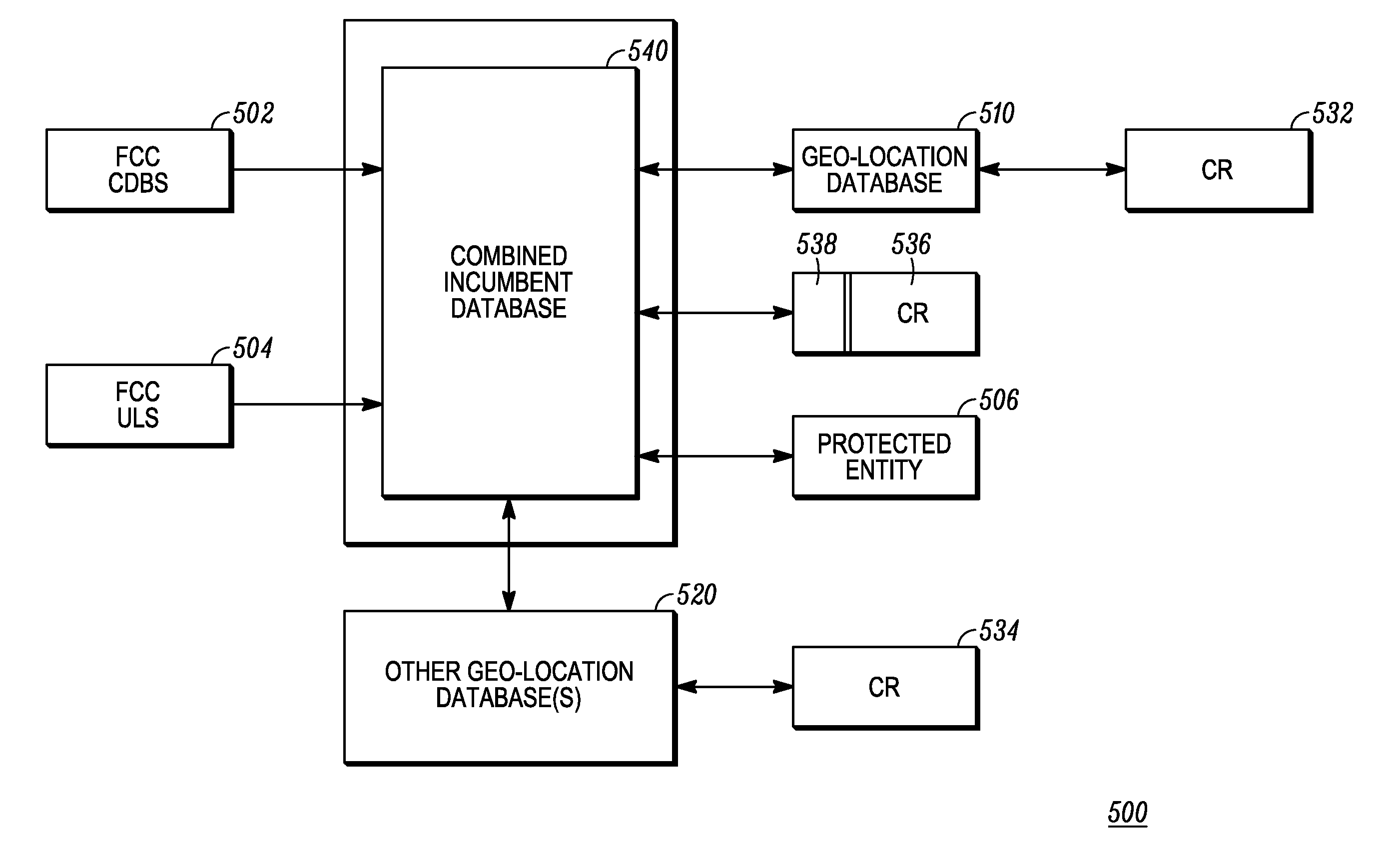
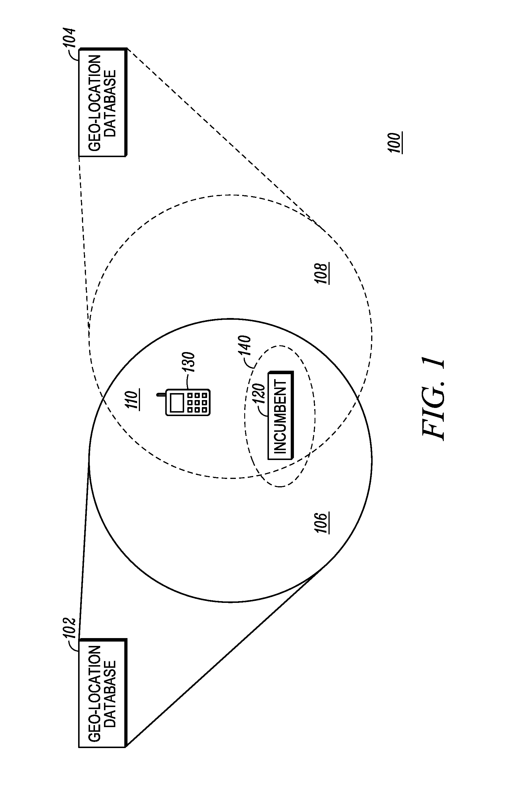
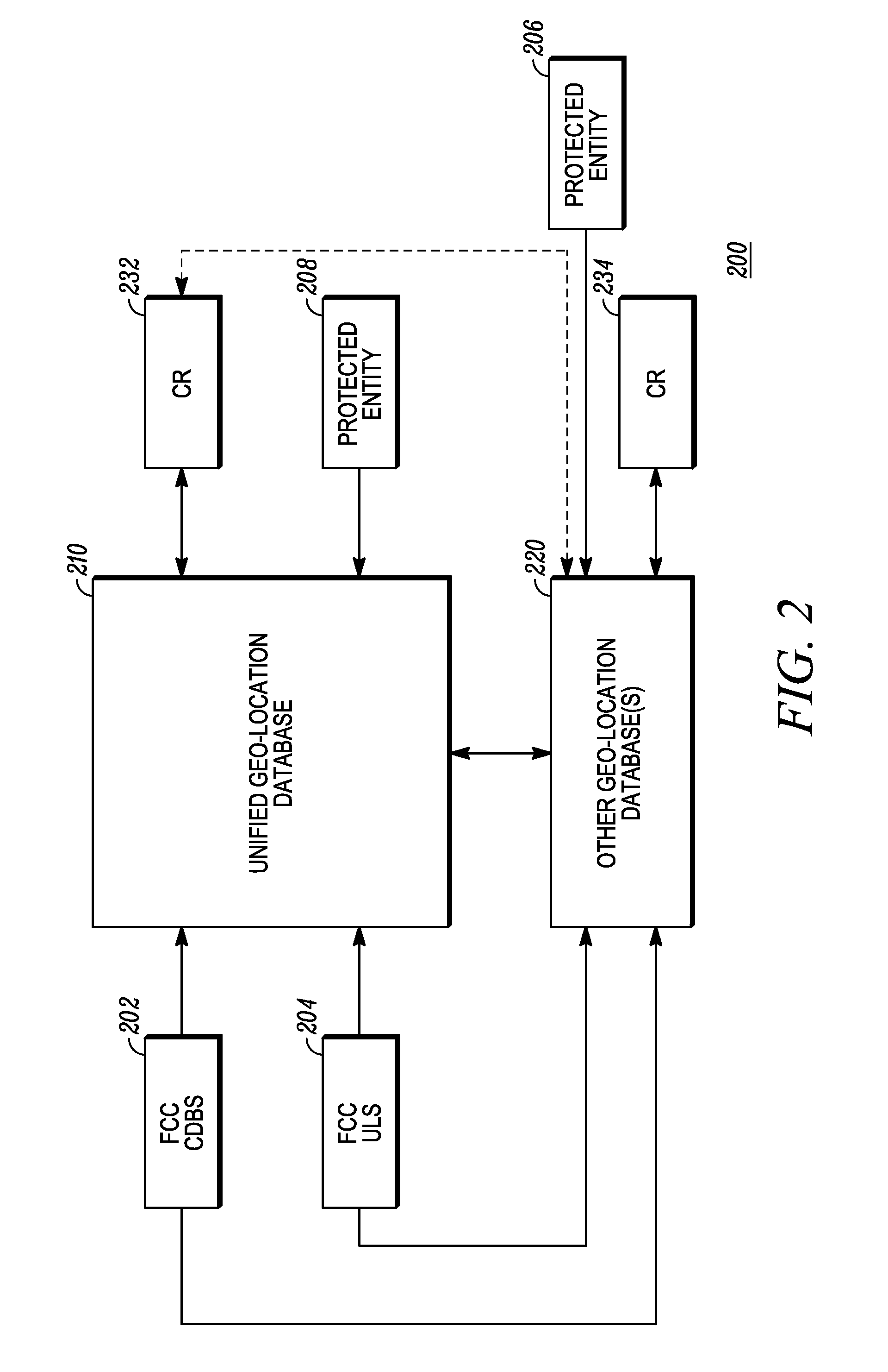
[0022]FIG. 1 illustrates one embodiment of a communication system 100 with multiple geo-location databases 102, 104 that cover overlapping geographical areas 106, 108. Within the geographical areas 106, 108 lie one or more incumbent systems (illustrated as incumbent device 120) to be protected and unlicen...


PUM


Abstract

An apparatus and method of providing accurate and consistent open spectrum results for secondary devices from different geo-location databases is presented. The results, which may be independently derived by each database, are independent of the database queried. The comparison permits some amount of latitude in spatial and temporal consistency between the databases as errors are only indicated if the temporal or spatial discrepancies are pervasive. In addition, large percentages of different locations showing discrepancies when compared also lead to corrective action being taken. Corrective actions that may be taken include forcing problematic databases to update, shunting requests by secondary devices in the problematic locations to acceptable databases or shutting down the problematic databases entirely.

Description

RELATED APPLICATIONS[0001]This application claims benefit under 35 U.S.C. §119(e) from U.S. Provisional Patent Application No. 61 / 250,602, commonly owned with this application by Motorola, Inc., filed Oct. 12, 2009, and entitled “METHOD AND APPARATUS FOR AUTOMATICALLY ENSURING CONSISTENCY AMONG MULTIPLE SPECTRUM DATABASES”, the entire contents of which being incorporated herein by reference.TECHNICAL FIELD[0002]The present application relates generally to cognitive radio communication systems and more particularly to a method and apparatus for automatically ensuring consistency among multiple spectrum databases.BACKGROUND[0003]In wireless communications, different frequency bands are set aside by the Federal Communications Commission (FCC) for different purposes. Users of a particular frequency band may be primary or secondary, licensed or unlicensed. Existing users of a particular frequency spectrum are called incumbents of that spectrum. Secondary devices, such as unlicensed Cogni...

Claims


Application Information

Patent Timeline
Patent Type & Authority Patents(United States)
IPC IPC(8): G06F17/30
CPCG06F17/30442G06F17/30592G06F16/283G06F16/2453
Inventor GURNEY, DAVID P.
Owner MOTOROLA SOLUTIONS INC
Why Eureka
Try Eureka