Generating an indoor map model

a technology of indoor map and model, applied in the direction of editing/combining figures or text, navigation instruments, instruments, etc., can solve the problems of non-uniform shape, non-compliance with easy representation of walking and indoor navigation environments, and the inability to accurately capture the relationship between possible destinations and navigable paths using traditional road graph models

Active Publication Date: 2015-06-09
GOOGLE LLC
View PDF23 Cites 4 Cited by
  • Summary
  • Abstract
  • Description
  • Claims
  • Application Information

AI Technical Summary

Problems solved by technology

In particular, walking and indoor navigation environments do not typically conform to easy representation via a series of interconnected line segments.
These environments may include non-uniformly shaped open spaces that intersect across line segments, instead of at points.
Generation of map representations of these environments using traditional road graph models may not accurately capture the relationship between possible destinations and navigable paths.

Method used


Image

  • Generating an indoor map model
  • Generating an indoor map model
  • Generating an indoor map model

Examples


Embodiment Construction

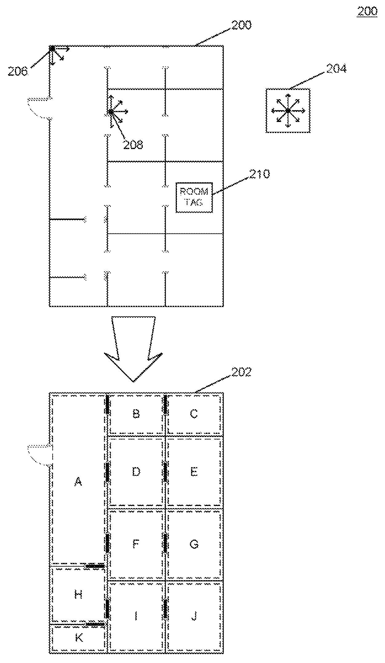
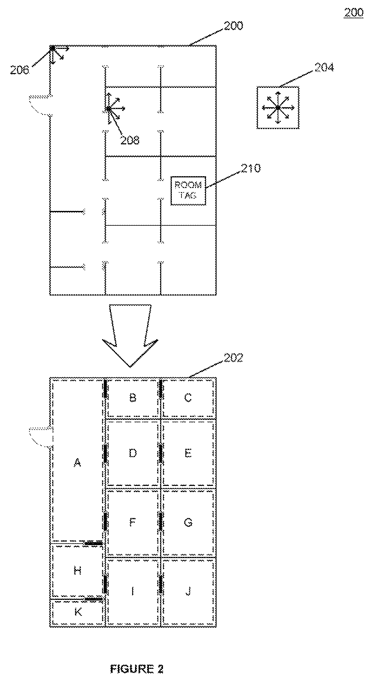
[0013]A method and system for generating an indoor map model are described here. Aspects of this disclosure provide for generation of a map model that can be used to perform navigation and route-finding operations. An image of a floor plan may be translated into an indoor map representation by assigning one or more colors to navigable space, and one or more colors to non-navigable space. Areas of navigable space may be analyzed to identify one or more polygons that fill the areas of navigable space. Adjacency relationships between polygons may be identified among the identified polygons. The indoor map representation may be provided to a client device as a series of vertices that describe the polygons and relationship data that identifies the adjacency relationships among the polygons.

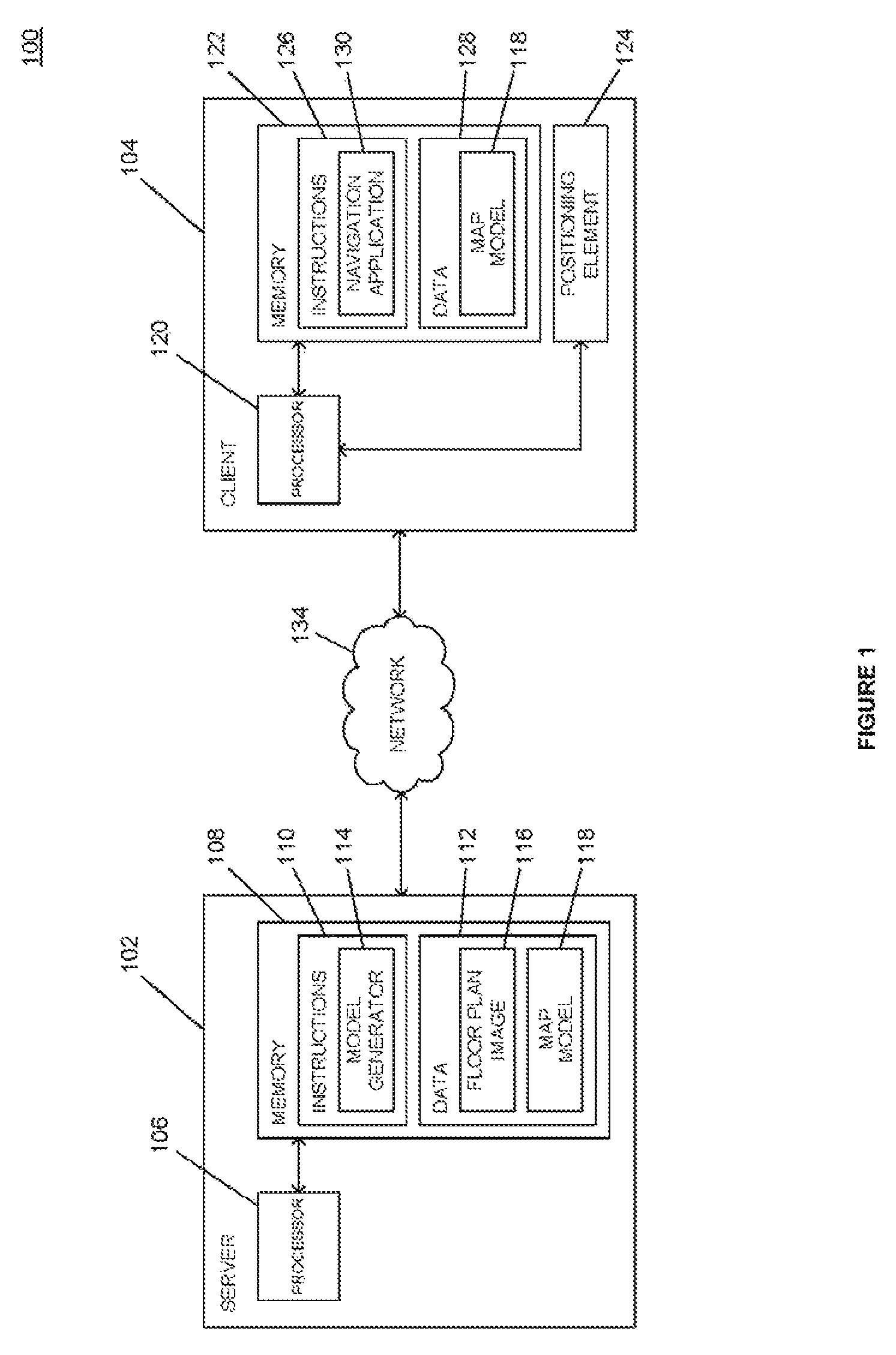
[0014]FIG. 1 is a system diagram depicting an example of an indoor navigation system 100 in accordance with aspects of the disclosure. As shown in FIG. 1, an example indoor navigation system 100 includ...


PUM


Abstract

A method and system for providing an indoor map representation are provided herein. Aspects of this disclosure provide a representation of an indoor map environment whereby navigable areas are represented by a series of convex polygons in adjacency relationships with one another. Image analysis may be performed on a floor plan image to identify navigable areas and to determine the boundaries of the polygons, such as by assigning one or more colors to navigable space and one or more colors to non-navigable space. Route-finding operations may be performed using the adjacency relationships to find a path from a source area to a destination area.

Description

CROSS REFERENCE TO RELATED APPLICATIONS[0001]The present application is a national phase entry under 35 U.S.C. §371 of International Application No. PCT / CN2012 / 070287, filed Jan. 12, 2012, published in English. The entire disclosure of the above-identified application is incorporated by reference herein.BACKGROUND[0002]The proliferation of smart phones and other mobile devices has placed more processing power in the hands of consumers than ever before. These mobile devices are capable of executing a variety of applications, including applications that assist with navigation and route-finding. Traditional global positioning system (GPS) navigation devices are used to assist automobile owners with driving operations from a source to a destination, and navigation software is generally developed with the use-case of driving directions in mind. These devices may provide map data in the form of a road graph, with valid driving paths represented by line segments which intersect at various ...

Claims


Application Information

Patent Timeline
Patent Type & Authority Patents(United States)
IPC IPC(8): G06T11/20G06T11/60G06T17/05G06K9/00G01C21/20G06T7/40
CPCG01C21/206G06T11/60G06T17/05G06K9/00637G06T7/408G06T11/206G06T7/90G06V20/176
Inventor LI, GUANFENGZHANG, FAENWANG, FENG
Owner GOOGLE LLC
Why Eureka
Try Eureka