System and method for vertical navigation based on GPS waypoints and autopilot programming

Active Publication Date: 2015-08-25
HONEYWELL INT INC
View PDF18 Cites 8 Cited by
  • Summary
  • Abstract
  • Description
  • Claims
  • Application Information

AI Technical Summary

Benefits of technology

[0004]Briefly, the present disclosure pertains to a system and method for achieving vertical navigation (VNAV) by using a satellite based navigation system exemplified by a GPS system and implementing the vertical navigation features in an autopilot unit interfaced to the satellite based navigation system. The autopilot reads waypoint information output from the satellite navigation system and receives VNAV altit

Problems solved by technology

EFIS systems can be quite expensive, out of the

Method used


Image

  • System and method for vertical navigation based on GPS waypoints and autopilot programming
  • System and method for vertical navigation based on GPS waypoints and autopilot programming
  • System and method for vertical navigation based on GPS waypoints and autopilot programming

Examples


example approach

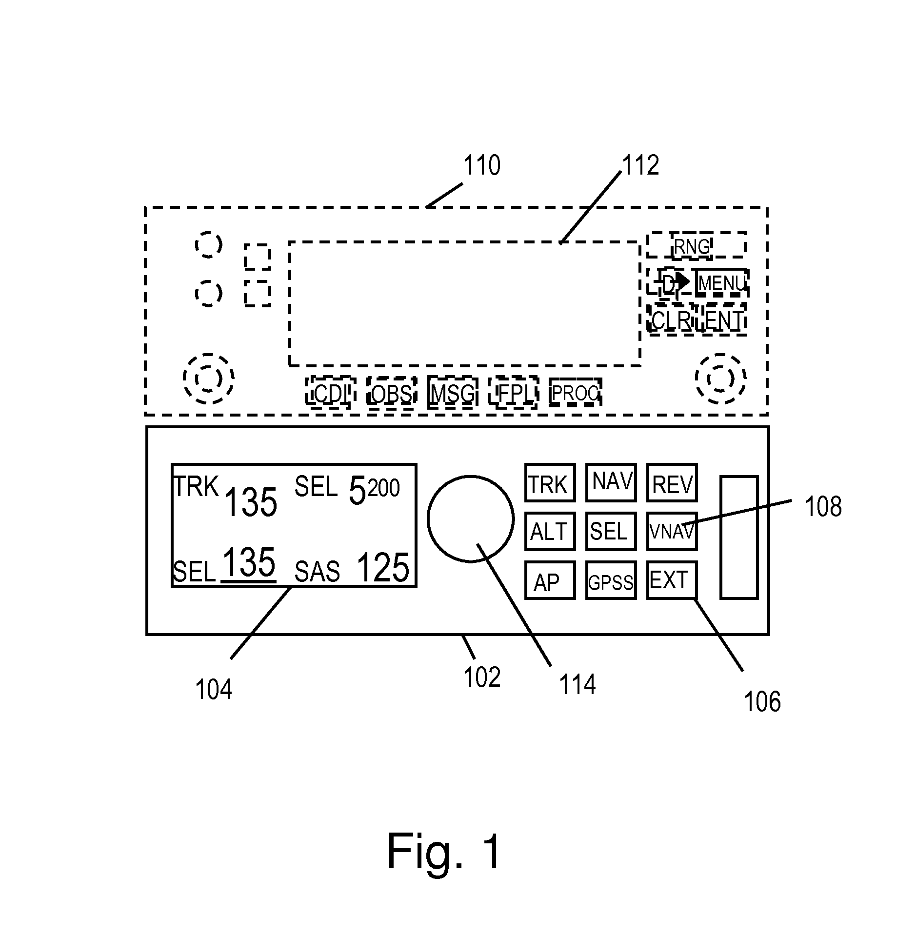
[0090]FIG. 5A-FIG. 5E illustrate the autopilot display during an exemplary approach.

[0091]FIG. 6 illustrates an altitude profile during an exemplary approach. Referring to the figures, FIG. 5A illustrates the autopilot display at point 602 in FIG. 6. The aircraft is operating in altitude hold mode at 1200 meters altitude 603, 502 ready to set up for the VNAV approach. The lateral mode is GPS steering (GPSS). The GPS has been programmed to follow a flight plan comprising waypoints ZOVPO (PPOA) 606 to POCBU 612 to H34614. The aircraft is approaching ZOVPO 606. GPS track is engaged (indicated by “+”506) and the VNAV is programmed (indicted by “V”508) for 761 meters altitude 510 at the next waypoint, POCBU. FIG. 5B shows the display upon crossing ZOVPO. The new altitude is 761 meters 510. The distance to POCBU is 6.1 km. The cursor is on altitude select indicating that rotating the knob 114 will change the target altitude 510.

[0092]FIG. 5C shows the display at point 606. At point 606, t...


PUM


Abstract

A system and method for achieving vertical navigation by using a satellite based navigation system exemplified by a GPS system and implementing the vertical navigation features in an autopilot unit interfaced to the satellite based navigation system. The autopilot reads waypoint information output from the satellite navigation system and receives VNAV altitudes and other commands from the pilot. The autopilot then performs VNAV calculations and guidance in accordance with the VNAV program. VNAV setup and progressive status are displayed on an economical small screen autopilot display. Modes are disclosed for exemplary GPS direct to waypoint VNAV, waypoint transition VNAV, multiple waypoint VNAV and other VNAV modes. Safety limits may be imposed on the VNAV program.

Description

RELATED APPLICATIONS[0001]This patent application claims the benefit under 35 USC 119(e) of provisional patent application 61 / 982,299 titled System and Method for Vertical Navigation Based on GPS Waypoints and Autopilot Programming” filed Apr. 21, 2014 by Barker et al, which is incorporated herein by reference in its entirety.FIELD OF THE INVENTION[0002]The present invention pertains generally to the field of aircraft autopilot navigation, more particularly, vertical navigation as it pertains to autopilot guidance.BACKGROUND[0003]Vertical navigation is a tool that can reduce pilot work load and fatigue and thus improve flight safety, especially in a high work load procedure such as an instrument approach in the presence of severe weather. Vertical navigation is typically offered in low end systems in the form of a pitch attitude hold mode, or vertical rate mode or altitude select mode. Some autopilots offer an altitude limit alert. High end integrated systems, often termed Electroni...

Claims


Application Information

Patent Timeline
IPC IPC(8): G05D1/00G05D1/06G05D1/04G01C21/20G01S19/38G01S19/01G05D1/08G01C23/00
CPCG05D1/0607G01C21/20G01S19/01G01S19/38G05D1/042G05D1/0825G05D1/08G05D1/0061G01C23/00G01S19/15
Inventor BARKER, ANDREWMASSENGALE, LUCASFOSTER, MOSS
Owner HONEYWELL INT INC
Why Eureka
Try Eureka