GPS-aided inertial navigation method and system

a technology of inertial navigation and inertial navigation, which is applied in the field of multisensor (multiimu and multigps) gps-aided inertial navigation system and method, can solve the problems of both burden and complexity, and the computational burden and software complexity are just a little greater, so as to achieve minimal additional computational burden, improve navigation accuracy, and reduce the effect of software changes

Active Publication Date: 2018-03-27
IMI SYST LTD
View PDF4 Cites 10 Cited by
  • Summary
  • Abstract
  • Description
  • Claims
  • Application Information

AI Technical Summary

Benefits of technology

[0009]The present system includes a mobile rigid body (‘vehicle’, e.g. aircraft) on which a plurality of inertial measurement units (IMUs) and one or more GPS antennas and receivers are fixedly installed. A navigation computer (NC) completes the navigation hardware, and interfaces all the above hardware elements. The present GPS-aided inertial navigation system and method fuse the data from all available sensors to produce the navigation solution (position, velocity, attitude). It is assumed that one has already developed a single-IMU / single-GPS INS, and one wishes to modify it and create a multi-GPS / multi-IMU INS with minimal software changes and with minimal additional computational burden. These ‘minimality requirements’ practically exclude prior art federated navigation. Compared to a ‘baseline’ single-IMU / single-GPS inertial navigation system (INS), the present system and method provide (with IMUs and GPS receivers similar to the IMU and receiver of the baseline INS) better navigation accuracy with minimal additional algorithmic and computational complexity. The present method only minimally deviates from a single-IMU / single-GPS GPS-aided inertial navigation scheme, and results in performance and cost benefits associated with a multi-agent navigation system. The cost benefit stems from the fact that several relatively low-accuracy and inexpensive IMUs and GPS receivers can deliver navigation accuracy that otherwise (with a single-IMU / single-GPS INS) requires high-end and very expensive IMU and GPS receiver.

Problems solved by technology

The cost benefit stems from the fact that several relatively low-accuracy and inexpensive IMUs and GPS receivers can deliver navigation accuracy that otherwise (with a single-IMU / single-GPS INS) requires high-end and very expensive IMU and GPS receiver.
The computational burden and software complexity here are just a little greater than in a single-IMU / single-GPS INS, however both the burden and complexity are significantly smaller than with federated navigation, which is the prior art of navigating with multiple IMUs, where there are multiple filters, usually a dedicated filter per each IMU plus a central filter.

Method used


Image

  • GPS-aided inertial navigation method and system
  • GPS-aided inertial navigation method and system
  • GPS-aided inertial navigation method and system

Examples


Embodiment Construction
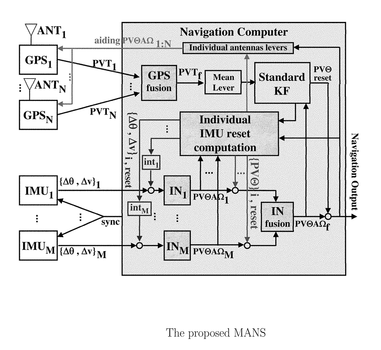
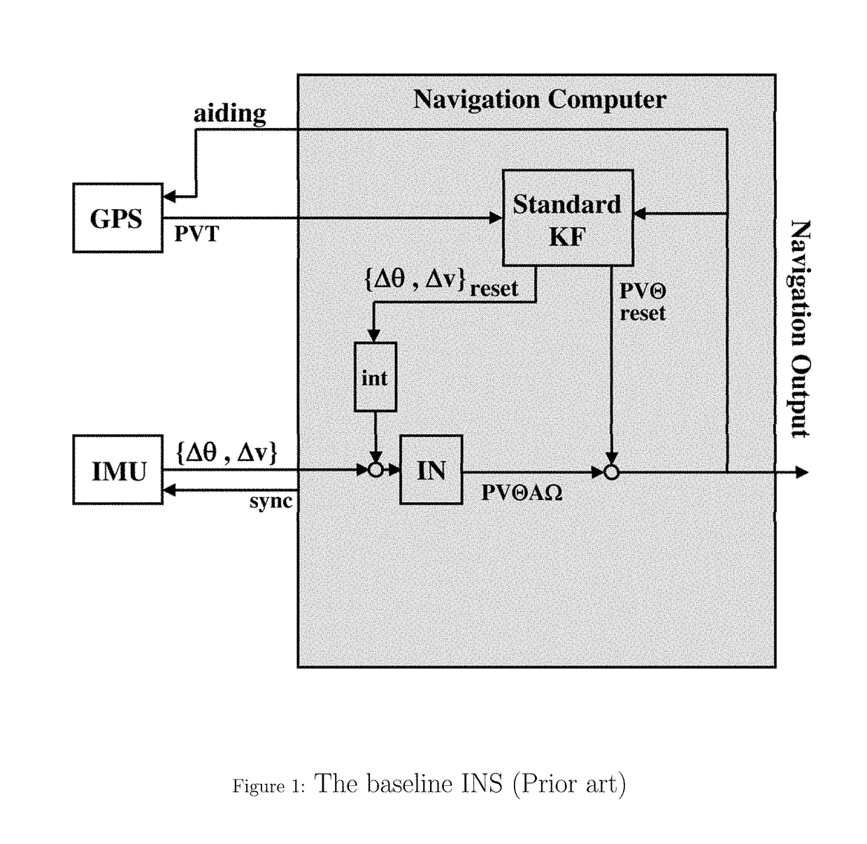
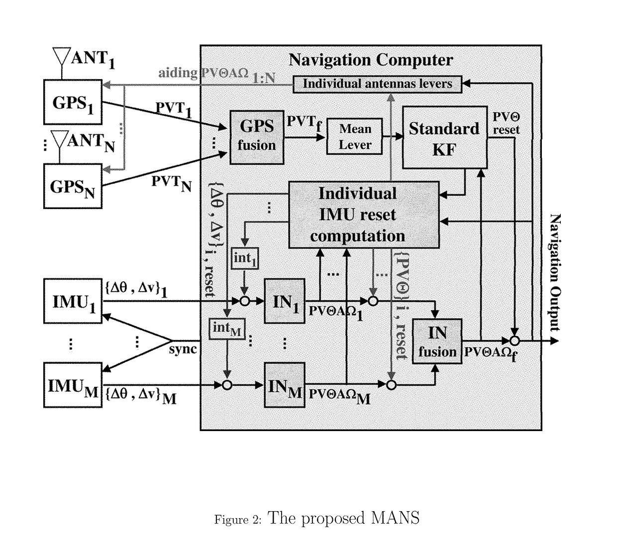
The Baseline INS

[0023]The INS assumed to exist (FIG. 1), and to be at hand and well-recognized, includes a single standard IMU, which provides coning and sculling-corrected {Δθ, Δν}; a single GPS receiver (with a single antenna), which provides {P, V, T} fixes; and a navigation computer which runs both an inertial navigation (IN) scheme and a standard navigation filter with the 15 standard error states {PVΘAΩ}. The filter customarily is a Kalman filter [KF], but may be some other filter, e.g. an unscented KF, an H∞ filter, a particle filter, etc. The position and velocity GPS fixes are corrected for the lever-arm effect of the body-vector between the IMU and antenna locations. These lever-arm corrections are performed, in the standard fashion, before passing the fixes to the filter. The computer uses the 1PPS signal from the GPS receiver, together with the receiver's time message, to adapt its own clock to GPS time and identify the fixes' timings. The computer also sends sync signal...


PUM


Abstract

A GPS-aided inertial navigation method includes providing multiple sensors including multiple inertial measurement units (IMUs) and at least one global positioning system receivers and antennas (GPSs) and computer with embedded navigation software. The computer interfaces with all IMUs and all GPS receivers; running, in parallel, in multiple standard inertial navigation (IN) schemes; computes the mean of all the INSs to obtain a fused IN solution for the IMUs' mean location; computes the mean of all the GPS solutions to obtain a fused GPS solution for the GPS antennas' mean location; applies a lever-arm correction, with the vector from the mean IMU location to the ‘mean antenna’ location, to the fused GPS solution; feeds the fused IN solution and the lever-arm corrected fused GPS solution to a single navigation filter, as if there were a single IMU and a single GPS; and runs an IMU / IN / GPS correction module.

Description

CROSS-REFERENCE TO RELATED PATENT APPLICATIONS[0001]This patent application is a U.S. National Phase Application under 35 U.S.C. 371 of International Application No. PCT / IL2015 / 050921, filed on 9 Sep. 2015, which claims priority from Israel Patent application 234691, filed on 16 Sep. 2014, the contents of which are incorporated by reference in their entirety.FIELD OF THE INVENTION[0002]The present invention concerns a multi-sensor (multi-IMU and multi-GPS) GPS-aided inertial navigation system and method.BACKGROUND OF THE INVENTION[0003]The subject of federated filtering, and specifically federated navigation with multiple IMUs, has received considerable attention over the past three decades. The paper by M. S. Mahmoud and H. M. Khalid, entitled “Distributed Kalman filtering: a bibliographic review”, in Control Theory & Applications, IET, Volume 7, Issue 4, 2013, Digital Object Identifier 10.1049 / iet-cta.2012.0732, contains a broad systematic review of distributed Kalman filtering, n...

Claims


Application Information

Patent Timeline
Patent Type & Authority Patents(United States)
IPC IPC(8): G01S19/47G01S19/49G01C21/16G01S19/40G01C21/28G01S19/03
CPCG01S19/03G01S19/40G01C21/28G01S19/47G01C21/16G01C21/165G01S19/49G01C21/185G01C21/188
Inventor BOYARSKI, SHMUEL
Owner IMI SYST LTD
Why Eureka
Try Eureka