
Geographic picture searching method

A picture search and geographic technology, applied in the field of geographic picture search, can solve the problems of finding installation locations, high cost, and low resolution in small and medium-sized cities, and achieve the effects of fast update frequency, reduced installation volume, and high resolution

Inactive Publication Date: 2007-10-03
马飞涛
View PDF1 Cites 28 Cited by
  • Summary
  • Abstract
  • Description
  • Claims
  • Application Information

AI Technical Summary

Problems solved by technology

[0002] Existing search engines, such as www.google.com, www.baidu.com, can only conduct a rough search through the surrounding text when searching for pictures; existing satellite maps and aerial maps, such as google earth, provide a top view , does not conform to the visual habits of ordinary users, and the cost is high, it is difficult to update in real time, and the resolution for small and medium cities is also very low
Existing electronic maps, such as www.go2map.com, display geographical information to users, but abstract lines and marks; existing GPS vehicle systems, because there are no cameras and image transmission systems installed on the vehicle, cannot collect and upload geographic images, and cannot Does not provide image search services to the public
For example, Chinese Patent Publication No. CN 1716335A discloses a road traffic real-time information investigation system, and the application number is 200510017848.6. Since cameras with fixed positions are only installed at important intersections, the cameras cannot move with the vehicle, and images outside the vehicle and geographic coordinates cannot be uploaded together. to the index server, making it impossible to have a comprehensive view of every street in the city: because even with a negligible investment in hardware costs, it is impossible to find a huge number of installation locations in the city

Method used


Image

  • Geographic picture searching method
  • Geographic picture searching method
  • Geographic picture searching method

Examples


Embodiment 1

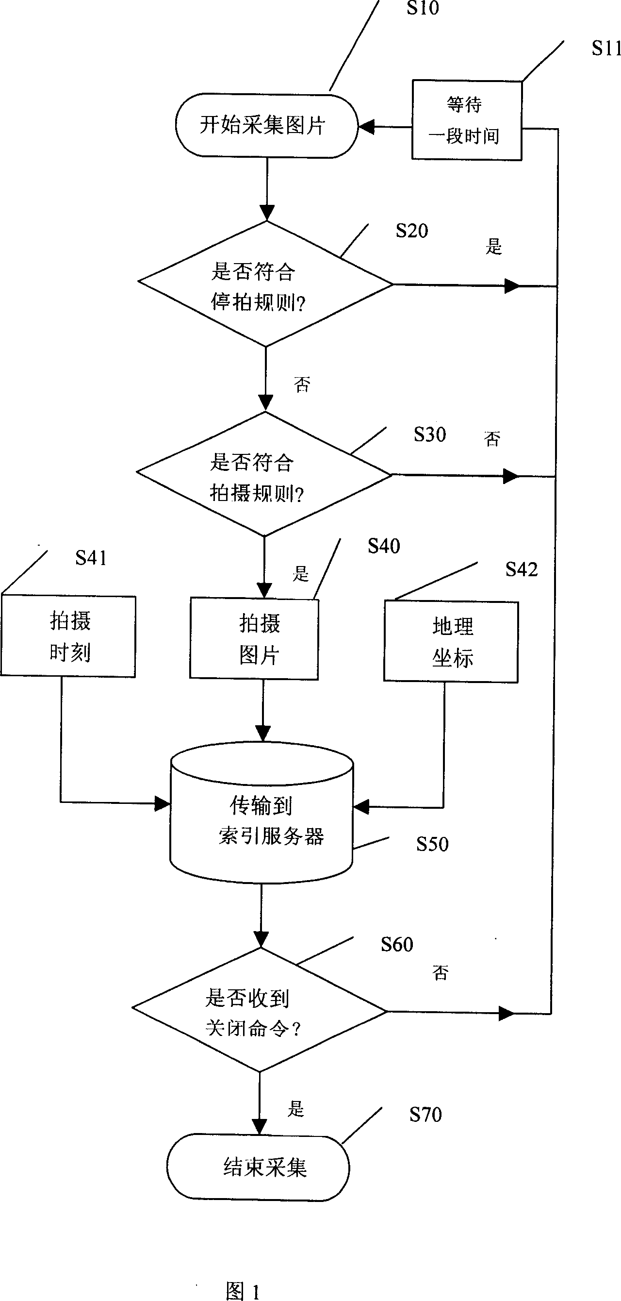
[0035] The industrial computer is installed in the trunk of each taxi, and the operating system of the industrial computer can be Windows, Linux or other operating systems. The programming tool can choose Visual c++, Delphi, Gcc or other software development tools. The industrial computer is connected to the GPS global positioning system or the CDMA geographic positioning system installed in the compartment or other locations through the serial port or other connection methods; the industrial computer is connected to the vehicle roof or other location of the camera connection. The camera is outside. According to the local tariff level, choose a GPRS wireless network card, or a CDMA wireless network card, or other wireless network device, and insert it on the motherboard of the industrial computer. This group of taxis can constitute a picture collector of this city.

Embodiment 2

[0037] Choose to possess the mobile phone that GPS global positioning system and camera can be connected to the Internet, and this mobile phone is installed in the car window of every taxi or other positions, and camera is external. The operating system of the mobile phone can be selected from Symbian, Windows CE, Linux, Palm or other operating systems. The programming language can choose Java, C, or other programming languages. This group of taxis can constitute a picture collector of this city.

Embodiment 3

[0039] On the train, long-distance bus or ship, install the industrial computer, the operating system of the industrial computer can choose Windows, Linux or other operating systems. The programming tool can choose Visual c++, Delphi, Gcc or other software development tools. The industrial computer is connected to the GPS global positioning system or the CDMA geographic positioning system installed in the compartment or other locations through the serial port or other connection methods; the industrial computer is connected to the vehicle roof or other location of the camera connection. The camera is outside. The transmission method can adopt wireless transmission method, choose GPRS wireless network card, or CDMA wireless network card, or other wireless network devices, and insert it on the motherboard of the industrial computer. The transmission method can also adopt the storage medium transfer method, and a large-capacity hard disk is installed in the industrial computer ...


PUM


Abstract

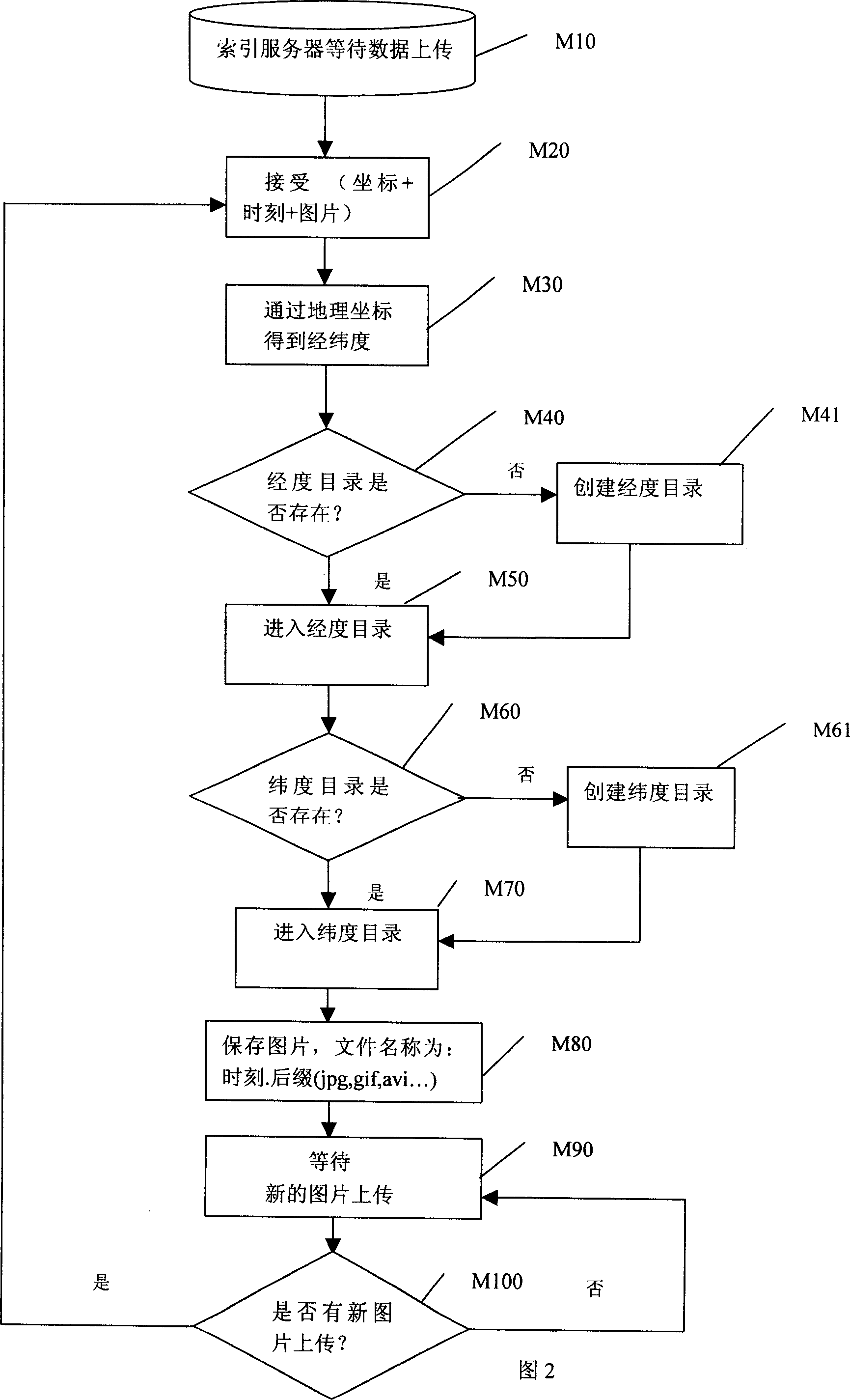
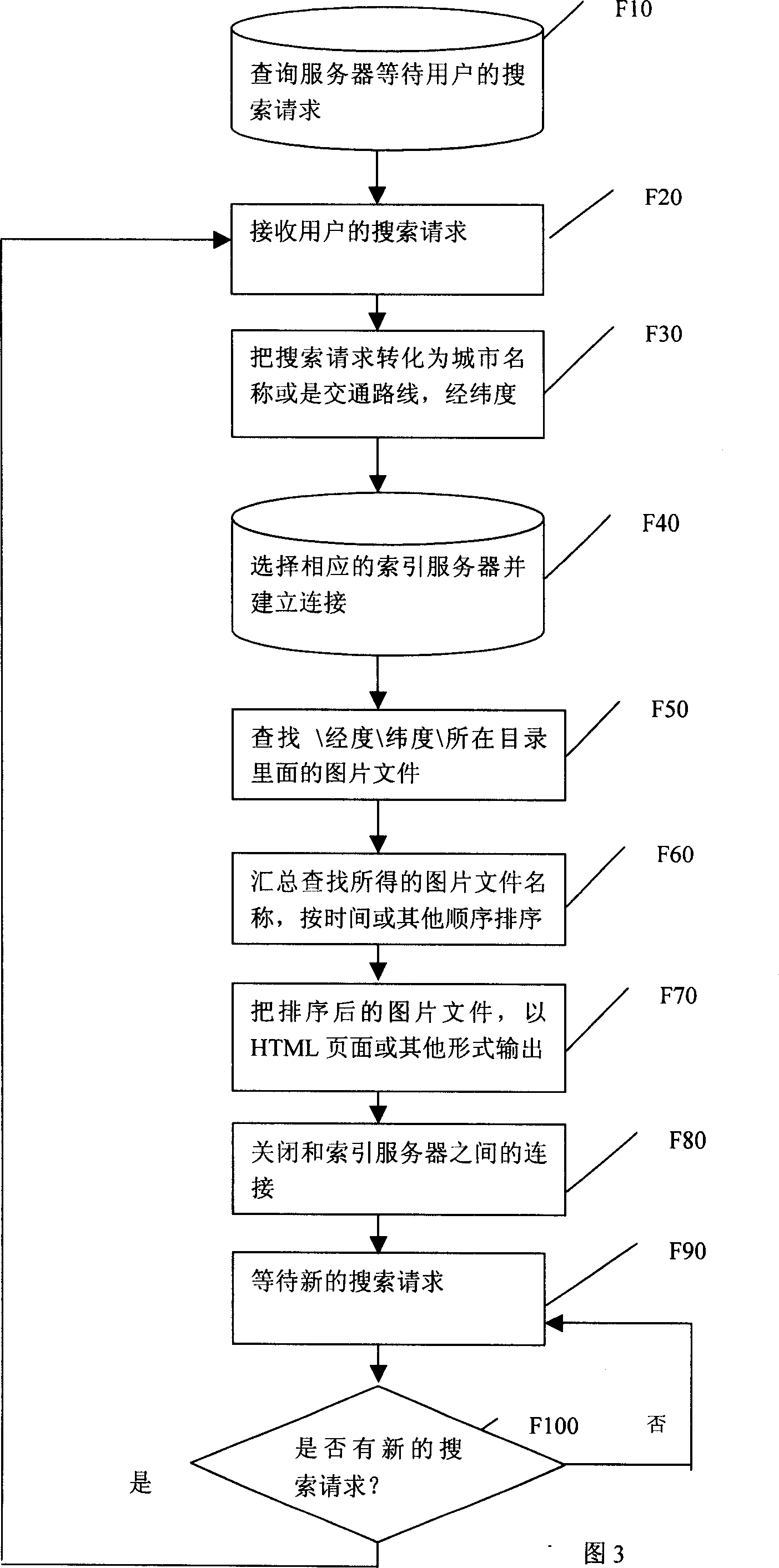
The present invention discloses a geographic map picture search method, relates to interconnected network search engine and electronic map technique, and is aimed at accurately searching geographic map picture. Said method utilizes the system containing map picture collector, index server and inquiry server to implement the functions of shooting geographic image, indexing and searching geographic map picture. Besides, said invention also provides the concrete operation steps of said geographic map picture search method.

Description

technical field [0001] The invention relates to Internet search engine and electronic map technology, in particular to a geographic image search method. Background technique [0002] Existing search engines, such as www.google.com, www.baidu.com, can only conduct a rough search through the surrounding text when searching for pictures; existing satellite maps and aerial maps, such as google earth, provide a top view , does not conform to the visual habits of ordinary users, and the cost is high, it is difficult to update in real time, and the resolution for small and medium-sized cities is also very low. Existing electronic maps, such as www.go2map.com, display geographical information to users, but abstract lines and marks; existing GPS vehicle systems, because there are no cameras and image transmission systems installed on the vehicle, cannot collect and upload geographic images, and cannot Image search services are not provided to the public. For example, Chinese Patent...

Claims


Application Information

Patent Timeline
IPC IPC(8): G06F17/30
Inventor 马飞涛
Owner 马飞涛
Learn More