Locating method for satellite navigation reinforcing system

A technology of an enhancement system and a positioning method, which is applied in the positioning field of a satellite navigation enhancement system, can solve the problems of increasing positioning error and increasing distance between the user and the ground station, and achieves the effect of improving robustness and good navigation performance.

Inactive Publication Date: 2008-01-23
BEIHANG UNIV
View PDF0 Cites 47 Cited by
  • Summary
  • Abstract
  • Description
  • Claims
  • Application Information

AI Technical Summary

Problems solved by technology

[0017] The purpose of the present invention is to provide a positioning method for a satellite navigation augmentation system, which can improve the positioning accuracy and improve the robustnes...

Method used


Image

  • Locating method for satellite navigation reinforcing system
  • Locating method for satellite navigation reinforcing system
  • Locating method for satellite navigation reinforcing system

Examples


Embodiment Construction

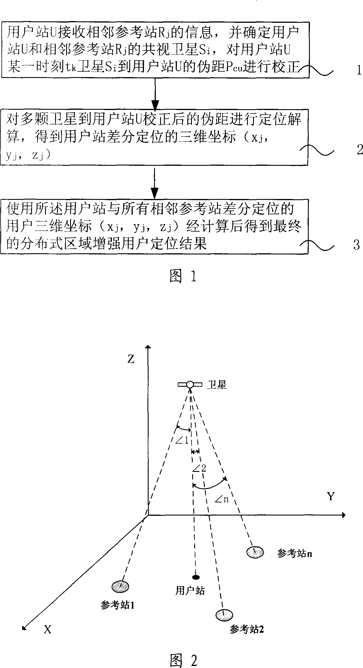
[0041] Fig. 1 is the flow chart of the specific embodiment 1 of the positioning method of a kind of satellite navigation augmentation system of the present invention, as shown in Fig. 1, this embodiment comprises the following steps:

[0042] Step 1: User station U receives neighboring reference station R j information, and determine the user station U and the adjacent reference station R j common view satellite S i , for user station U at a certain time t k Satellite S i Pseudorange P to user station U CU make corrections;

[0043] Step 2: Perform positioning calculation on the corrected pseudo-ranges from multiple satellites to the user station U, and obtain the three-dimensional coordinates of the differential positioning of the user station (x j ,y j ,z j );

[0044] Step 3: use the user station three-dimensional coordinates (x j ,y j ,z j ) is calculated by weighted average to obtain the final distributed area enhanced user positioning result.

[0045] In the ab...


PUM


Abstract

The invention relates to a positioning method for a satellite navigation enhancing system comprising such procedures as, a user station receives info from an adjacent reference station, and determines the mutually-visual satellite of the user station and the adjacent reference station, and calibrates the pseudo distance from a satellite to the user station in a time period; a reference station adjacent to the user station is used to carry out positioning resolution of the calculated pseudo distance from a plurality of satellites to the user station, so as to get the 3D coordinates of the differential positioning of the user station; the positioning result of the user is enhanced by using the final distributed area got by weighted average calculation of 3D coordinates of differential positioning of the user station and all adjacent reference stations. The invention enhances the positioning accuracy for a user by using the enhancing info from a plurality of local areas in a foundation enhancement covered area in respect to the shortcoming that the positioning accuracy is greatly reduced when the user is far from the ground station and a big difference exists between the delay error of the ground station and that of the ionized stratum and the troposphere of the user.

Description

technical field [0001] The invention relates to a positioning method of a satellite navigation augmentation system, in particular to a positioning method of a satellite navigation distributed ground-based area augmentation system. Background technique [0002] Satellite navigation systems, such as the US Global Positioning System (GPS for short) and the Russian Global Navigation Satellite System (GLObal NAvigation Satellite System for short GLONASS), are widely used in various aspects of national security and national economy. For some application fields, satellite navigation without enhancement cannot meet the application requirements in terms of accuracy and so on. [0003] In terms of satellite navigation augmentation system, there are mainly wide-area augmentation, local-area augmentation, and receiver autonomous augmentation. Wide-area enhancement provides enhanced performance with a positioning accuracy of several meters for a larger geographic range (such as a radius...

Claims


Application Information

Patent Timeline
IPC IPC(8): G01S5/14H04Q7/38G01S19/38
Inventor 张军朱衍波刘强薛瑞王志鹏
Owner BEIHANG UNIV
Why Eureka
Try Eureka