Method for providing assistance data to a mobile station of a satellite positioning system

一种卫星定位系统、辅助数据的技术,应用在卫星无线电信标定位系统、定位、无线电波测量系统等方向,能够解决依赖、成本高昂等问题

Active Publication Date: 2008-11-12
THE EURO UNION REPRESENTED BY THE EURO CO
View PDF4 Cites 19 Cited by
  • Summary
  • Abstract
  • Description
  • Claims
  • Application Information

AI Technical Summary

Problems solved by technology

Carriers currently have the option of building this network alone, but doing so is expensive, or they may have a service agreement with the owner of this baseline network, which would make it dependent on another party

Method used


Image

  • Method for providing assistance data to a mobile station of a satellite positioning system
  • Method for providing assistance data to a mobile station of a satellite positioning system
  • Method for providing assistance data to a mobile station of a satellite positioning system

Examples


Embodiment Construction

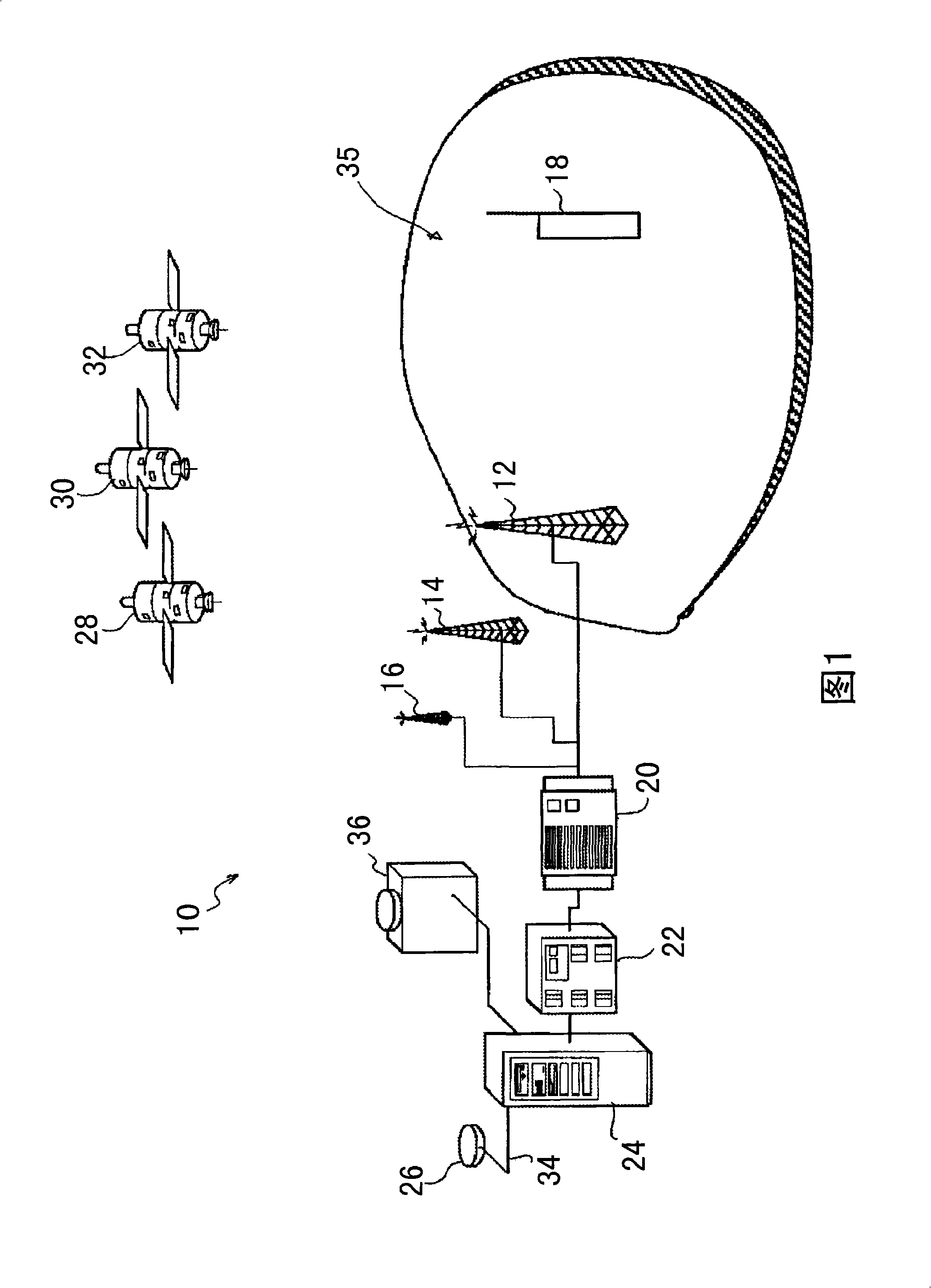
[0022]Figure 1 illustrates the components of a communication system 10 utilizing a satellite positioning system such as GPS, GLONASS, Galileo, or a combination thereof. Communication system 10 includes stationary infrastructure, such as base stations 12, 14, 16, and mobile stations 18, such as mobile telephones as shown in FIG. The stationary infrastructure also includes a base station controller (BSC) 20 , a serving mobile location center (SLMC) 22 and an AGNSS server 24 . Stationary infrastructure typically interfaces with mobile stations 18 using land-based communications networks and / or the Internet.

[0023] The AGNSS server is connected to a reference GNSS receiver 26 which receives ephemeris data broadcast by those GNSS satellites 28, 30, 32 visible from its position. Communication between reference receiver 26 and AGNSS server 24 may be based on Internet Protocol or any other suitable protocol. Server 24 receives broadcast ephemeris data from reference receiver 26 vi...


PUM


Abstract

Satellites of a satellite positioning system broadcast within the navigation signals ephemeris data having a certain period of validity. At a mobile station, ephemeris data are required for position-fixing. In assisted satellite positioning systems, acquisition of navigation signals emitted by the satellites is facilitated as assistance data are provided to the mobile station. At a server station, a request for assistance data issued by said mobile station is received, and the server station transmits ephemeris data as part of the assistance data to the mobile station in response to its request. Upon receiving the request for assistance data issued by said mobile station, the server station decides whether the mobile station could achieve a specified position fix accuracy if the mobile station was provided with the broadcast ephemeris data. In the positive, the server station transmits the broadcast ephemeris data to the mobile station. In the negative, the server station transmits, instead of broadcast ephemeris data, long-term ephemeris data to the mobile station as part of the assistance data requested. The long-term ephemeris data are derived from satellite orbit predictions and have a period of validity substantially increased with respect to the ephemeris data broadcast by the satellites.

Description

technical field [0001] Generally speaking, the present invention relates to how to use a satellite positioning system for positioning. Specifically, the present invention relates to a method for providing auxiliary data for a mobile station to help the mobile station locate. Background technique [0002] GNSS (Global Navigation Satellite System) receivers determine their distance to satellites orbiting the Earth to determine their geographic location. If the distance from the receiver to the satellite, and the location of the satellite, are known, the position of the receiver can be calculated. Since the positions of satellites change over time, receivers need a description of how their orbits change over time. As a rule of thumb, it can be assumed that an error of 100 meters in the satellite position translates into an error of about 25 meters in the position determined by the receiver. Therefore, each satellite transmits ephemeris data as a description of its orbit in a...

Claims


Application Information

Patent Timeline
Patent Type & Authority Applications(China)
IPC IPC(8): G01S1/00G01S19/05G01S19/25G01S19/27
CPCG01S19/05G01S19/258G01S19/27G01S5/14
Inventor S·科拉扎M·莫内拉
Owner THE EURO UNION REPRESENTED BY THE EURO CO
Why Eureka
Try Eureka