Storage monitoring method

A storage capacity and water body technology, applied in the direction of measuring devices, radio wave measurement systems, instruments, etc., can solve problems such as lack of storage capacity and failure to obtain storage capacity through remote sensing images, and achieve the effect of improving speed and accuracy

Inactive Publication Date: 2009-02-04
常熟紫金知识产权服务有限公司
View PDF0 Cites 37 Cited by
  • Summary
  • Abstract
  • Description
  • Claims
  • Application Information

AI Technical Summary

Problems solved by technology

[0022] Based on the literature listed above, many scholars have conducted a series of studies on the application of spatial information technology in storage capacity monitoring. Some scholars use digital maps or DEM to estimate storage capacity. These methods only consider the water surface level. The most important is the static storage capacity; some scholars use remote sensing images to extract water body area and study the relationship between water surface area and storage capacity, but they have not obtained the specific value of storage capacity through remote sensing images; Approximate parallelogram and triangular space body to calculate, this method depends on the shape of the river bed
Therefore, the field of hydraulic engineering lacks an effective technology capable of real-time monitoring of storage capacity

Method used


Image

  • Storage monitoring method
  • Storage monitoring method
  • Storage monitoring method

Examples


Embodiment Construction

[0047] The technical solution of the present invention is described in detail below based on specific embodiments:

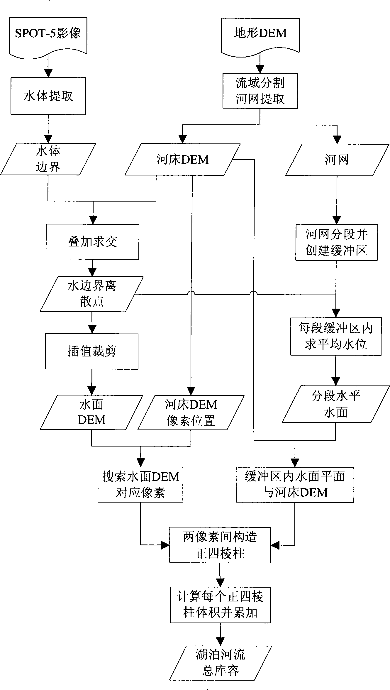
[0048] Step 1: Carry out orthorectification on the remote sensing image above the water body to be measured, and then extract the boundary of the water body to be measured according to the remote sensing image, and obtain the boundary polygon of the water body.

[0049] The orthorectification of remote sensing images is to use control points to correct the geometric deformation of the original image and generate a new image that meets the requirements of a certain map projection or map expression. It takes all kinds of errors and distortions on the map as a whole, uses a certain number of control points to establish a mathematical model, and uses this model to establish a certain mapping transformation or corresponding transformation relationship between the image to be corrected and the standard image space, and then according to This transformation function tr...


PUM


Abstract

The invention relates to a reservoir capacity monitoring method, comprising the following steps: carrying out ortho rectification to a remote sensing image above the water body to be monitored, and then extracting the water body boundary through the remote sensing image so as to obtain a water body boundary polygon; overlapping the water body boundary polygon on the topographic DEM and extracting the intersection points between the water body boundary polygon and the topographic DEM as three-dimensional water boundary discrete points; interpolating the three-dimensional water boundary discrete points to obtain the water surface DEM; and evaluating the cubage contained between the water surface DEM and the topographic DEM terrain, so that the reservoir capacity monitoring result of the water body to be monitored is obtained. The invention makes use of the remote sensing and GIS and other spatial information technologies to accurately monitor the water surface as a curved surface, as well as the total reservoir capacity including the dynamic reservoir capacity. The invention also provides an optimization mode based on river segmentation and creates a buffer zone to enable the calculation to be controlled in an effective region, so the invention is provided with high precision and efficiency and has an operational popularization and application prospect.

Description

technical field [0001] The invention belongs to the application technology of spatial information technology in the field of hydraulic engineering, and in particular relates to a storage capacity monitoring method. Background technique [0002] The research on the water storage capacity of lakes and reservoirs has always been an important aspect in the study of the terrestrial water cycle. However, on a global scale, the traditional methods given to the land surface monitoring network have very limited research and grasp capabilities, and have long been unable to meet practical applications. The requirements for data accuracy and update speed. With the increasing maturity and perfection of space information technology, more and more researchers at home and abroad apply this technology to various fields of water conservancy and hydropower construction. [0003] Remote sensing information has the characteristics of periodicity, macroscopicity and practicality. Therefore, usin...

Claims


Application Information

Patent Timeline
Patent Type & Authority Applications(China)
IPC IPC(8): G01S17/00
Inventor 陆建忠陈晓玲蔡晓斌李辉殷守敬田礼乔
Owner 常熟紫金知识产权服务有限公司
Why Eureka
Try Eureka