Local airport monitoring method and system based on multi-receiver

A multi-receiver and monitoring system technology, applied in the field of satellite navigation, can solve problems such as failure to meet system performance indicators, failure to guarantee system robustness and continuity, and impact on LAM system integrity and availability, so as to improve integrity and improve The effect of monitoring and judging ability

Inactive Publication Date: 2009-04-29
BEIHANG UNIV
View PDF0 Cites 19 Cited by
  • Summary
  • Abstract
  • Description
  • Claims
  • Application Information

AI Technical Summary

Problems solved by technology

However, the design of LAM in the prior art is based on a single receiver. If the receiver fails, it will affect the integrity and availability of the LAM syst

Method used


Image

  • Local airport monitoring method and system based on multi-receiver
  • Local airport monitoring method and system based on multi-receiver
  • Local airport monitoring method and system based on multi-receiver

Examples


Example Embodiment

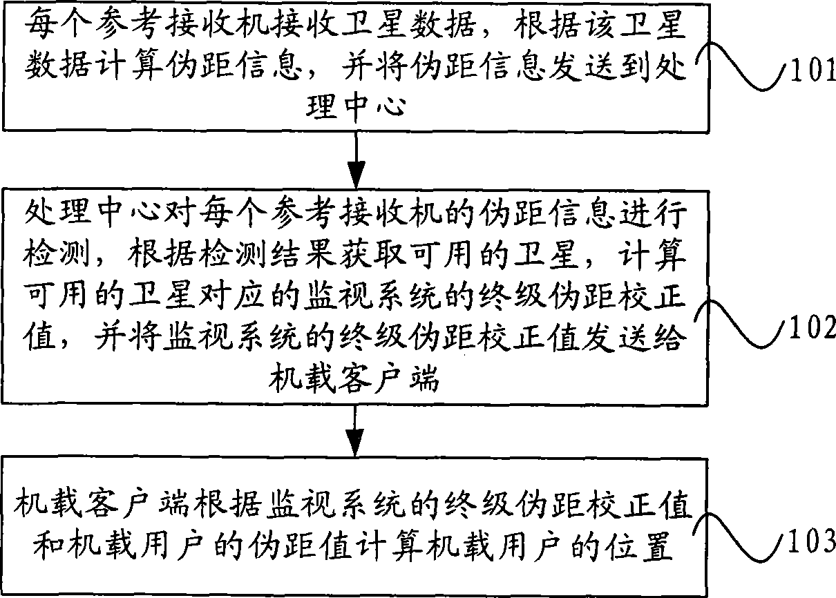
[0019] The technical solutions of the present invention will be further described in detail below through the accompanying drawings and embodiments.

[0020] With the vigorous development of satellite navigation, countries all over the world are building their own satellite navigation systems, such as the GPS system in the United States, the GLObal NAvigation Satellite System in Russia (GLObal NAvigation Satellite System; hereinafter referred to as GLONASS), as well as European satellite systems under construction. Galileo (Galileo) system. However, due to the influence of ionosphere, troposphere, multipath effect and thermal noise, as well as the satellite navigation system's own problems such as ephemeris error, star clock error, etc., satellite navigation cannot meet the performance indicators required by the system in many applications. For example, in the application of precision approach systems for civil aviation aircraft, not only high requirements are placed on the accura...


PUM


Abstract

The invention discloses a method for monitoring a local airport based on a plurality of receivers and a system. The method comprises the following steps: each reference receiver receives satellite data; pseudo-distance information is calculated according to the satellite data, wherein the pseudo-distance information comprises pseudo-distance corrected value of a wide area augmentation system, pseudo-distance corrected value of local monitoring and pseudo-distance corrected value of a monitoring system; the pseudo-distance information is sent to a processing center; the processing center detects the pseudo-distance information of each reference receiver, acquire a usable satellite according to the detecting result, calculates ultimate pseudo-distance corrected value of the monitoring system corresponding to the satellite, and sends the ultimate pseudo-distance corrected value of the monitoring system to an airborne client; and the airborne client calculates the position of an airborne user according to the ultimate pseudo-distance corrected value of the monitoring system and pseudo-distance value of the airborne user. The system comprises a plurality of reference receivers, the processing centers and airborne clients. The method improves integrity, usability and continuity of the system on the premise of guaranteeing precision of the system.

Description

technical field [0001] The invention relates to satellite navigation technology, in particular to a multi-receiver-based local area airport monitoring method and system. Background technique [0002] With the continuous development of satellite navigation technology, the satellite navigation systems built by various countries can no longer meet the performance indicators required by the system, such as accuracy, integrity, continuity, and availability. Area Augmentation System (hereinafter referred to as: WAAS), Local Area Augmentation System (hereinafter referred to as: LAAS) and European Geostationary Navigation Overlay Service (hereinafter referred to as: EGNOS) and other inventions are all used for enhanced satellite navigation systems. Among them, the research on WAAS began in the early 1990s in the Global Positioning System (Global Positioning System; hereinafter referred to as: GPS) integrity channel (GPS Integrality Channel l; hereinafter referred to as GIC) and the...

Claims


Application Information

Patent Timeline
IPC IPC(8): G01S5/02G01S5/14
Inventor 张军朱衍波王志鹏薛瑞张淼艳
Owner BEIHANG UNIV
Why Eureka
Try Eureka