Optimized data transmission method based on geographical position in vehicle-mounted network

A technology for geographic location and data optimization, applied in the field of network communication, it can solve problems such as outdated location information, unstable neighbor relationship between nodes, and inability to ensure information accuracy, so as to improve quality, achieve reliability and information accuracy, Effectiveness to ensure accuracy and consistency

Inactive Publication Date: 2009-05-13
TIANJIN UNIV
View PDF0 Cites 26 Cited by
  • Summary
  • Abstract
  • Description
  • Claims
  • Application Information

AI Technical Summary

Problems solved by technology

However, in the VANET network, due to the instability of the neighbor relationship between nodes caused by the rapid movement of nodes, the location information used in routing is outdated.
i.e. it does not guarantee the accuracy of the information

Method used


Image

  • Optimized data transmission method based on geographical position in vehicle-mounted network
  • Optimized data transmission method based on geographical position in vehicle-mounted network
  • Optimized data transmission method based on geographical position in vehicle-mounted network

Examples


Embodiment Construction

[0045] The method for optimizing data transmission based on geographic location in the vehicle network of the present invention will be described in detail below with reference to the embodiments and the accompanying drawings.

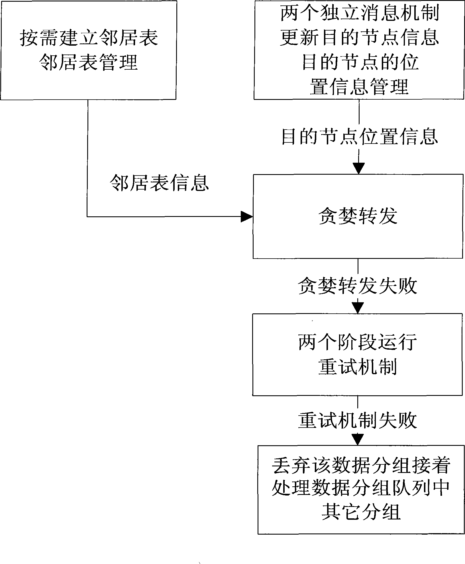
[0046] Such as figure 1 As shown, the basic framework principle of the optimal data transmission method based on geographic location in the vehicle-mounted network of the present invention is that when a node has data to send, it first establishes a temporary neighbor list in real time as needed, and periodically sends it according to the received destination node. The location update message of the destination node is used to update the location information of the destination node. Afterwards, the greedy forwarding strategy is adopted to forward the packet. If no suitable next hop is found, the retry mechanism will be used to search for the next hop again. After the retry mechanism finally fails, the data packet is discarded, and other data packets i...


PUM


Abstract

The invention relates to a method for transmitting optimized data in vehicular network based on geographic position. The method is as follows: a source node sends target node position request information; the target node responds to the target node position request information, and periodically updates position information of the target node on each node; a neighbor requests sending information; another neighbor answers sending the information, and the position information is obtained through a vehicular GPS system; transmission of data packet: data are transmitted in packet by routing greed transmitting arithmetic in a protocol according to a common geographic position; two retry systems during data transmission are as follows: the retry systems are started when the greed transmission does not find proper next jump at the data transmission, and the systems have two stages: one is only to increase reserved time for waiting neighbor table establishment; and the other one sends out new neighbor request message, and fully reestablishes a neighbor table. The method reserves multiple advantages of the prior mature route protocol well, and can be simply applied in the prior network without large range of change.

Description

technical field [0001] The invention relates to a network communication technology. In particular, it relates to an on-demand geographic location information acquisition method and a reliable route calculation method for transmitting data packets in a vehicle-mounted ad hoc network, which is an optimal data transmission method based on geographic location in a vehicle-mounted network. Background technique [0002] Vehicles play a huge role in contemporary society. While the use of vehicles brings convenience to people's lives, it also brings some headaches, such as frequent traffic accidents and traffic jams. These problems directly threaten people's lives, bring great troubles to people's lives, and become problems that governments of all countries need to solve urgently. With the rapid development of wireless communication technology and the continuous improvement of automotive electronic technology, many governments and research institutions are trying to solve these pr...

Claims


Application Information

Patent Timeline
Patent Type & Authority Applications(China)
IPC IPC(8): H04W40/02H04L12/56H04W84/18
Inventor 金志刚罗咏梅闫宁霄张赛男
Owner TIANJIN UNIV
Why Eureka
Try Eureka