3D terrain imaging system of interferometric synthetic aperture radar and elevation mapping method thereof

An interferometric synthetic aperture, three-dimensional terrain technology, applied in the field of radar, can solve the problems of high complexity of phase unwrapping algorithm, slow continuous change, violent deformation of landform, etc. Increase the effect of blur height

Inactive Publication Date: 2009-10-07
XIDIAN UNIV
View PDF0 Cites 68 Cited by
  • Summary
  • Abstract
  • Description
  • Claims
  • Application Information

AI Technical Summary

Problems solved by technology

[0004] The traditional two-aperture airborne interferometric synthetic aperture radar, because there are only two receiving apertures, can receive only one interferometric phase image, which leads to the traditional airborne interferometric synthetic aperture radar's three-dimensional imaging must rely on the interferometric phase The phase gradient between adjacent pixels in the map is the fundamental reason why the three-dimensional terrain that can be observed by traditional airborne interferometric synthetic aperture radar must require slow and continuous changes
In fact, this requirement for slow or continuous terrain changes is very harsh for the actual terrain, which leads to very limited terrain that can be observed by traditional airborne interferometric synthetic aperture radars
For example, during the Wenchuan earthquake in 2008, due to the steep mountains in the Wenchuan area and the severe deformation of the landform caused by the earthquake, the traditional airborne interferometric synthetic aperture radar was powerless to deal with the above-mentioned terrain
[0005] The traditional two-aperture airborne interferometric synthetic aperture radar, its three-dimensional elevation imaging is based on the phase gradient information of adjacent pixels, which leads to high complexity of phase unwrapping algorithm and long operation time
Because emergencies such as earthquakes and landslides have very high requirements for the effectiveness of radar surveying and mapping, it is difficult for the traditional two-aperture airborne interferometric synthetic aperture radar to meet the requirements of real-time surveying, mapping and imaging.

Method used


Image

  • 3D terrain imaging system of interferometric synthetic aperture radar and elevation mapping method thereof
  • 3D terrain imaging system of interferometric synthetic aperture radar and elevation mapping method thereof
  • 3D terrain imaging system of interferometric synthetic aperture radar and elevation mapping method thereof

Examples


Embodiment Construction

[0028] The system structure and elevation measurement process of the present invention will be described in detail below in conjunction with the accompanying drawings.

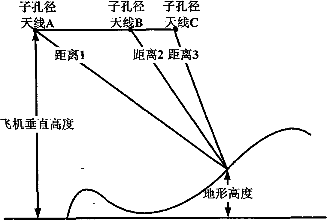
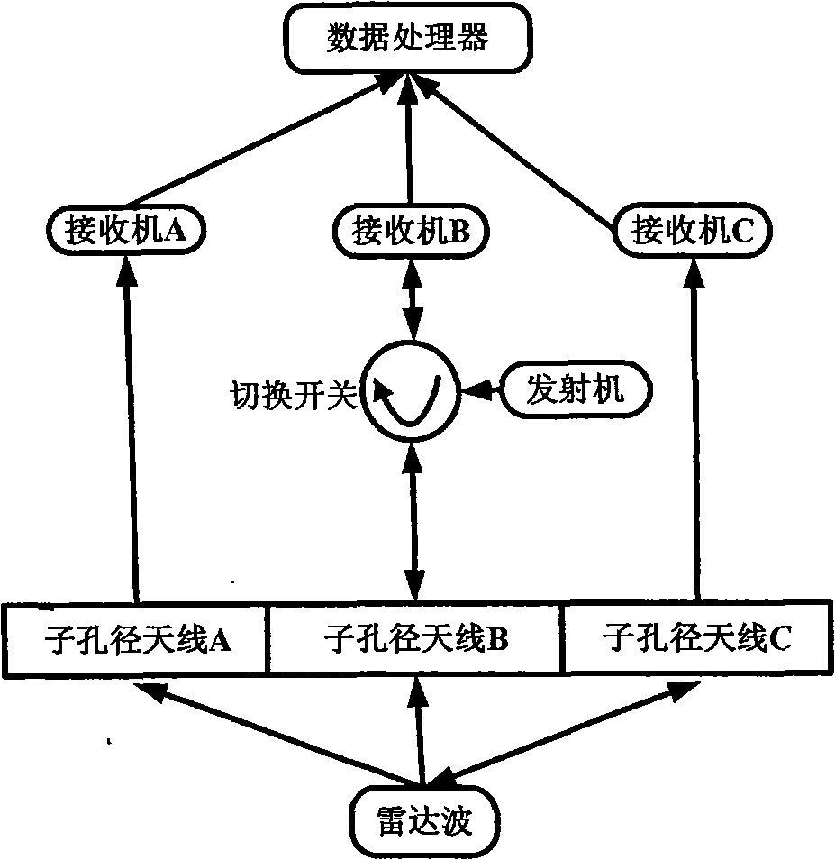
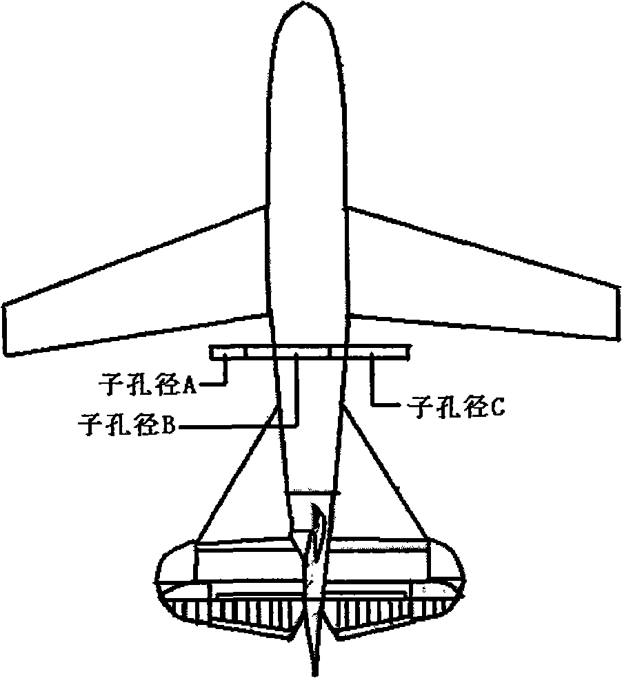
[0029] refer to figure 2 , The interferometric synthetic aperture radar system of the present invention includes: three sub-aperture antennas, a radar wave transmitter, a radar wave receiver and an imaging data processor. When the radar is working, the radar wave transmitter first sends radar pulses through the entire aperture antenna or a sub-aperture, and the radar echoes are received simultaneously by the radar wave receivers of the three sub-aperture antennas, and the received signals are transmitted to their respective The data processor, that is, the radar is first switched to the radar wave transmission mode by the switch when it is working. At this time, the radar wave transmitter transmits through the entire aperture antenna or any one of the sub-aperture antenna A, sub-aperture antenna B, and sub-ap...


PUM


Abstract

The invention discloses a 3D terrain imaging system of the interferometric synthetic aperture radar (InSAR) and an elevation mapping method thereof, which mainly solve the problems that the existing InSAR has bad imaging pragmaticality and can not implement 3D elevation mapping on the fast-changing terrain and the transilient terrain. The system comprises three sub-aperture antennas, a radar transmitter, a radar receiver and an imaging data processor; the imaging signal processor comprises a SAR image processing unit and an InSAR image processing unit. The invention receives radar echo through the three sub-apertures, then conducts SAR imaging process on the radar echo respectively received by the three sub-apertures, and then conducts InSAR imaging process on the obtained SAR complex pattern, wherein the InSAR imaging process comprises image registration, phase filtering and phase unfolding based on cluster analysis. The processed InSAR phase unfolded image is processed with an elevation inversion to recover a three dimensional digital elevation map. The invention has the advantages of wide adaptability to mapped terrains, and high imaging effectiveness, therefore, the invention can be used in the mapping of the 3D terrain.

Description

technical field [0001] The invention belongs to the field of radar technology, in particular to an interference synthetic aperture radar system, which can be used for the measurement of three-dimensional elevation terrain by airborne interference synthetic aperture radar. Background technique [0002] Interferometric Synthetic Aperture Radar InSAR is a technology that uses the phase information extracted from the complex data obtained by Synthetic Aperture Radar SAR as the information source to obtain the three-dimensional information and change information of the earth's surface. Traditional InSAR obtains complex image pairs of the same ground scene through simultaneous observation by two antennas, or two near-parallel observations. Since the geometric relationship between the ground target and the two antenna positions produces a phase difference on the complex image, interference fringes containing the difference information between the ground target and the two antenna p...

Claims


Application Information

Patent Timeline
Patent Type & Authority Applications(China)
IPC IPC(8): G01S13/90
Inventor 李真芳于瀚雯索志勇郭交刘艳阳王萍
Owner XIDIAN UNIV
Why Eureka
Try Eureka